Essential Planning Guide
Audens Col Expedition — Complete Guide (2026)
Introduction
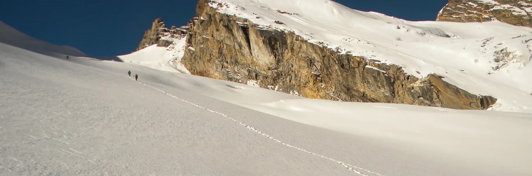
Discovered by J.B. Auden in 1939, Auden's Col is not a trek—it is a brutal, highly technical Himalayan expedition. Functioning as a high-altitude glaciated bridge between the towering peaks of Gangotri III (6,577m) and Jogin I (6,465m), the col itself sits at an unforgiving 18,010 ft. It binds two of Hinduism's most sacred sites: from the origin of the Ganges at Gangotri, crossing the lethal Khatling Glacier, down into the Kedarnath valley. This route requires deep familiarity with roped up glacier travel, crevasse rescue techniques, ice-axe self-arrests, and crampon use. The descent from the col onto the Khatling Glacier is an 80-degree near-vertical drop over shattered ice and bottomless crevasses. It is meant only for elite mountaineers and experienced high-altitude Himalayan veterans seeking one of India's most punishing and legendary traverses.
Ready to book? Compare verified operators for Audens Col Expedition — transparent pricing, no paid rankings.
Quick Facts
Duration
Max Altitude
Difficulty
Best Time
Trek Distance
Trail Atmosphere
Stargazing
Class 1 Dark Sky
Scent Profile
Silence Level
~5 dB
Vertigo Factor
5 / 10
Primarily a cumulative fatigue and altitude exposure challenge
A demanding expedition with extreme cumulative fatigue and altitude exposure.
Iconic Spots
Auden's Col Vista
Getting There
Route to Base
10-12 hour drive from Dehradun/Rishikesh to Gangotri Town
Base Village
Gangotri
10,000 ft
Nearest Railhead
Dehradun (DDN) / Haridwar (HW)
Nearest Airport
Jolly Grant Airport, Dehradun (DED)
Last ATM
Uttarkashi
Nearest Medical Facility
Uttarkashi Hospital
Mobile Signal
Zero.
Water Sources
Melted snow on the glaciers.
Charging
Zero.
For Drivers
Road Condition
Long exhausting drive to Gangotri.
Uttarkashi
Trail Culinary & Diet
Don't miss the N/A
Buy specialized diet items at Dehradun
The Content & Remote Hub
No DronesPermit near impossible near international borders.Top Vlog Spots
Video Calls
none
Est. 0 Mbps
UPI Reliability
1/10
Guide Wisdom
Caution
Keep your crampons razor sharp. The blue ice on the Khatling descent will laugh at dull points, causing you to slip.
Explore In Detail
Day by Day Itinerary
15-day route reaching 18,012ft. Covers 75km of varied terrain.
→ See full itinerary with altitude profileDifficulty & Fitness
Rated challenging. 60% of the trek is on technical, shifting moraine, blue ice, or snow. The trail frequently disappears. Crevasses pose a constant hazard on Khatling.
→ See difficulty breakdown and fitness guideCost & Pricing
Packages range from ₹45,000 to ₹75,000. Inclusions and hidden costs vary by operator tier.
→ See full cost breakdownPermits and Regulations
Highly restricted. Requires expedition-level clearance from the Indian Mountaineering Foundation (IMF) and the Uttarakhand Forest Department. All participants must submit advanced climbing resumes and comprehensive insurance covers that explicitly include helicopter extraction above 5000m.
Learn more about how we vet operators and ensure transparency on our why MountRoutes page.
Packing List
Technical Mountaineering Gear
- Crampons (12-point mandatory, checked for boot compatibility)
- Ice Axe (Straight shaft, general mountaineering type)
- Climbing Harness & 2 Locking Carabiners
- Jumar and Descender (Figure 8/ATC)
- Helmet (UIAA Certified)
Extreme Weather Survival
- Expedition Down Jacket (Rated to -25°C)
- Double-layer insulated expedition boots (e.g., La Sportiva Spantik) or heavy rigid plastics
- Gore-Tex Hardshell Pants and Jacket
- Category 4 Glacier Glasses (Wrap-around styling to prevent snow blindness)
Camping & Safety
- Four-season expedition tent
- Sleeping bag (-20°C comfort rating minimum)
- Personal Medical Kit with Diamox and Dexamethasone
Flora & Fauna
Flora
Fauna
The route directly connects the Gangotri and Kedarnath shrines over the harshest terrain possible, historically attempted only by the most devout and ascetic sadhus.
— Local folklore
Spiritual & Cultural Significance
Connects Gangotri and Kedarnath.
🕐 Shrine Timings: N/A
Temple Protocols
Frequently Asked Questions
Is Auden's Col a trek or an expedition?
It is an expedition. You will be using fixed ropes, harnesses, crampons, and ice axes. Calling it a trek is dangerously misleading.
What is the most dangerous part of the route?
The descent from the Col onto the Khatling Glacier. It is a terrifying, near-vertical wall of ice fraught with hidden crevasses that requires rappelling.
Can I attempt this with only basic trekking experience?
Absolutely not. Attempting Auden's Col without prior roped-up glacier experience and peaks exceeding 5000m is suicidal.
Are there clearly defined trails?
No. From the snout of the Rudragaira glacier onwards, you are navigating shifting moraines, dead-ice, and active glacier fields. The route changes every year.
Do I need a certified guide?
Yes. Only elite, IMF-certified high-altitude guides with robust logistics (ropes, anchors, satellite phones) should lead this.
How long is the crossing over the Khatling Glacier?
You walk on the treacherous Khatling Glacier for 3 grueling days after the Col before you reach the relative safety of the Bhilangana Valley.
What happens in an emergency?
Evacuation is nearly impossible once on the glacier. Helicopter rescues are highly dependent on weather, and on-foot stretcher evacuation over the crevasses is not feasible.
Are fixed ropes used?
Yes. The lead climbing team will fix ropes on the final approach to the Col and down the icefall onto the Khatling Glacier.
Can I do this solo?
Illegal and lethal. Glacier travel requires rope teams to arrest crevasse falls.
Where does the expedition conclude?
It concludes at Ghuttu or Kedarnath, depending on the specific exit valley chosen by the operator after crossing the Khatling.
Other Expeditions Guides
Still deciding?
Compare routes side-by-side to find the perfect match for your fitness, dates, and budget.
Everything you need to know, in one place. Someone else in your group needs to see this.
Planning Audens Col Expedition?
Get route conditions, operator updates, and season windows before booking.
No spam. Only useful updates.
Ready to walk this route?
You’ve read the guide, now find the perfect local team to take you there. Compare our verified list of operators.
Compare verified operators