Essential Planning Guide
Kang Yatse 1 Peak Expedition — Complete Guide (2026)
Introduction
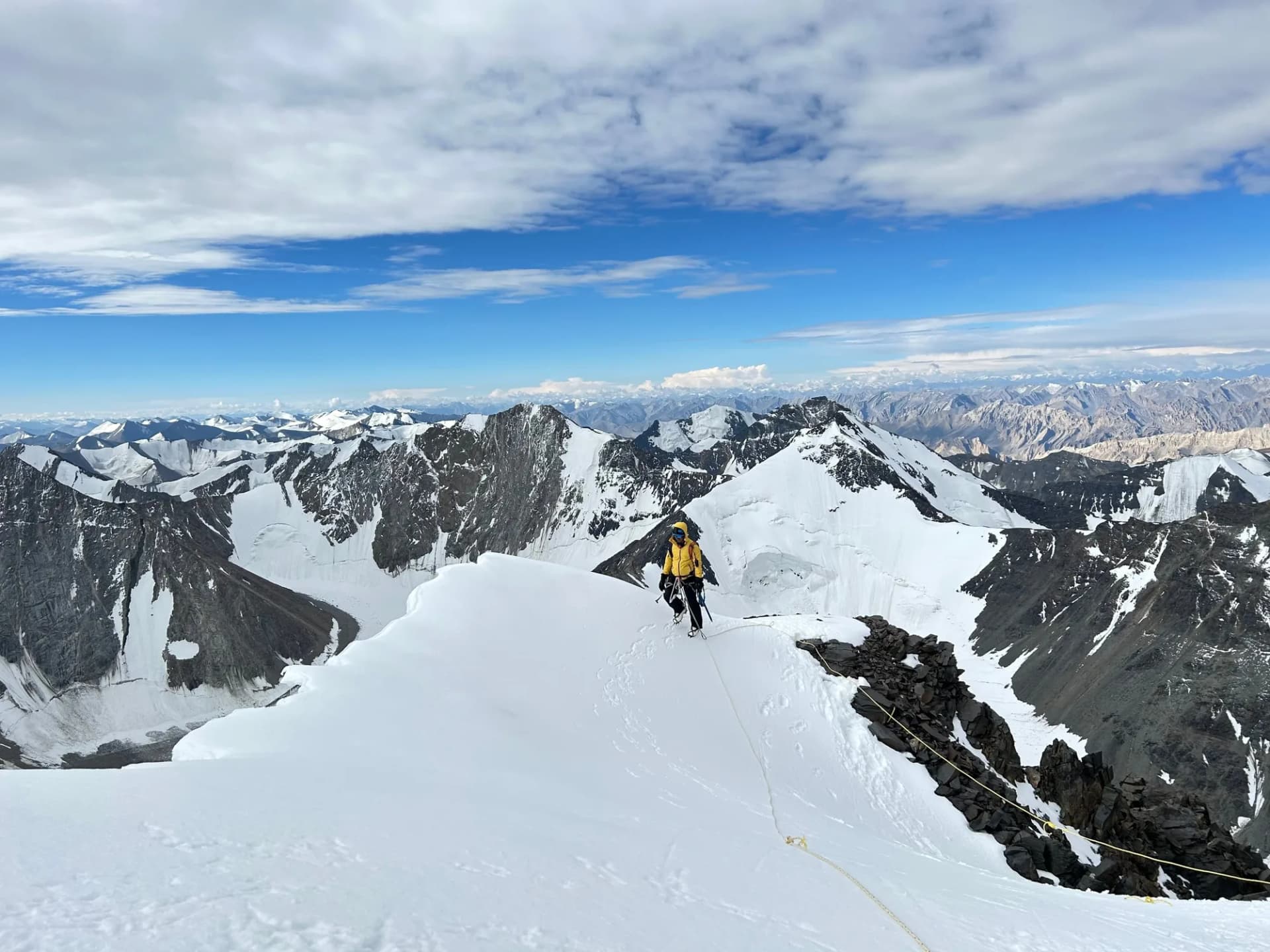
Rising to 6,400 m (20,997 ft), Kang Yatse I is the true summit of the Kang Yatse massif and one of Ladakh's most rewarding technical mountaineering objectives. While the approach follows the spectacular Markha Valley through Hemis National Park, the climb quickly transitions from trekking terrain into serious alpine mountaineering. Above base camp, climbers negotiate glaciated terrain, bergschrunds, steep snow and ice slopes, and an exposed summit ridge that demands confident movement on rope. Success requires proficiency with crampons, ice axe techniques, glacier travel, and crevasse rescue. Designed for experienced mountaineers, Kang Yatse I offers a natural progression beyond non-technical trekking peaks, combining classic Himalayan scenery with a demanding alpine ascent.
Ready to book? Compare verified operators for Kang Yatse 1 Peak Expedition — transparent pricing, no paid rankings.
Quick Facts
Duration
Max Altitude
Difficulty
Best Time
Trek Distance
Trail Atmosphere
Stargazing
Class 1 Dark Sky
Scent Profile
Silence Level
~10 dB
Vertigo Factor
8 / 10
Primarily a joint & muscle impact and cumulative fatigue challenge
An elite-level undertaking with extreme joint & muscle impact, cumulative fatigue, and altitude exposure. This route will push every dimension of your physical and mental endurance to the limit.
Iconic Spots
Yunam Summit (20,046 ft)
Getting There
Route to Base
Fly to Leh, 2 acclimatization days, drive to Chilling, then 4-day Markha Valley trek to Base Camp
Base Village
Nimaling
15,420 ft
Nearest Railhead
Jammu Tawi (JAT)
Nearest Airport
Kushok Bakula Rimpochee Airport, Leh (IXL)
Last ATM
Leh
Nearest Medical Facility
SNM Hospital, Leh
Mobile Signal
None.
Water Sources
Snow melting required at Base Camp.
Charging
Zero charging points after Keylong.
For Drivers
Road Condition
Manali to Darcha is excellent highway. Darcha to Bharatpur is steep, unpaved highway traversing sheer cliffs.
Keylong / Jispa
Trail Culinary & Diet
Don't miss the High altitude noodle soups for fast carb absorption
Buy specialized diet items at Manali
The Content & Remote Hub
No DronesStrictly banned due to extreme high altitude and proxy to military checkposts.Top Vlog Spots
Video Calls
none
Est. 0 Mbps
UPI Reliability
1/10
Guide Wisdom
Caution
The knife-edge ridge at 6,200m is no place for hesitation. Practise clipping and unclipping from fixed ropes during the training day until it is muscle memory.
Explore In Detail
Day by Day Itinerary
15-day route reaching 20,997ft. Covers 95km of varied terrain.
→ See full itinerary with altitude profileDifficulty & Fitness
Rated extreme. Steep ice wall of 55-65 degrees on the summit headwall. Requires full alpine technique.
→ See difficulty breakdown and fitness guideCost & Pricing
Packages range from ₹55,000 – ₹85,000. Inclusions and hidden costs vary by operator tier.
→ See full cost breakdownPermits and Regulations
IMF (Indian Mountaineering Foundation) peak booking fees apply because the altitude crosses 6000 meters. A heavily monitored police checkpoint at Darcha records all climber passport/Aadhar details.
Learn more about how we vet operators and ensure transparency on our why MountRoutes page.
Packing List
Expedition Clothing
- Summit Down Jacket (-25°C rating mandatory)
- Waterproof breathable alpine trousers
- Heavyweight thermal baselayers (Upper & Lower)
- Fleece mid-layers
- Balaclava/Face mask (To prevent frostbite from summit winds)
Footwear & Navigation
- Category C or D Expedition Boots (Must be extremely stiff-soled)
- Gaiters (For walking through the deep snow on the upper ridges)
- Micro-spikes (Operator usually provides crampons if ice is hard)
Wilderness Survival Gear
- Category 4 Glacier glasses (Mandatory)
- Trekking poles with snow baskets
- Heavy-duty expedition mitts (Not just gloves)
Flora & Fauna
Flora
Fauna
The high peaks of Lahaul are often seen as meditating ascetic monks by the locals, unbothered by the mortal world below.
— Local folklore
Spiritual & Cultural Significance
Low. Purely a mountaineering challenge.
🕐 Shrine Timings: N/A
Temple Protocols
Frequently Asked Questions
How is KY1 different from KY2?
KY2 is a PD grade snow slope. KY1 is AD+/D- with glacier crossing, bergschrund, and a fully exposed knife-edge summit ridge. It requires prior technical mountaineering experience — not just high-altitude trekking.
Can I attempt KY1 if I have only done KY2?
Technically yes if you had formal instruction during KY2. But ideally you should complete a Basic Mountaineering Course (BMC) from an IMF institute before attempting KY1.
What is the difference between Kang Yatse 1 and Kang Yatse 2?
Kang Yatse 1 (6,400m) is the true technical summit requiring advanced mountaineering skills, rope work, and ice climbing. Kang Yatse 2 (6,200m) is a trekking peak that is physically demanding but non-technical, making it more popular among trekkers.
Is Kang Yatse 1 a technical climb?
Yes, Kang Yatse 1 is a highly technical peak. The final push to the summit involves traversing a sharp, knife-edge ridge, navigating crevasses, and climbing steep ice walls requiring crampons, ice axes, and fixed ropes.
What kind of mountaineering experience is required for Kang Yatse 1?
Climbers must have prior experience on technical 6,000m peaks. Proficiency in using an ice axe, crampons, ascending/descending on fixed ropes, crevasse rescue techniques, and self-arrest is absolutely mandatory.
What is the best time for the Kang Yatse 1 expedition?
The optimal window for climbing Kang Yatse 1 is during the summer months in Ladakh, from mid-July to mid-September. During this time, the weather is relatively stable, and the snow conditions on the mountain are suitable for climbing.
What are the main challenges of the Kang Yatse 1 expedition?
The primary challenges include extreme altitude, harsh weather, objective hazards like hidden crevasses, and the technically demanding final summit ridge. The long approach march through the Markha Valley also requires excellent stamina.
Do I need special permits for climbing Kang Yatse 1?
Yes, Kang Yatse 1 requires a peak climbing permit from the Indian Mountaineering Foundation (IMF). A certified liaison officer or guide registered with the IMF must accompany the expedition.
What type of gear is essential for the Kang Yatse 1 summit?
Technical gear includes a harness, carabiners, ascender (jumar), descender, ice axe, C2/C3 crampons, a helmet, and mountaineering boots. High-altitude clothing like a down suit or heavy down jacket is also critical for survival.
How long does the Kang Yatse 1 expedition take?
The entire expedition typically takes 12 to 14 days from Leh. This includes a 5-6 day approach trek through the Markha Valley to aid acclimatization, establishing base and advanced camps, the summit push, and the return journey.
Other Expeditions Guides
Still deciding?
Compare routes side-by-side to find the perfect match for your fitness, dates, and budget.
Everything you need to know, in one place. Someone else in your group needs to see this.
Planning Kang Yatse 1 Peak Expedition?
Get route conditions, operator updates, and season windows before booking.
No spam. Only useful updates.
Ready to walk this route?
You’ve read the guide, now find the perfect local team to take you there. Compare our verified list of operators.
Compare verified operators