Essential Planning Guide
Valley of Flowers Trek — Complete Guide (2026)
Introduction
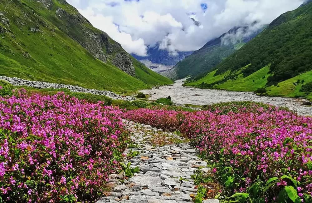
The Valley of Flowers is like a secret garden hidden high in the Garhwal Himalayas. It's a UNESCO World Heritage Site for a good reason—during the monsoon, this 87-square-kilometer valley transforms into a vibrant carpet of over 600 species of wildflowers. Imagine walking through fields of Blue Poppies, Cobra Lilies, and Brahma Kamals with the mist swirling around you. It's not about the summit views here; it's about the pure, botanical magic. Most trekkers pair this with a visit to Hemkund Sahib, the world's highest Gurudwara, which sits at a staggering 14,200 ft next to a glacial lake. The trail starts at Govindghat and uses the village of Ghangaria as a basecamp. If you're looking for a trek that feels more like a fairy tale than a high-altitude expedition, this is it. Just bring a good raincoat!
Ready to book? Compare verified operators for Valley of Flowers Trek — transparent pricing, no paid rankings.
Quick Facts
Duration
Max Altitude
Difficulty
Best Time
Trek Distance
Trail Atmosphere
Stargazing
Class 2 Dark Sky
Scent Profile
Silence Level
~40 dB
Vertigo Factor
1 / 10
Primarily a joint & muscle impact and cardio demand challenge
A demanding expedition dominated by extreme joint & muscle impact.
Iconic Spots
Pushpawati River Bridge
Margaret Legge Memorial
Hemkund Lake Reflections
Getting There
Route to Base
Haridwar / Rishikesh → Govindghat by road (10–11 hrs)
Govindghat → Pulna by shared jeep (4km)
Pulna → Ghangaria on foot (9km, 5–6 hrs)
Helicopter also available Govindghat → Ghangaria (weather dependent)
Base Village
Ghangaria (also called Gobind Dham)
10,200 ft
Nearest Railhead
Rishikesh
Nearest Airport
Jollygrant Airport
Last ATM
Joshimath (22km before Govindghat). No ATMs at Ghangaria.
Gear Rental
No gear rental at Ghangaria. Bring all gear from home or rent in Rishikesh / Haridwar before departure.
Nearest Medical Facility
Joshimath District Hospital
Mobile Signal
BSNL/Jio 4G carries intermittent signal in Ghangaria. Zero network coverage inside the National Park.
Water Sources
Pushpawati river flows through the valley; however, water should be filtered due to livestock presence upstream. Reliable natural springs at Ghangaria.
Charging
Ghangaria village only. Electricity is often erratic during heavy monsoon spells.
For Drivers
Road Condition
Main Badrinath highway is broad but sensitive to monsoon landslides near Lambagar and Joshimath.
Joshimath
Trail Culinary & Diet
Don't miss the Hemkund Langar Khichdi
Buy specialized diet items at Joshimath
The Content & Remote Hub
No DronesStrictly prohibited within National Park and near the Gurudwara.Top Vlog Spots
Video Calls
patchy
Est. 5 Mbps
UPI Reliability
3/10
Base WiFi Available
Don't miss this
Key point
This is one of the only Himalayan treks that is best visited during monsoon — rain is what brings the valley to life, not a reason to avoid it.
Caution
No gear rental at Ghangaria. Bring everything from home or rent in Rishikesh before departure — there is no backup option once you are on trail.
Explore In Detail
Day by Day Itinerary
6-day route reaching 14,107ft. Covers 16km of varied terrain.
→ See full itinerary with altitude profileDifficulty & Fitness
Rated challenging. Well-marked, maintained trail throughout. Govindghat to Ghangaria is a continuous uphill on a rocky forest path beside the river — tiring but straightforward. Ghangaria to Valley of Flowers is gentle with one steep section after the iron bridge. Ghangaria to Hemkund Sahib is the hardest section — steep and sustained climb on rocky terrain with no shade.
→ See difficulty breakdown and fitness guideCost & Pricing
Packages range from ₹8,000 – ₹18,000. Inclusions and hidden costs vary by operator tier.
→ See full cost breakdownPermits and Regulations
Entry to Valley of Flowers National Park requires a ticket purchased at the park gate near Ghangaria. Entry is restricted to daylight hours only — trekkers must exit the valley before sunset. No overnight camping is permitted inside the valley. National park rules prohibit picking flowers, lighting fires, and deviation from marked trails. Photography for personal use is permitted without restrictions.
Learn more about how we vet operators and ensure transparency on our why MountRoutes page.
Packing List
Rain & Waterproofing
- High-quality rain poncho or jacket (mandatory)
- Waterproof trekking pants or rain cover for pants
- Waterproof trekking shoes (not regular sneakers)
- Dry bags for camera, phone, and documents
- Backpack rain cover
Clothing
- 3 quick-dry t-shirts
- 2 trek pants or convertible hiking pants
- Mid-layer fleece
- Light down jacket (for Hemkund day)
- 3 pairs wool/synthetic socks
- Buff and warm hat for Hemkund
Gear
- Trekking poles (essential for Hemkund descent)
- Headlamp
- Sun protection (sunscreen SPF 50+, UV sunglasses)
- Personal medical kit + anti-nausea tablets
- Water purification tablets or filter
- Light 25–30L daypack for valley day
Flora & Fauna
Flora
Fauna
Historically known as Bhyundar Valley, villagers believed it was the playground of fairies who would spirit away anyone who wandered too deep.
— Local folklore
Spiritual & Cultural Significance
Hemkund Sahib is a major Sikh pilgrimage site.
🕐 Shrine Timings: 05:00 AM - 02:00 PM (Hemkund)
Temple Protocols
- •Head covering mandatory
- •Wash feet before entry
Festivals & Dates
Frequently Asked Questions
Is the Valley of Flowers accessible without a guide?
Yes. The trail from Govindghat to Ghangaria is a well-paved track used by thousands. Inside the park, the trail is marked. A guide is not mandatory but highly recommended for rare plant identification and safety.
Who discovered the Valley of Flowers?
British mountaineer Frank Smythe accidentally stumbled upon the valley in 1931 while returning from an expedition to Mt. Kamet. He later popularized it through his book "The Valley of Flowers".
Are there leeches on the trail?
Yes, especially during peak monsoon (July-August) on the forest sections. Wearing full-length socks and carrying salt or tiger balm is effective for removal.
How difficult is the climb to Hemkund Sahib?
The 6km climb from Ghangaria to Hemkund Sahib (14,330 ft) is very steep but well-paved. It is significantly more taxing than the valley walk; mules are available for those with physical constraints.
When exactly does the park open and close?
The park typically opens on June 1st and closes in mid-October. The best floral density is seen between July 15th and August 15th.
Can this trek be done with children?
Children aged 8+ with decent walking stamina can manage the valley. However, the high altitude of Hemkund Sahib (14,000 ft+) requires careful monitoring for AMS.
What species of flowers can I expect to see?
Over 500 species bloom here, including the rare Brahma Kamal, Blue Poppy, Cobra Lily, and various Himalayan orchids and primulas.
Are there places to eat inside the National Park?
No. Eating and camping inside the park are strictly prohibited. Trekkers must carry a packed lunch and water from Ghangaria and bring back all their trash.
What weather or flood risks (GLOF) exist?
The Pushpawati River can swell during heavy rain. Operators and Forest Rangers monitor levels closely; trekking is restricted during extreme weather alerts.
Is there mobile connectivity in Ghangaria?
BSNL is the only network with sporadic signal. Most guest houses have satellite-linked landlines available for essential calls.
How do I choose the best operator via MountRoutes?
MountRoutes compares verified operators based on accommodation quality in Ghangaria, group size, and safety protocols. Use our filters to find the right comfort-to-cost ratio.
What is usually included in the trek cost?
Standard packages include guesthouse stays in Ghangaria, all meals, forest permits, and a local guide. Transport from Rishikesh and mule hire are usually auxiliary costs.
Other Treks Guides
Still deciding?
Compare routes side-by-side to find the perfect match for your fitness, dates, and budget.
Everything you need to know, in one place. Someone else in your group needs to see this.
Planning Valley of Flowers Trek?
Get route conditions, operator updates, and season windows before booking.
No spam. Only useful updates.
Ready to walk this route?
You’ve read the guide, now find the perfect local team to take you there. Compare our verified list of operators.
Compare verified operators