Detailed Route
Valley of Flowers Trek Itinerary — Day by Day Route & Camps
Standard RouteThis is the standard mountain pacing for this trek. Specific operators may add an acclimatization day or alter the starting point. Check individual operator schedules for their exact logistics.
Duration
6 Days
Total Distance
16 KM
Max Altitude
14,107 FT
Trek Type
linear
Permits Required Before You Go
Permit Cost
Where to Get
National Park gate at Valley of Flowers entrance (Day 3). Paid per person per day of entry.
Documents
Aadhar Card or valid government ID
Foreign Nationals
Foreign nationals pay ₹600 per day entry fee. Same documents required.
Foreigner Process
Permit issued at National Park gate; valid for 3 days.
Nearest Embassy Hub
Dehradun
Day by Day Breakdown
Drive: Haridwar / Rishikesh to Govindghat
Long drive along the Alaknanda river passing all five Prayags. Last ATM at Joshimath — withdraw cash here. Night halt at Govindghat. Acclimatisation day.
Key Landmarks
Trek: Govindghat (Pulna) to Ghangaria
5km shared jeep ride from Govindghat to Pulna is the actual trek start. Continuous ascent alongside the roaring Pushpawati river. Well-marked trail with tea shops and snack stalls throughout. Ghangaria is the base for all explorations — Valley of Flowers and Hemkund Sahib both accessible from here. Helicopter service available from Govindghat to Ghangaria at extra cost (weather dependent).
Key Landmarks
Staying At
Day Trek: Ghangaria to Valley of Flowers and Return
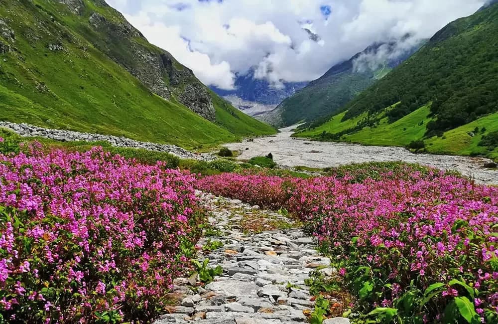
Entry ticket required at National Park gate — collected per person. Trail begins gently then becomes steep after the iron bridge over Pushpawati river. Valley stretches 8km long — you do not need to walk the entire length. Peak bloom mid-July to mid-August: blue poppy, brahma kamal, primulas, orchids, balsam, cobra lily. No food or camping allowed inside the valley. Ponies NOT permitted inside — only porters. Return to Ghangaria for night.
Key Landmarks
Staying At
Day Trek: Ghangaria to Hemkund Sahib and Return
Toughest day of the trek. Steep sustained climb from 10,200ft to 14,107ft. Start early — weather at Hemkund changes rapidly, clear mornings are common, afternoons often cloudy. Ponies and porters available on this day. Brahma Kamal flowers visible on approach. Glacial lake surrounded by seven peaks. Sikh pilgrimage site — free langar (community meal) available. Return to Ghangaria same evening.
Key Landmarks
Staying At
Trek: Ghangaria to Pulna, Drive to Govindghat and then Joshimath / Pipalkoti
Descend the same trail back to Pulna. 4km shared jeep from Pulna to Govindghat. Drive to Joshimath or Pipalkoti for night halt. Some operators offer optional Badrinath visit from here.
Key Landmarks
Drive: Joshimath / Pipalkoti to Haridwar / Rishikesh
Return drive. Reach Haridwar / Rishikesh by evening 6–7 PM. Book onward trains / buses after 8:30 PM to be safe.
Key Landmarks
Trek Extensions & Add-ons
Badrinath Pilgrimage
+1 Day25km drive from Govindghat to the holy temple of Badrinath.
Also on this trek
Ready to book? Compare verified operators for Valley of Flowers Trek — transparent pricing, no paid rankings.
Still deciding?
Compare routes side-by-side to find the perfect match for your fitness, dates, and budget.
Day by day, camp by camp. Send this to your group so everyone's on the same page.
Love this itinerary?
Find operators who follow this exact route with verified acclimatization days.
Find matching operators