Essential Planning Guide
Panchachuli Base Camp Trek — Complete Guide (2026)
Introduction
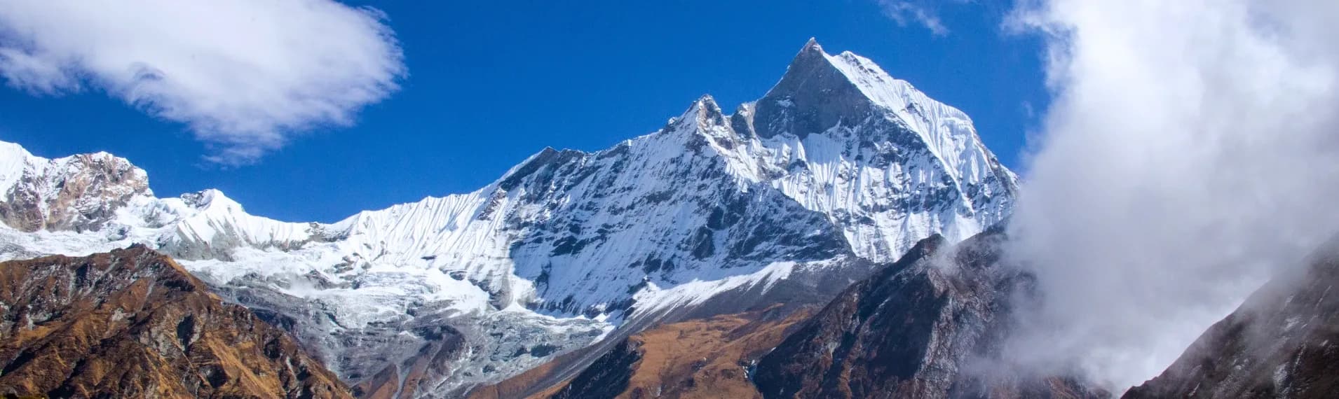
The Panchachuli Base Camp trek penetrates deep into the intensely remote Darma Valley of Kumaon, sitting parallel to the Nepal and Tibet borders. The term 'Panchachuli' refers to five distinct snow-capped peaks that dominate the eastern skyline, historically believed to be the five cooking hearths (chulhas) used by the Pandavas on their final journey to heaven. Unlike the heavily commercialized Garhwal treks, this route remains pristine and culturally raw, passing through ancient Bhotia tribal villages like Duktu and Dantu. The trek traces the raging Dhauliganga river upward, transitioning from dense alpine forests into a massive, wind-swept glacial bowl directly beneath the five staggering peaks. Because of extensive recent border road development, the actual walking distance has been drastically reduced, transforming what used to be a grueling 12-day expedition into an highly accessible, visually stunning 8-day itinerary suitable for determined beginners.
Ready to book? Compare verified operators for Panchachuli Base Camp Trek — transparent pricing, no paid rankings.
Quick Facts
Duration
Max Altitude
Difficulty
Best Time
Trek Distance
Trail Atmosphere
Stargazing
Class 1 Dark Sky
Scent Profile
Silence Level
~15 dB
Vertigo Factor
3 / 10
Primarily a joint & muscle impact and cardio demand challenge
A capable trekker's route that balances joint & muscle impact and cardio demand.
Iconic Spots
Duktu Sunrise
Getting There
Route to Base
Train to Kathgodam, followed by an 11-hour shared jeep ride tracking the Nepal border up to Dharchula
Base Village
Dharchula / Urthing
3,000 ft
Last ATM
Dharchula
Nearest Medical Facility
Dharchula Main Hospital
Mobile Signal
Total dark zone past Tawaghat.
Water Sources
Running streams are easily accessible along the path to Base camp.
Charging
Duktu homestays may have basic solar charging on sunny days.
For Drivers
Road Condition
Kathgodam to Dharchula is smooth border highway. Dharchula to Urthing is a terrifying, unpaved cliff road.
Dharchula
Trail Culinary & Diet
Don't miss the Munsiyari Rajma
Buy specialized diet items at Dharchula
The Content & Remote Hub
No DronesStrictly illegal due to Darma valley border significance.Top Vlog Spots
Video Calls
none
Est. 0 Mbps
UPI Reliability
1/10
Base WiFi Available
Guide Wisdom
Caution
The wind off the Panchachuli glacier begins at 1 PM every day like clockwork. Do your Zero point hike early and be back in Duktu by lunch.
Explore In Detail
Day by Day Itinerary
8-day route reaching 13,975ft. Covers 34km of varied terrain.
→ See full itinerary with altitude profileDifficulty & Fitness
Rated moderate. The actual trekking trail is highly manageable—mostly gentle dirt paths through villages. The difficulty historically came from the distance, which the new roads have effectively neutralized.
→ See difficulty breakdown and fitness guideCost & Pricing
Packages range from ₹15,000 to ₹19,000. Inclusions and hidden costs vary by operator tier.
→ See full cost breakdownPermits and Regulations
Heavily restricted. An Inner Line Permit (ILP) is required from Dharchula. You must carry valid Police Verification and an Aadhar card. Drones are strictly banned due to border proximity. Foreign nationals face a highly complex application process and are often denied.
Learn more about how we vet operators and ensure transparency on our why MountRoutes page.
Packing List
High-Alpine Clothing
- Heavy down jacket (Duktu village and base camp experience extreme wind chill off the glacier)
- Fleece mid-layers
- Windproof/Waterproof Hardshell Jacket
Footwear
- Waterproof mid-ankle trekking boots (The trail is well defined but crosses several glacial melt streams)
- Gaiters (For crossing residual snow in May/June)
- 3 pairs of merino wool socks
Photography & Navigation
- High quality UV 400 Sunglasses (The snow glare from the five peaks is intense)
- Wide-angle camera lens (Getting all five peaks in one frame requires extreme wide angles)
Flora & Fauna
Flora
Fauna
The last cooking meal of the five Pandava brothers before reaching heaven was cooked on the five peaks, hence the five distinct triangular summits.
— Local folklore
Spiritual & Cultural Significance
Deep Shaivite and Mahabharata mythology runs through the Darma valley.
🕐 Shrine Timings: N/A
Temple Protocols
Frequently Asked Questions
Is the Panchachuli Base Camp trek difficult?
It is a strictly moderate trek. The new border roads have eliminated the punishing lower-valley hikes, meaning you only walk the most scenic, high-altitude sections. However, the peak altitude is nearly 14,000 ft, so acclimatization is key.
How long has the trekking distance been reduced?
Historically, you walked all the way from Tawaghat. Now, you can drive almost entirely to Urthing or even Baaling, reducing the actual trekking days from 8 days to just 3-4 days.
What is the peak altitude?
The Base Camp (Zero Point) is situated at approx 13,975 ft (4,260m).
Are there KMVN rest houses available?
Yes. KMVN provides basic huts at Dharchula, Tawaghat, and some upper villages. Homestays in Duktu and Dantu have also proliferated rapidly.
Which peaks will I see clearly?
The entire Panchachuli massif (Peaks I to V) is visible directly from your sleeping tents at Duktu. You also see glimpses of the Rajrambha and Chaudhara peaks.
Is an Inner Line Permit required?
Yes. The Darma Valley runs parallel to the Nepal and Tibet borders. Permits are mandatory and issued by the SDM office in Dharchula.
Where does the trek start?
The journey starts from Kathgodam/Haldwani, moving to Dharchula. The physical walk typically starts near the villages of Urthing or Baaling.
Is mobile network available?
Jio/BSNL signals are highly erratic past Dharchula. Assume complete zero connectivity from Urthing onwards.
What is the cultural significance of the valley?
The Darma Valley is inhabited by the resilient Byansi and Darmiya tribes (Bhotias) who maintained the trans-Himalayan trade routes for centuries before 1962.
Can I do this trek in monsoon?
Absolutely not. The road from Dharchula into the Darma valley is completely destroyed by landslides during July and August.
Other Treks Guides
Still deciding?
Compare routes side-by-side to find the perfect match for your fitness, dates, and budget.
Everything you need to know, in one place. Someone else in your group needs to see this.
Planning Panchachuli Base Camp Trek?
Get route conditions, operator updates, and season windows before booking.
No spam. Only useful updates.
Ready to walk this route?
You’ve read the guide, now find the perfect local team to take you there. Compare our verified list of operators.
Compare verified operators