Detailed Route
Panchachuli Base Camp Trek Itinerary — Day by Day Route & Camps
Starts from Dharchula/Tawaghat, walking through remote tribal villages to the base of the Panchachuli glacier.
Standard RouteThis is the standard mountain pacing for this trek. Specific operators may add an acclimatization day or alter the starting point. Check individual operator schedules for their exact logistics.
Duration
8 Days
Total Distance
34 KM
Max Altitude
13,975 FT
Trek Type
linear
Permits Required Before You Go
Permit Cost
Where to Get
Dharchula SDM Office
Documents
Aadhar Card, Medical auto-declaration, Police verification
Foreign Nationals
Extremely difficult to obtain without a registered Indian agency. Denials happen frequently.
Foreigner Process
Highly complex. Requires inner-line clearance filed months in advance.
Nearest Embassy Hub
New Delhi
Day by Day Breakdown
Drive Kathgodam to Dharchula
A massive 11-hour drive through the Kumaon hills, constantly tracking the Kali river which serves as the natural border with Nepal. Dharchula is a bustling, low-altitude border town.
Key Landmarks
Staying At
Permits & Drive Dharchula to Urthing / Baaling
After securing ILPs in the morning, taking local 4x4 jeeps up the newly cut cliff-roads into the deep Darma valley. The road is incredibly rough. Reach the idyllic alpine village of Baaling.
Key Landmarks
Staying At
Trek Baaling to Duktu
The actual walking begins. Trek through beautiful Birch (Bhojpatra) and conifer forests. As you emerge into the higher valley, the full Panchachuli massif suddenly explodes into view. Duktu is a picturesque tribal village situated directly opposite the peaks.
Key Landmarks
Staying At
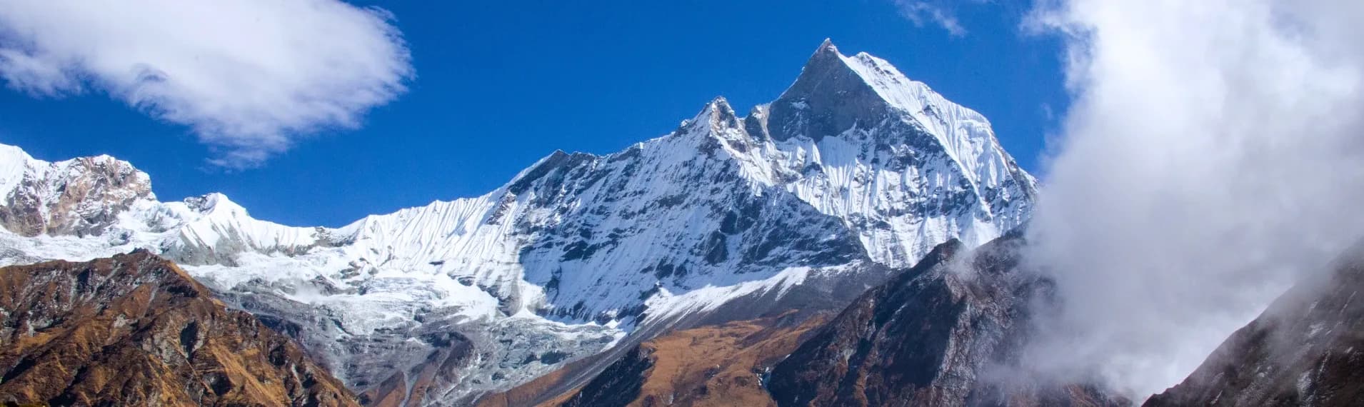
Trek Duktu to Panchachuli Base Camp (Zero Point) & Return
The apex day. Ascend a steady trail up the huge glacial moraine. Standing at Zero Point (approx 14k ft), the sheer scale of the five peaks is overwhelming. Glacial winds here are fierce. Hike back down to Duktu for the night.
Key Landmarks
Staying At
Explore Dantu Village & Darma Valley
A relaxed day to mitigate altitude fatigue. Cross the stream to the neighboring village of Dantu. Explore the ancient wooden architecture, the local amaranth fields, and interact with the remarkably hospitable Byansi locals.
Key Landmarks
Staying At
Trek Dantu to Urthing / Baaling
Begin the retreat. A fast descent back down the same trail you climbed on Day 3, leaving the high alpine tundra and re-entering the thicker forests near Urthing/Baaling.
Key Landmarks
Staying At
Drive Urthing / Baaling to Dharchula
Board the local jeeps again to navigate the terrifying gorge roads back down to the safety and thick oxygen of Dharchula.
Key Landmarks
Staying At
Drive Dharchula to Kathgodam
The exhaustive final driving day back to the railway station, concluding the expedition.
Key Landmarks
Trek Extensions & Add-ons
Sin La Pass Exploration
+4 DaysMountaineers with technical gear often attempt the grueling 18k ft Sin La pass to cross over into the neighboring Byans Valley (Chialekh/Gunji).
Also on this trek
Ready to book? Compare verified operators for Panchachuli Base Camp Trek — transparent pricing, no paid rankings.
Still deciding?
Compare routes side-by-side to find the perfect match for your fitness, dates, and budget.
Day by day, camp by camp. Send this to your group so everyone's on the same page.
Love this itinerary?
Find operators who follow this exact route with verified acclimatization days.
Find matching operators