Essential Planning Guide
Kagbhushandi Tal Trek — Complete Guide (2026)
Introduction
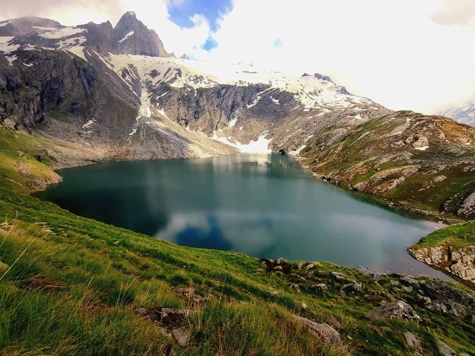
Kagbhushandi Tal is a brilliantly emerald-green, high-altitude alpine lake (14,100 ft) hidden deep within the treacherous folds of the Garhwal Himalayas. Situated at the base of the towering Hathi Parbat (Elephant Peak), it is utterly steeped in Hindu mythology; legends state that the sage Kakbhushundi resides here in the form of a crow, discussing cosmic truths with Garuda. While it shares the exact same starting point (Govindghat / Bhyundar village) as the hyper-commercialized Valley of Flowers, the trail to Kagbhushandi veers sharply off into complete isolation. It is a grueling, technically demanding wilderness trek requiring trekkers to navigate pathless moraine, massive boulder fields, and cross the highly exposed Kankul Khal pass (15,200 ft). Punishing elevation profiles, extreme weather volatility, and thick regional bear populations ensure it remains a trail strictly for advanced, highly self-sufficient trekkers.
Ready to book? Compare verified operators for Kagbhushandi Tal Trek — transparent pricing, no paid rankings.
Quick Facts
Duration
Max Altitude
Difficulty
Best Time
Trek Distance
Trail Atmosphere
Stargazing
Class 1 Dark Sky
Scent Profile
Silence Level
~10 dB
Vertigo Factor
3 / 10
Primarily a joint & muscle impact and altitude exposure challenge
A demanding expedition dominated by extreme joint & muscle impact.
Iconic Spots
Kankul Khal Descent
Getting There
Route to Base
Bus/Cab from Rishikesh directly up the NH-58 Badrinath highway
Base Village
Bhyundar / Govindghat
8,500 ft
Last ATM
Joshimath
Nearest Medical Facility
Joshimath Army Hospital
Mobile Signal
Total dark zone for 5 days.
Water Sources
Flowing streams near camps, but strictly treat/boil everything.
Charging
Zero charging after Govindghat.
For Drivers
Road Condition
The NH-58 is very well maintained but heavily trafficked by Badrinath pilgrims.
Joshimath
Trail Culinary & Diet
Don't miss the N/A
Buy specialized diet items at Joshimath
The Content & Remote Hub
No DronesStrictly illegal inside Nanda Devi Biosphere and near Badrinath airspace.Top Vlog Spots
Video Calls
none
Est. 20 Mbps
UPI Reliability
4/10
Base WiFi Available
Guide Wisdom
Key point
Crows (Kakbhushundi) literally circle the lake daily. Do not feed them or disturb the area, as local porters hold the location in extreme spiritual reverence.
Explore In Detail
Day by Day Itinerary
7-day route reaching 15,000ft. Covers 58km of varied terrain.
→ See full itinerary with altitude profileDifficulty & Fitness
Rated challenging. Extremely rugged. Once you leave the tree line on Day 3, there is no defined path. You are walking over raw glacial moraine and massive boulders to reach the pass.
→ See difficulty breakdown and fitness guideCost & Pricing
Packages range from ₹16,000 to ₹22,000. Inclusions and hidden costs vary by operator tier.
→ See full cost breakdownPermits and Regulations
Permits from the Nanda Devi Biosphere Forest Department at Joshimath/Govindghat are required. Because it is highly remote, the DFO often requires proof of a certified guide before issuing.
Learn more about how we vet operators and ensure transparency on our why MountRoutes page.
Packing List
Advanced Navigational Gear
- Offline GPS device (The trail is non-existent past Raj Kharak)
- Double trekking poles (Vital for the boulder hopping over the glacier)
- Microspikes (Crucial for crossing Kankul Khal in early summer)
High-Alpine Clothing
- Gore-Tex Hardshell pants and jacket (The Bhyundar valley channels massive, sudden thunderstorms)
- Premium Down Jacket (-15°C rating)
- Waterproof gaiters
Survival Essentials
- Expedition Grade Sleeping Bag (-15°C limit)
- Complete First Aid / AMS kit (Diamox)
- Water purification tablets (Glacial runoff must be treated)
Flora & Fauna
Flora
Fauna
Legend has it that Lord Rama discussed cosmic truths with Kakbhushundi (immortal crow) at this very lake. Dropping garbage here is a severe local offense.
— Local folklore
Spiritual & Cultural Significance
Believed to be the cosmic residence of Kakbhushundi (crow sage).
🕐 Shrine Timings: N/A
Temple Protocols
- •Complete sobriety
- •Leave no trace purity
Frequently Asked Questions
Is this the same trail as the Valley of Flowers?
Only for the first day. You drive/trek from Govindghat to Bhyundar village, but instead of continuing towards Ghangaria, you cut sharply East into a completely wild, unmapped valley.
Why is the lake so famous?
Aside from its vivid emerald color, mythology dictates that it is the home of Kakbhushundi (the crow sage). You will frequently see large ravens and crows congregating around the freezing waters, adding to the mystique.
Can beginners do this?
Absolutely not. This is a severe wilderness trek. There are no tea houses, no defined trails on the upper sections, and it requires crossing a 15,200 ft pass over massive boulders.
Is there mobile connectivity?
None. Your phone will lose signal permanently after leaving the main Bhyundar/Govindghat corridor.
Are there bears?
Yes. The dense oak and rhododendron forests below the tree line are prime Himalayan Black Bear territory. Do not keep food in your tents.
Can I do it alone?
It is highly dangerous to attempt solo. The path over Kankul Khal is unmarked boulder-scree. A local guide from Bhyundar or Joshimath is essentially mandatory to find the route.
What peaks will I see?
The lake sits directly beneath the massive rock wall of Hathi Parbat. You also get incredible views of Chaukhamba, Neelkanth, and Nar-Narayan peaks.
Are mules allowed?
Mules cannot cross the boulders over Kankul Khal. You must hire specialized local porters for the upper sections.
Where does the trek end?
It is typically a crossover. You start at Bhyundar, cross Kankul Khal to Kagbhushandi Tal, and descend the other side down the Farkia valley to exit near Vishnuprayag/Joshimath.
Is camping equipment provided?
There are no camps. Your expedition must carry all logistical gear, food, and fuel from the roadhead.
Other Treks Guides
Still deciding?
Compare routes side-by-side to find the perfect match for your fitness, dates, and budget.
Everything you need to know, in one place. Someone else in your group needs to see this.
Planning Kagbhushandi Tal Trek?
Get route conditions, operator updates, and season windows before booking.
No spam. Only useful updates.
Ready to walk this route?
You’ve read the guide, now find the perfect local team to take you there. Compare our verified list of operators.
Compare verified operators