Essential Planning Guide
Panpatia Col Expedition — Complete Guide (2026)
Introduction
The Panpatia Col (approximately 18,400 ft / 5,610m) is one of the most sacred and least-trekked high crossings in the Garhwal Himalaya — a glacier col connecting the Kedarnath valley (one of Hinduism's holiest sites) with the Badrinath valley (another supreme pilgrimage destination) across the high Kedarnath-Badrinath divide. It has historically been called 'the Holy Grail' of Garhwal trekking because it achieves something extraordinary: a physical link between two of India's most significant sacred sites across the highest complete crossing available on foot. The approach from the Kedarnath side passes above the Kedarnath temple into the upper Mandakini glacial basin — terrain almost never seen by the millions of Kedarnath pilgrims below, a world of permanent snow and hanging glaciers that exists in surreal proximity to one of India's most crowded pilgrimage sites. The crossing emerges near Badrinath on the far side, completing a trans-valley crossing of exceptional cultural and physical significance. This is a mountaineering-level high-glacier crossing requiring rope team, crampons, and expedition experience.
Ready to book? Compare verified operators for Panpatia Col Expedition — transparent pricing, no paid rankings.
Quick Facts
Duration
Max Altitude
Difficulty
Best Time
Trek Distance
Trail Atmosphere
Stargazing
Class 1 Dark Sky
Scent Profile
Silence Level
~0 dB
Vertigo Factor
5 / 10
Primarily a joint & muscle impact and cumulative fatigue challenge
A demanding expedition with extreme joint & muscle impact, cumulative fatigue, and altitude exposure. This route will push every dimension of your physical and mental endurance to the limit.
Iconic Spots
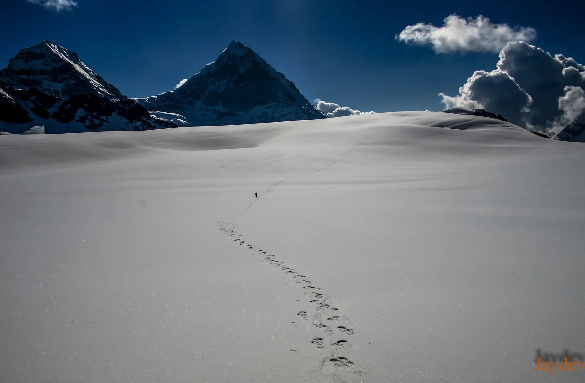
Panpatia Col Panorama (18,400 ft)
Getting There
Route to Base
Haridwar/Rishikesh → Gaurikund → Kedarnath (16 km on foot or pony)
Well-organized pilgrimage infrastructure
Base Village
Kedarnath (approach) / Badrinath (exit)
11,755 ft
Nearest Railhead
Dehradun (DDN) / Haridwar (HW)
Nearest Airport
Jolly Grant Airport, Dehradun (DED)
Last ATM
Gaurikund (Kedarnath side). Badrinath (exit).
Nearest Medical Facility
Kedarnath temple medical camp (on approach). Badrinath hospital (exit).
Mobile Signal
Kedarnath (limited). Zero on glacier.
Water Sources
Snow and glacier melt from Day 4. Carry filter system.
Charging
Kedarnath temple complex (on approach). Zero on glacier.
For Drivers
Road Condition
Haridwar to Gaurikund is pilgrim road — functional but crowded in season.
Rudraprayag / Gaurikund
Trail Culinary & Diet
Don't miss the Kedarnath prasad panchamrit before departure — the temple's sacred offering
Buy specialized diet items at Kedarnath (full vegetarian only — pilgrimage zone). Gaurikund for limited options.
The Content & Remote Hub
No DronesWildlife sanctuary restriction.Top Vlog Spots
Video Calls
satellite_only
Est. 0 Mbps
UPI Reliability
3/10
The Sacred Geography
Key point
Standing at the Panpatia Col at 18,400 ft — one of the highest accessible cols in the Garhwal Himalaya — you can simultaneously see the drainage toward Kedarnath (Shiva's domain) and toward Badrinath (Vishnu's domain) separated by a single col. This is the physical summit of Hinduism's sacred geography.
Explore In Detail
Day by Day Itinerary
13-day route reaching 17,257ft. Covers 36km of varied terrain.
→ See full itinerary with altitude profileDifficulty & Fitness
Rated challenging. Moraine, glacier, crevasse field, fixed rope, col wall. Full expedition terrain.
→ See difficulty breakdown and fitness guideCost & Pricing
Packages range from ₹80,000 to ₹1,50,000. Inclusions and hidden costs vary by operator tier.
→ See full cost breakdownPermits and Regulations
Kedarnath Wildlife Sanctuary Permit mandatory (DFO Rudraprayag). High altitude glacial trekking permit. No camping within the inner sanctuary zone without explicit permit.
Learn more about how we vet operators and ensure transparency on our why MountRoutes page.
Packing List
18,400 ft Glacial Col
- Double mountaineering boots rated to -25C
- 12-point crampons — fully rigid frame
- Ice axe with full arrest training
- Rope team kit: 50m 8mm dynamic rope, harnesses, locking carabiners
- Snow anchors: pickets x4 per team
10-Day Glacial Expedition
- Expedition sleeping bag (-30C)
- 4-season dome tent rated for glacial wind at 18,000 ft
- Satellite phone / PLB mandatory
- Pulse oximeter for daily monitoring
Flora & Fauna
Flora
Fauna
In Garhwali Brahmin tradition, the Panpatia Col is where the sage Panpa meditated after completing a circuit of both Kedarnath and Badrinath — his tapasya at the col created a permanent energy bridge between the two sacred sites.
— Local folklore
Spiritual & Cultural Significance
Physically links Kedarnath (Shiva) and Badrinath (Vishnu) — two of the four Char Dham pilgrimage sites — at their glacial divide.
🕐 Shrine Timings: Kedarnath Temple: 5am-3pm and 5pm-9pm (pilgrimage season).
Temple Protocols
- •Full vegetarian and alcohol-free zone
- •Dress modestly at Kedarnath temple
- •Seek pujari's blessing before glacier departure
Festivals & Dates
Frequently Asked Questions
Is this a permitted route?
Yes, but the glacial zone near Kedarnath is within a restricted sanctuary. Forest/sanctuary permit from Kedarnath Wildlife Sanctuary is required. The route is legally accessible with correct permits.
How many people cross Panpatia Col per year?
Perhaps 5-15 successful crossings per year in good conditions. One of India's rarest crossing achievements.
What makes this crossing 'holy'?
The cultural significance of physically connecting two of the four Char Dham pilgrimage sites (Kedarnath + Badrinath) on foot via the high glacier divide is considered a supreme pilgrimage accomplishment in Garhwali Brahmin and Shaivite tradition.
What is the technical difficulty?
The col approach involves sustained 40-50 degree glacier sections with crevasse zones. Fixed rope mandatory on the summit approach. This is a serious high-altitude mountaineering objective.
What is the Kedarnath approach like?
The approach from Kedarnath goes above the temple complex into the upper sanctum of the Kedarnath mountain bowl — terrain of extraordinary spiritual atmosphere and glacial grandeur that almost no visitor to Kedarnath ever sees.
What are the views from the col?
360-degree panorama of the entire Kedar-Badrinath massif — Kedarnath (6,940m), Chaukhamba (7,138m), Badrinath (7,198m), and the full Gangotri range visible on exceptionally clear days.
When was this route first documented?
Historical accounts suggest ancient ascetic crossings. In the modern era, early Himalayan Club expeditions documented the route in the 1930s-40s. Eric Shipton's Himalayan accounts reference the col area.
What is the safest season?
Late May to early June (after Kedarnath pilgrimage route opens, before monsoon) and September (post-monsoon window before October snow).
Is acclimatization at Kedarnath helpful?
Extremely — Kedarnath temple at 11,755 ft is an excellent acclimatization base. Spend 3 nights there before starting.
What permits are needed?
Kedarnath Wildlife Sanctuary permit + Forest Department high altitude trekking permit. Arranged via DFO Rudraprayag/Chamoli.
Other Expeditions Guides
Still deciding?
Compare routes side-by-side to find the perfect match for your fitness, dates, and budget.
Everything you need to know, in one place. Someone else in your group needs to see this.
Planning Panpatia Col Expedition?
Get route conditions, operator updates, and season windows before booking.
No spam. Only useful updates.
Ready to walk this route?
You’ve read the guide, now find the perfect local team to take you there. Compare our verified list of operators.
Compare verified operators