Essential Planning Guide
Borasu Pass Expedition — Complete Guide (2026)
Introduction
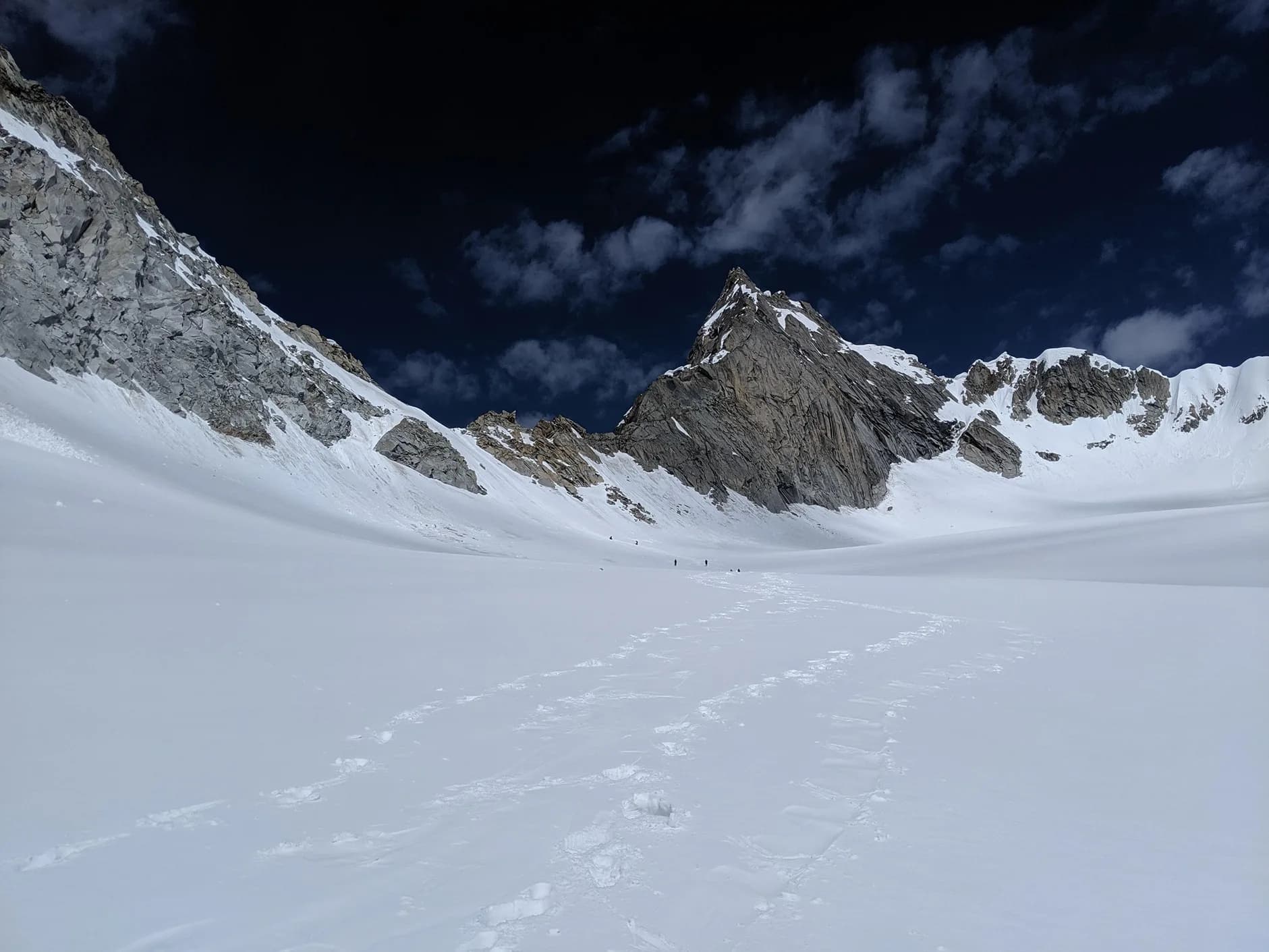
Borasu Pass is a legendary high-altitude crossover trek that connects the Tons Valley in Uttarakhand with the Baspa Valley in Himachal Pradesh. Standing at 17,880 ft, it is one of the highest and most formidable gateways between two distinct Himalayan cultures. The trek begins in the ancient village of Sankri, winding through the Har Ki Dun valley before diverging towards the vast, glaciated terrain of the Borasu glacier. It is a journey of extreme contrasts—from the lush green forests and wooden temples of the Garhwal to the stark, snow-swept mountain desert of the Kinnaur region. Crossing the Borasu Pass is a rite of passage for seasoned trekkers, offering a unique perspective on the physical and cultural divide of the North Indian Himalayas.
Ready to book? Compare verified operators for Borasu Pass Expedition — transparent pricing, no paid rankings.
Quick Facts
Duration
Max Altitude
Difficulty
Best Time
Trek Distance
Trail Atmosphere
Stargazing
Class 1 Dark Sky
Scent Profile
Silence Level
~15 dB
Vertigo Factor
4 / 10
Primarily a joint & muscle impact and altitude exposure challenge
A capable trekker's route with extreme joint & muscle impact, altitude exposure, and cumulative fatigue. This route will push every dimension of your physical and mental endurance to the limit.
Iconic Spots
Borasu Summit Crest
Chitkul Village
Getting There
Route to Base
8-hour drive from Dehradun to Sankri
12-hour drive back from Chitkul
Base Village
Sankri (UK) / Chitkul (HP)
6,400 ft
Nearest Railhead
Rishikesh
Nearest Airport
Jollygrant Airport
Last ATM
Purola (UK side). No reliable ATMs beyond.
Nearest Medical Facility
Chitkul PHC / Reckong Peo Hospital
Mobile Signal
Exceptional Jio/BSNL at Chitkul terminal. Strong 4G at Sankri. Zero coverage throughout the pass crossing (3-4 high-altitude days).
Water Sources
Abundant glacial melt from Tons and Baspa tributaries. Reliable springs at Osla, Har Ki Dun, and Borasu base camps.
Charging
Available at Sankri (Base) and Chitkul (End). Zero charging availability on the 7-day crossing.
For Drivers
Road Condition
Shimla to Chitkul road is mostly excellent but subject to shooting stone delays near Wangtoo.
Sangla / Purola
Trail Culinary & Diet
Don't miss the Himachali Siddu
Buy specialized diet items at Shimla / Dehradun
The Content & Remote Hub
No DronesStrictly prohibited due to immediate proximity to the International Border and ITBP outposts.Top Vlog Spots
Video Calls
base-only
Est. 20 Mbps
UPI Reliability
4/10
Base WiFi Available
The Cross-State Giant
Key point
Borasu Pass is the only high-altitude crossing that connects the distinct cultures of Garhwal and Kinnaur in a single 12-hour walk.
Key point
The Swargarohini wall visible from Har Ki Dun is the very peak where legend says only Yudhishthira reached heaven alive.
Explore In Detail
Day by Day Itinerary
8-day route reaching 17,881ft. Covers 66km of varied terrain.
→ See full itinerary with altitude profileDifficulty & Fitness
Rated moderate. Highly technical. Mix of forest, meadows, long moraine walks, and a 45-60 degree ice-wall ascent.
→ See difficulty breakdown and fitness guideCost & Pricing
Packages range from ₹20,000 – ₹35,000. Inclusions and hidden costs vary by operator tier.
→ See full cost breakdownPermits and Regulations
Because the trek crosses from Uttarakhand to Himachal Pradesh, dual-state forest permits and ITBP registrations are essential. Permits for the Uttarakhand side are issued at the Govind Wildlife Sanctuary office in Sankri; Himachal entries are registered at the Chitkul ITBP post. Indian nationals require a photo ID and a medical fitness certificate; foreigners require additional Inner Line Permits due to the proximity to the Tibet border in Kinnaur. Camping is strictly regulated, and trekkers are expected to move with certified mountaineering guides and technical gear (ropes, crampons) for the 17,000ft pass crossing.
Learn more about how we vet operators and ensure transparency on our why MountRoutes page.
Packing List
Winter Clothing
- Heavy down jacket rated to -15°C
- 3 thermal base layers
- 2 fleece layers
- Waterproof hardshell jacket
- Trekking pants (heavyweight/fleece-lined)
- Woolen socks (4 pairs)
- Sub-zero mountaineering gloves
- Balaclava and woolen cap
Footwear Snow Gear
- Vibram-sole high-ankle waterproof boots (mandatory)
- Technical crampons and ice-axe (as required by guide)
- Alpine gaiters (essential for deep snow crossing)
- Camp shoes
Gear Safety
- 2 Trekking poles (Anti-shock mandatory)
- Headlamp with spare batteries
- Power bank (minimum 20000mAh)
- UV400 Polarized Category 4 Sunglasses
- Personal medical kit (Diamox, Kneecaps)
Flora & Fauna
Flora
Fauna
The Warrior's Pass. Once an ancient route for trade and matrimonial alliances between the residents of Har Ki Dun (Garhwal) and the Baspa Valley (Kinnaur). It was the primary link for the Bhotia traders before modern roads.
— Local folklore
Spiritual & Cultural Significance
Sacred cultural link between Himalayan tribes; local deities are worshipped at both ends.
🕐 Shrine Timings: 06:00 AM - 07:00 PM (Chitkul Temple)
Temple Protocols
- •Wear traditional head covering in Chitkul temple
Festivals & Dates
Frequently Asked Questions
How difficult is the Borasu Pass trekking crossover?
It is a difficult trek (Altitude 17,200 ft). It involves walking on steep snowfields, potentially navigating glacier surfaces, and a very long descent on the Sangla side.
Where does the trek start and end?
The trek starts from Sankri in the Tons Valley of Uttarakhand and ends at Chitkul in the Sangla Valley of Himachal Pradesh.
Do I need a Border Permit?
Yes, since it crosses the state border and is near the sensitive Indo-Tibet frontier, Inner Line Permits are checked at the Dunwari and Chitkul ITBP posts.
What is the best month for snow in Borasu?
June and early July offer the most snow on the pass. For a relatively dryer (but colder) crossing, September is preferred.
What peaks can we see from Borasu?
You get incredible views of Black Peak (Kalanag), Swargarohini, and the Kinnaur Kailash range on the Himachal side.
Is it suitable for solo trekkers?
No. The route is remote and pass navigation requires a professional guide and a reliable logistics team.
How cold it gets at the base camp?
Nights at the higher camps (above 14,000 ft) often drop to -10°C even in peak summer months.
Other Expeditions Guides
Still deciding?
Compare routes side-by-side to find the perfect match for your fitness, dates, and budget.
Everything you need to know, in one place. Someone else in your group needs to see this.
Planning Borasu Pass Expedition?
Get route conditions, operator updates, and season windows before booking.
No spam. Only useful updates.
Ready to walk this route?
You’ve read the guide, now find the perfect local team to take you there. Compare our verified list of operators.
Compare verified operators