Essential Planning Guide
Kalindi Khal Expedition — Complete Guide (2026)
Introduction
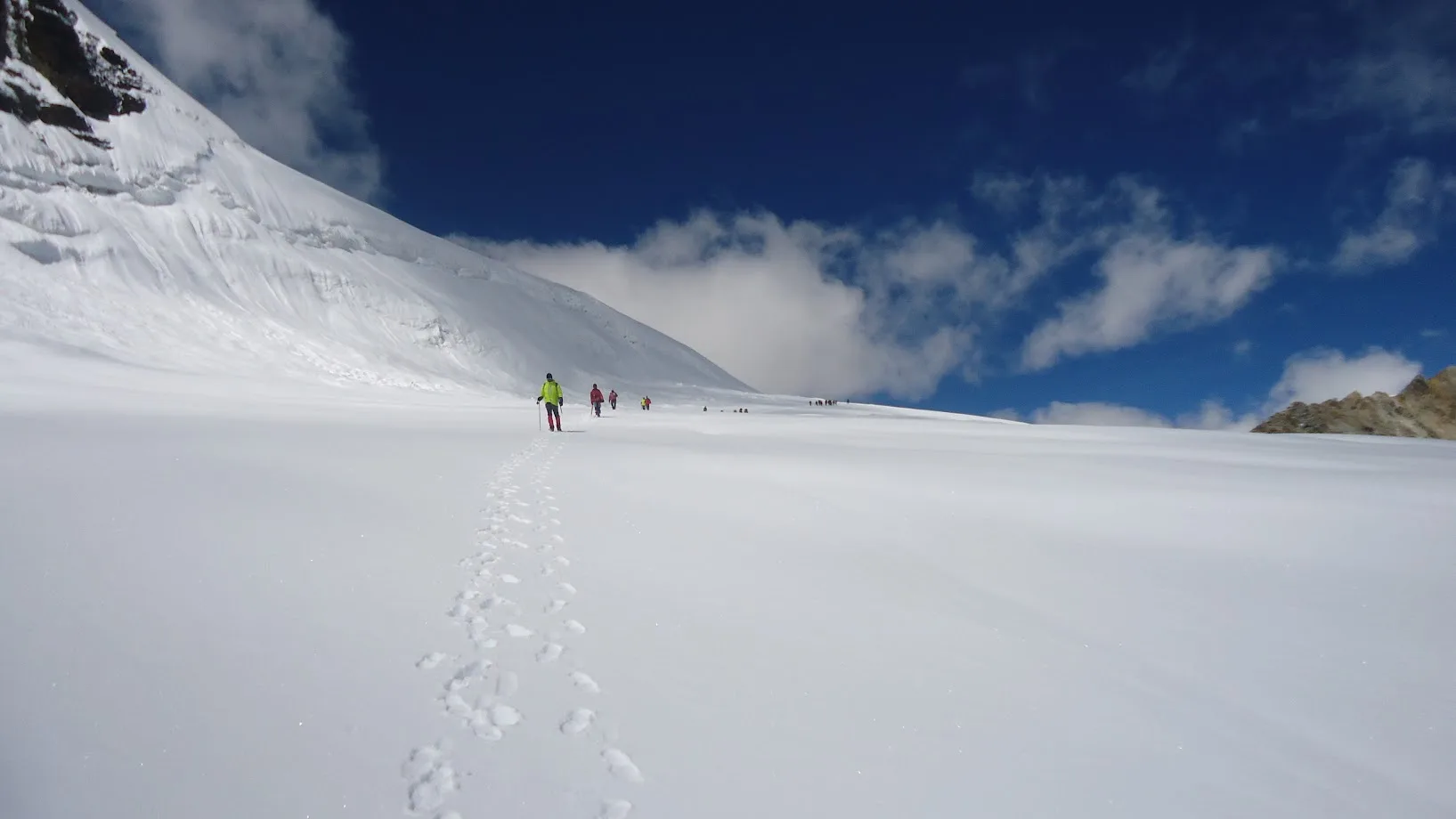
Kalindi Khal is widely regarded as the most difficult, highest, and most grueling trekking expedition in the Indian Himalayas. Peaking at an astonishing 19,521 ft (5,950m)—higher than the highest points of Europe, Africa, and Antarctica—it is a colossal glaciated pass that bridges the holy shrines of Gangotri and Badrinath. The route navigates across the absolute heart of the Garhwal Himalayas, walking directly over the treacherous Chaturangi and Sweta glaciers for days on end. Trekkers are dwarfed by an amphitheater of 23,000 ft peaks including Shivling, Meru, Bhagirathi massifs, and Kamet. It requires the physical conditioning of an ultra-marathoner and the technical skills of an alpinist. Roped-up glacier travel, crampon proficiency, and the ability to survive in sub -25°C environments are mandatory. This is not for trekkers; this is a true mountaineering proving ground.
Ready to book? Compare verified operators for Kalindi Khal Expedition — transparent pricing, no paid rankings.
Quick Facts
Duration
Max Altitude
Difficulty
Best Time
Trek Distance
Trail Atmosphere
Stargazing
Class 1 Dark Sky
Scent Profile
Silence Level
~5 dB
Vertigo Factor
5 / 10
Primarily a cumulative fatigue and altitude exposure challenge
An elite-level undertaking with extreme cumulative fatigue, altitude exposure, and joint & muscle impact. This route will push every dimension of your physical and mental endurance to the limit.
Iconic Spots
Kalindi Khal Sunrise
Getting There
Route to Base
10 hour drive from Dehradun
Base Village
Gangotri
10,000 ft
Nearest Railhead
Dehradun / Rishikesh
Nearest Airport
Jollygrant Airport (Dehradun)
Last ATM
Uttarkashi
Nearest Medical Facility
Uttarkashi / Joshimath
Mobile Signal
Zero.
Water Sources
Melted glacial snow. Boiling mandatory.
Charging
Zero.
For Drivers
Road Condition
National highway 34 up to Gangotri.
Uttarkashi
Trail Culinary & Diet
Don't miss the N/A
Buy specialized diet items at Dehradun
The Content & Remote Hub
No DronesStrictly banned near Indo-China border sector.Top Vlog Spots
Video Calls
none
Est. 0 Mbps
UPI Reliability
1/10
Guide Wisdom
Caution
A clear, sunny day on the glacier is a double-edged sword. It looks beautiful, but it melts the snow bridges over the crevasses, making the afternoon descent off the pass highly dangerous.
Explore In Detail
Day by Day Itinerary
15-day route reaching 19,521ft. Covers 99km of varied terrain.
→ See full itinerary with altitude profileDifficulty & Fitness
Rated extreme. Almost the entire expedition from Day 3 to Day 10 is on highly technical, shifting ice, crevassed glaciers, and treacherous moraine. No solid trail exists.
→ See difficulty breakdown and fitness guideCost & Pricing
Packages range from ₹80,000 to ₹1,20,000. Inclusions and hidden costs vary by operator tier.
→ See full cost breakdownPermits and Regulations
Heavily regulated by the Indian Mountaineering Foundation (IMF) and the DFO Uttarkashi. Due to its proximity to the Indo-China border, strictly vetted Inner Line Permits (ILP) are required. Foreign nationals face intense scrutiny and must apply months in advance.
Learn more about how we vet operators and ensure transparency on our why MountRoutes page.
Packing List
High-Alpine Technical Logistics
- Rigid mountaineering boots (B3/B2 rating mandatory)
- 12-point crampons (Fitted to boots beforehand)
- Climbing Harness, 2 Locking Carabiners, Ascender (Jumar), and Descender (Figure 8/ATC)
- Straight-shaft Ice Axe with leash
- Climbing Helmet
Extreme Cold & Glacial Exposure
- Heavy Expedition Down Jacket (Rating: -30°C comfort)
- Category 4 Glacier Glasses (Wrap-around to prevent side-glare blindness)
- Heavy Gore-Tex Hardshell pants (Ski-pants will tear on crampon points)
Survival & Sustainment
- -20°C Sleeping bag (Down insulation highly preferred)
- Double-insulated water flask (Water bladders will freeze and crack)
- High-calorie energy gels (Chewing solid food above 18k ft is exhausting)
Flora & Fauna
Flora
Fauna
The route is the cosmic connection between the sister rivers—Baghirathi (Ganges) and Alaknanda. It is considered a path so holy that dying on it guarantees moksha.
— Local folklore
Spiritual & Cultural Significance
A deeply physical manifestation of crossing the threshold between two of the holiest dhams.
🕐 Shrine Timings: N/A
Temple Protocols
Frequently Asked Questions
Is Kalindi Khal the toughest trek in India?
Yes. It holds the unofficial title due to its staggering 19,500 ft altitude, the number of days spent entirely on glacial ice, and the objective dangers of crevasses and avalanches.
Do I need prior mountaineering experience?
Absolutely. At minimum, you must have completed a Basic Mountaineering Course (BMC) or have successfully climbed multiple 6000m peaks. Basic trekkers will be turned back at Bhojbasa.
What is the peak altitude?
The pass itself sits at 5,950 meters (19,521 ft). This is significantly higher than Mount Elbrus or Kilimanjaro. You will feel extreme oxygen deprivation.
How cold does it get?
Night temperatures at Kalindi Base Camp (18,000 ft) routinely plunge to -20°C or -25°C, even in the peak trekking season of June or September.
Is there a real trail?
Only until Gomukh. After Gomukh, you are walking entirely on the shifting, chaotic ice and moraine of the Chaturangi, Sweta, and Kalindi Glaciers. The landscape changes weekly.
What happens if I get AMS?
Above Nandanvan (14,000 ft), evacuation is extremely difficult. If you display HAPE or HACE symptoms, your guide will administer Dexamethasone/Diamox and you must immediately descend. Helicopter rescue is highly unreliable due to winds.
Do we use ropes?
Yes. You will be roped to your team members while crossing the heavily crevassed glaciers to ensure that if someone falls through a snow bridge, the team can auto-arrest.
Where does the expedition start and end?
It starts at the Gangotri temple in the west, crosses the central spine of the Garhwal, and ends at the Badrinath temple in the east.
What is the descent like?
The descent off Kalindi Khal is notoriously steep, littered with hidden crevasses, and heavily avalanche-prone. It is often considered more dangerous than the ascent.
How long is the crossing?
From Gangotri to Badrinath, it usually takes 12 to 14 days of sustained walking, including mandatory acclimatization rest days.
Other Expeditions Guides
Still deciding?
Compare routes side-by-side to find the perfect match for your fitness, dates, and budget.
Everything you need to know, in one place. Someone else in your group needs to see this.
Planning Kalindi Khal Expedition?
Get route conditions, operator updates, and season windows before booking.
No spam. Only useful updates.
Ready to walk this route?
You’ve read the guide, now find the perfect local team to take you there. Compare our verified list of operators.
Compare verified operators