Essential Planning Guide
Hanuman Tibba Expedition — Complete Guide (2026)
Introduction
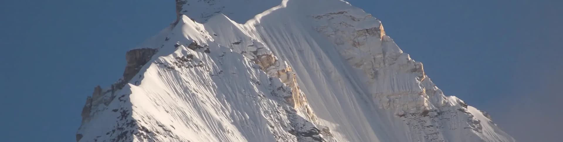
Rising to 5,982 m (19,625 ft), Hanuman Tibba dominates the skyline northwest of Manali as the highest summit of the Pir Panjal range. First climbed in 1912, the mountain remains one of the Western Himalayas' most respected technical objectives, combining a rich climbing history with demanding alpine terrain. The expedition approaches through the Beas Kund basin before entering heavily glaciated landscapes beneath the mountain. Climbers negotiate crevassed glaciers, steep snow and ice slopes, and the technically demanding Tentu Pass before the final summit ascent. Reserved for experienced mountaineers, Hanuman Tibba requires proficiency in glacier travel, rope techniques, crampon use, and expedition-style alpine climbing.
Ready to book? Compare verified operators for Hanuman Tibba Expedition — transparent pricing, no paid rankings.
Quick Facts
Duration
Max Altitude
Difficulty
Best Time
Trek Distance
Trail Atmosphere
Stargazing
Class 1 Dark Sky
Scent Profile
Silence Level
~10 dB
Vertigo Factor
8 / 10
Primarily a cardio demand and joint & muscle impact challenge
An elite-level undertaking with extreme cardio demand, joint & muscle impact, and cumulative fatigue. This route will push every dimension of your physical and mental endurance to the limit.
Iconic Spots
Yunam Summit (20,046 ft)
Getting There
Route to Base
Drive from Manali (~20km) to Dhundi in Solang Valley
Trek 2 days to Beas Kund Base Camp
Base Village
Dhundi (Solang Valley)
9,840 ft
Nearest Railhead
Chandigarh Railway Station (IXC)
Nearest Airport
Kullu-Manali Airport, Bhuntar (KUU) / Chandigarh (IXC)
Last ATM
Manali
Nearest Medical Facility
Lady Willingdon Hospital, Manali (~25km from Beas Kund)
Mobile Signal
None.
Water Sources
Snow melting required at Base Camp.
Charging
Zero charging points after Keylong.
For Drivers
Road Condition
Manali to Darcha is excellent highway. Darcha to Bharatpur is steep, unpaved highway traversing sheer cliffs.
Keylong / Jispa
Trail Culinary & Diet
Don't miss the High altitude noodle soups for fast carb absorption
Buy specialized diet items at Manali
The Content & Remote Hub
No DronesStrictly banned due to extreme high altitude and proxy to military checkposts.Top Vlog Spots
Video Calls
none
Est. 0 Mbps
UPI Reliability
1/10
Guide Wisdom
Caution
Tentu La is where this expedition wins or loses. Practice clipping and unclipping your ascender from the fixed rope in camp until it is fully automatic. On the actual pass at 3 AM in -15°C, you will not have the mental bandwidth for mistakes.
Explore In Detail
Day by Day Itinerary
10-day route reaching 19,626ft. Covers 45km of varied terrain.
→ See full itinerary with altitude profileDifficulty & Fitness
Rated extreme. One of the most serious peaks in Himachal Pradesh. Involves traversing the extremely dangerous Tentu Col across heavily crevassed glacier.
→ See difficulty breakdown and fitness guideCost & Pricing
Packages range from ₹40,000 – ₹65,000. Inclusions and hidden costs vary by operator tier.
→ See full cost breakdownPermits and Regulations
IMF (Indian Mountaineering Foundation) peak booking fees apply because the altitude crosses 6000 meters. A heavily monitored police checkpoint at Darcha records all climber passport/Aadhar details.
Learn more about how we vet operators and ensure transparency on our why MountRoutes page.
Packing List
Expedition Clothing
- Summit Down Jacket (-25°C rating mandatory)
- Waterproof breathable alpine trousers
- Heavyweight thermal baselayers (Upper & Lower)
- Fleece mid-layers
- Balaclava/Face mask (To prevent frostbite from summit winds)
Footwear & Navigation
- Category C or D Expedition Boots (Must be extremely stiff-soled)
- Gaiters (For walking through the deep snow on the upper ridges)
- Micro-spikes (Operator usually provides crampons if ice is hard)
Wilderness Survival Gear
- Category 4 Glacier glasses (Mandatory)
- Trekking poles with snow baskets
- Heavy-duty expedition mitts (Not just gloves)
Flora & Fauna
Flora
Fauna
Hanuman Tibba is believed by locals to be named after the monkey-god Hanuman. Shepherds from the Solang Valley consider the Beas Kund area sacred ground.
— Local folklore
Spiritual & Cultural Significance
Low. Purely a mountaineering challenge.
🕐 Shrine Timings: N/A
Temple Protocols
Frequently Asked Questions
Why is Hanuman Tibba rated Grade D while being below 6,000m?
Grade D reflects the technical difficulty of the Tentu La crossing — a 75–80° steep snow and ice slope that requires fixed ropes, vertical ascending, and confident crampon technique — not just the altitude. This is harder on a technical level than many 6,000m peaks like UT Kangri or Yunam.
Can I attempt Hanuman Tibba without prior mountaineering training?
No. The Grade D Tentu La crossing is genuinely dangerous for untrained climbers. Completing a Basic Mountaineering Course (BMC) from an IMF institute is the minimum prerequisite. An Advanced Mountaineering Course (AMC) is strongly recommended.
What is the best month/season to climb Hanuman Tibba?
The best season is pre-monsoon (June) and post-monsoon (September to early October). June is excellent as there is substantial snow cover on Tentu La, which makes climbing the couloir easier than when it turns to hard, exposed blue ice in late autumn.
How technical is the final summit ridge?
The final summit ridge is highly exposed and glaciated. It features a technical traverse of the mountain's upper plateau, followed by a steep snow climb to the pointed summit peak. Roped travel and snow-stakes/ice-screws are absolutely mandatory for protection.
What is the role of Tentu La in the expedition?
Tentu La (approx 4,990m) is the gateway to the upper plateau of Hanuman Tibba. It is the crux of the route — a steep, narrow couloir prone to rockfall and avalanches. Climbing Tentu La takes 6-8 hours of sustained front-pointing and roped ascension.
Where are the camp locations established above Base Camp?
Typically, Camp 1 is established just below the Tentu La pass (approx 4,800m), followed by a High Camp on the upper glacier plateau (approx 5,200m) from where the final summit push is launched.
Who made the first ascent of Hanuman Tibba?
General C.G. Bruce, Swiss mountain guide Heinrich Fuhrer, and Gurkha soldier Lal Bahadur made the first recorded ascent in 1912. Climbing activity was revived in the 1960s with a joint Indo-British expedition in 1966.
What kind of climbing gear is mandatory?
Climbers must have double mountaineering boots (plastic or specialized high-altitude boots), climbing harness, crampons, ice axes (technical or semi-technical), ascending devices (Jumars), helmets, carabiners, and descenders.
How cold does it get at the upper high camps?
At the upper glaciated plateau (High Camp), night temperatures routinely drop below -15°C to -20°C. Winds are severe on the open plateau, making high-quality windproof 4-season tents and expedition-grade down gear essential.
What are the primary objective hazards on Hanuman Tibba?
Rockfall and ice-avalanche risk inside the Tentu La couloir are the primary hazards. Hidden crevasses on the upper plateau also present a serious threat, meaning rope team discipline must be strictly maintained at all times.
Is helicopter evacuation feasible on Hanuman Tibba?
Evacuation from the upper glaciated plateau is extremely difficult due to high winds and lack of flat landing zones. While helicopter pick-up is technically possible, a ground-rescue team hauling the casualty down to Beas Kund BC is often the primary evacuation method.
How is water obtained at the high camps?
At Beas Kund BC, fresh stream water is abundant. At Camp 1 and High Camp, climbers must melt snow using high-efficiency multi-fuel or butane/propane stoves (MSR or Jetboil). Keeping fuel canister warm is essential for optimal stove performance.
Other Expeditions Guides
Still deciding?
Compare routes side-by-side to find the perfect match for your fitness, dates, and budget.
Everything you need to know, in one place. Someone else in your group needs to see this.
Planning Hanuman Tibba Expedition?
Get route conditions, operator updates, and season windows before booking.
No spam. Only useful updates.
Ready to walk this route?
You’ve read the guide, now find the perfect local team to take you there. Compare our verified list of operators.
Compare verified operators