Essential Planning Guide
Dzo Jongo East Peak Expedition — Complete Guide (2026)
Introduction
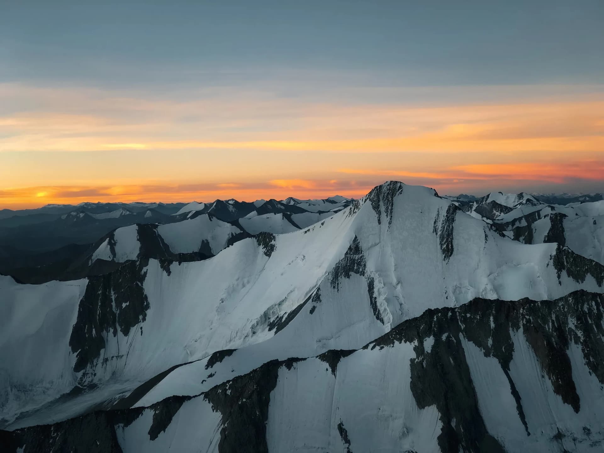
Rising to 6,189 m (20,305 ft), Dzo Jongo East stands quietly above the upper Markha Valley as one of Ladakh's finest yet lesser-known expedition peaks. Its relatively straightforward route, combined with outstanding panoramic views, makes it an outstanding objective for trekkers progressing toward Himalayan mountaineering. The expedition follows the scenic valleys of Hemis National Park before climbing onto increasingly barren alpine terrain where broad scree slopes transition into permanent snowfields. The final ascent follows the East Ridge across snow and loose rock before reaching a spectacular summit overlooking Kang Yatse, the Zanskar Range, Stok Kangri, and the distant Karakoram. Offering genuine expedition experience without extreme technical climbing, Dzo Jongo East is an ideal first or second 6,000-meter objective.
Ready to book? Compare verified operators for Dzo Jongo East Peak Expedition — transparent pricing, no paid rankings.
Quick Facts
Duration
Max Altitude
Difficulty
Best Time
Trek Distance
Trail Atmosphere
Stargazing
Class 1 Dark Sky
Scent Profile
Silence Level
~20 dB
Vertigo Factor
4 / 10
Primarily a cumulative fatigue and joint & muscle impact challenge
A demanding expedition with extreme cumulative fatigue, joint & muscle impact, and altitude exposure. This route will push every dimension of your physical and mental endurance to the limit.
Iconic Spots
Getting There
Route to Base
Fly to Leh
Drive to Chilling to start trek
Base Village
Leh
11,500 ft
Nearest Railhead
Jammu Tawi (JAT)
Nearest Airport
Kushok Bakula Rimpochee Airport, Leh (IXL)
Last ATM
Leh
Nearest Medical Facility
Leh SNM Hospital
Mobile Signal
None on trek
Water Sources
Rivers and streams
Charging
Solar chargers at camps
For Drivers
Road Condition
Leh to Chilling is mostly paved but prone to seasonal landslides.
Leh
Trail Culinary & Diet
Don't miss the Thukpa
Buy specialized diet items at Leh
The Content & Remote Hub
UPI Reliability
0/10
Guide Protocol
Key point
Explore In Detail
Day by Day Itinerary
12-day route reaching 20,299ft. Covers 85km of varied terrain.
→ See full itinerary with altitude profileDifficulty & Fitness
Rated challenging. Long scree approach and glacier walking on the East Ridge.
→ See difficulty breakdown and fitness guideCost & Pricing
Packages range from ₹51,000 – ₹76,000. Inclusions and hidden costs vary by operator tier.
→ See full cost breakdownPermits and Regulations
Both IMF and wildlife department permits must be carried at all times.
Learn more about how we vet operators and ensure transparency on our why MountRoutes page.
Packing List
Clothing
- Glacier Glasses (Cat 4)
- Balaclava
- Neck gaiter
- Woolen cap
Gear & Equipment
- Headlamp with spare batteries
- Water bottles (insulated thermal flasks)
- Pocket knife / Multitool
- Personal medical kit
Flora & Fauna
Flora
Fauna
Markha Valley protector spirits.
— Local folklore
Spiritual & Cultural Significance
Temple Protocols
Frequently Asked Questions
Is Dzo Jongo East Peak technical?
Dzo Jongo East Peak is classified as a semi-technical trekking peak (climbing grade PD/PD+ depending on snow conditions). Unlike Dzo Jongo West, which is a straightforward non-technical walk-up, Dzo Jongo East features a steep summit ridge (35° to 45° snow/ice) that requires fixed ropes, harness systems, crampons, and ice axes.
How is it different from Dzo Jongo West?
Dzo Jongo West (6,280m) is higher but technically easier, requiring mostly basic snow walking and trekking poles. Dzo Jongo East (6,189m), although slightly lower, is far more technical due to its exposed summit ridge and rock-fall risk, demanding proper mountaineering equipment (harness, crampons, rope teams).
What is the best month to climb Dzo Jongo East?
The optimal window is from July to September. During this period, the Markha Valley is dry due to the Trans-Himalayan rain shadow. July has more snow on the ridge which can make cramponing easier, while August and September have harder ice and less snow, exposing scree sections.
Do I need prior mountaineering experience to climb Dzo Jongo East?
You do not need formal mountaineering courses, but you must have experience with multi-day high-altitude treks above 15,000 ft (e.g., Stok Kangri, Pin Parvati, or Roopkund). A robust cardiovascular fitness level is mandatory as the summit push is extremely grueling.
Where do we get drinking water on the trek?
Water is collected from natural glacial meltwater streams near the campsites. Outfitters boil this water or treat it with chlorine tablets. It is highly recommended to carry water purification tablets or a portable filter (like Lifestraw) for personal use.
Is Diamox recommended for Dzo Jongo East?
Yes, prophylactic Diamox is commonly used. Because you fly directly into Leh at 11,500 ft, a strict 2-3 day acclimatization schedule is followed. Diamox helps accelerate red blood cell production, but must be taken after consulting your medical professional.
How cold does it get at the High Camp / Base Camp?
Base Camp temperatures can plunge to -5°C to -10°C at night, especially in September. On the summit day, wind chill factor on the ridge can cause temperatures to feel as low as -15°C. A high-quality -20°C rated sleeping bag and a 4-layer down suit are mandatory.
Are there mobile networks or charging facilities available?
There is zero mobile coverage once you cross Skiu. The last reliable network is BSNL/Airtel in Leh and partially at Chilling. There are no charging points on the trek; you must carry high-capacity power banks (at least 20,000 to 30,000 mAh) kept inside your sleeping bag to prevent battery drainage in cold weather.
What is the summit day duration and start time?
The summit day starts with an alpine wake-up around 11:30 PM. Climbers begin the push by 1:00 AM to navigate the frozen snow slopes before the sun warms the snow, making it soft and hazardous. The round trip from Base Camp to the summit and back takes 10 to 12 hours.
What permits are required for Dzo Jongo East, and who handles them?
A climbing permit from the Indian Mountaineering Foundation (IMF) or the local Ladakh Autonomous Hill Development Council (LAHDC) is required. Registered operators generally handle these permits as part of their package, but you must provide personal identification (Aadhar/Passport) and a certified medical fitness certificate.
Is there helicopter rescue available on the route?
Helicopter rescue is feasible in the Markha Valley but is highly dependent on weather conditions and clearance from the Indian Air Force. Having comprehensive rescue-inclusive adventure travel insurance is mandatory before commencing the climb.
How is load ferry managed for the expedition?
Horses and porters manage the main camp luggage and kitchen equipment up to the Base Camp. However, climbers are expected to carry their own personal daypack (5-7 kg) containing hydration, spare layers, and immediate medical supplies.
Other Expeditions Guides
Still deciding?
Compare routes side-by-side to find the perfect match for your fitness, dates, and budget.
Everything you need to know, in one place. Someone else in your group needs to see this.
Planning Dzo Jongo East Peak Expedition?
Get route conditions, operator updates, and season windows before booking.
No spam. Only useful updates.
Ready to walk this route?
You’ve read the guide, now find the perfect local team to take you there. Compare our verified list of operators.
Compare verified operators