Essential Planning Guide
Rudranath Trek — Complete Guide (2026)
Introduction
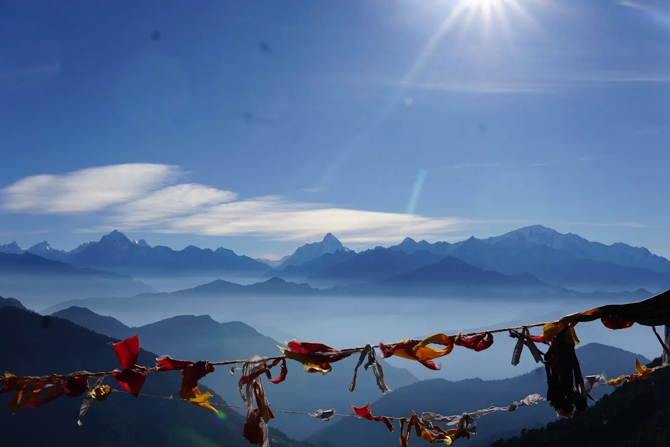
Rudranath is the 'Hardest' and most profoundly spiritual of the Panch Kedar shrines. Located at 11,800 ft in the Chamoli district, it is the only temple where the face of Lord Shiva is worshipped in his 'Nilkanth' form, with eyes closed in eternal meditation. The trek is a legendary test of physical and mental endurance, famously requiring a 6,000 ft vertical ascent in a single day from the base village of Sagar. But the struggle is rewarded with what many consider the most cinematic views in the Himalayas. From the high-altitude meadows of Panar Bugyal, the massifs of Nanda Devi, Trishul, and Chaukhamba feel close enough to touch. Rudranath is not a trek for the casual hiker; it is a pilgrimage of grit, silence, and unparalleled alpine beauty.
Ready to book? Compare verified operators for Rudranath Trek — transparent pricing, no paid rankings.
Quick Facts
Duration
Max Altitude
Difficulty
Best Time
Trek Distance
Trail Atmosphere
Stargazing
Class 1 Dark Sky
Scent Profile
Silence Level
~30 dB
Vertigo Factor
2 / 10
Primarily a cardio demand and joint & muscle impact challenge
A capable trekker's route with extreme cardio demand and joint & muscle impact.
Iconic Spots
Panar Bugyal Viewpoint
The Face Shrine
Getting There
Route to Base
10-hour drive from Rishikesh
Taxis available at Rishikesh Natraj Chowk (6 AM)
Base Village
Sagar Village (Gopeshwar)
5,000 ft
Nearest Railhead
Rishikesh
Nearest Airport
Jollygrant Airport
Last ATM
Gopeshwar (5km away). Absolutely zero ATMs beyond Sagar.
Nearest Medical Facility
Gopeshwar District Hospital
Mobile Signal
Strong 4G at Sagar/Gopeshwar. Spotty Jio at Panar (viewpoint only). Zero connectivity at the main Rudranath shrine.
Water Sources
Abundant from sacred springs and the Vaitarani river tributaries. Reliable natural wells at Sagar, Panar, and the Rudranath temple precinct.
Charging
Available at Sagar (Base) village. Extremely limited solar capacity at Panar Bugyal homestays (Paid/Limited). None at the temple cave.
For Drivers
Road Condition
Road from Gopeshwar to Sagar is excellent; standard hill driving parameters.
Gopeshwar
Trail Culinary & Diet
Don't miss the Garhwali Mandua ki Roti
Buy specialized diet items at Gopeshwar / Chamoli
The Content & Remote Hub
Top Vlog Spots
Video Calls
base-only
Est. 20 Mbps
UPI Reliability
5/10
Base WiFi Available
The Faces of Shiva
Key point
Rudranath is where the face of Shiva is worshipped. The closed eyes signify his 'Nilkanth' state of deep meditation.
Key point
The temple is managed by the local priests of Gopeshwar. It is raw, intimate, and deeply silent.
Explore In Detail
Day by Day Itinerary
5-day route reaching 12,500ft. Covers 36km of varied terrain.
→ See full itinerary with altitude profileDifficulty & Fitness
Rated moderate. Consistent steep ascent on stone-paved forest trails. High impact rocky terrain at the ridge. Final descent on stone steps is physically punishing.
→ See difficulty breakdown and fitness guideCost & Pricing
Packages range from ₹11,500 – ₹19,500. Inclusions and hidden costs vary by operator tier.
→ See full cost breakdownPermits and Regulations
The trek falls within the Kedarnath Wildlife Sanctuary. Entry permits are issued at the forest check post in Sagar Village. Indian nationals require a photo ID and a medical fitness certificate (obtainable in Gopeshwar). Foreigners must provide passport/visa copies. Camping is restricted to designated areas like Panar and Lunti to protect the fragile alpine ecosystem. Mules are extremely rare on this route due to the steep stone steps; porters are the primary mode of logistics.
Learn more about how we vet operators and ensure transparency on our why MountRoutes page.
Packing List
Winter Clothing
- Light down jacket
- 2 thermal t-shirts
- 1 fleece mid-layer
- Windproof jacket
- Trekking pants
- Woolen socks (2 pairs)
- Sun hat and sunglasses
Footwear Snow Gear
- High-ankle boots with solid grip (essential for steps)
- Camp slippers
Gear Safety
- 2 Trekking poles (Mandatory for the 6,000ft descent)
- Headlamp with spare batteries
- Knee supports/Caps (Highly recommended)
- Water bottle (3L capacity minimum for Day 2)
- Personal medical kit (Salt for leeches)
Flora & Fauna
Flora
Fauna
The 'Face' (Mukha) of Shiva. The only Panch Kedar where Shiva is worshipped as Neelkanth (The face with the blue throat). Part of the sacred Panda burial and veneration route of the local Garhwali tribes.
— Local folklore
Spiritual & Cultural Significance
One of the five most sacred Shiva temples; part of the Panch Kedar soul route.
🕐 Shrine Timings: 06:00 AM - 08:00 PM
Temple Protocols
- •Traditional Garhwali reverence expected
- •No photography inside the main cave sanctum
Festivals & Dates
Frequently Asked Questions
Why is Rudranath unique among Panch Kedars?
It is the only temple where the face (mukh) of Lord Shiva is worshipped as "Nilkanth Mahadev".
How steep is the climb from Sagar village?
It is a relentless vertical climb of nearly 1,200 meters. It is considered one of the steepest single-day ascents in the region.
What is the Vaitarani River?
Known as the "River of Salvation", pilgrims cross this stream near the temple to perform rituals.
Can we see Nanda Devi from the temple?
Yes, the temple complex offers a direct, majestic view of MT. Trishul, Nanda Devi, and Nanda Ghunti.
Is the trek open in winter?
No, the temple closes in November and reopens in May. The route becomes inaccessible due to heavy snow in the higher bugyals.
Where can we stay near the temple?
There are basic dharamshalas and local huts that provide sleeping bags and simple meals.
Are there leeches on the Sagar route?
Yes, especially in the oak forest section during the monsoon and early September. Carry salt or tobacco.
What is the total trekking distance?
Approximately 20km one way from Sagar village, usually covered in 2 days of trekking.
Other Treks Guides
Still deciding?
Compare routes side-by-side to find the perfect match for your fitness, dates, and budget.
Everything you need to know, in one place. Someone else in your group needs to see this.
Planning Rudranath Trek?
Get route conditions, operator updates, and season windows before booking.
No spam. Only useful updates.
Ready to walk this route?
You’ve read the guide, now find the perfect local team to take you there. Compare our verified list of operators.
Compare verified operators