Essential Planning Guide
Pindari Kafni Sunderdhunga Grand Circuit Trek — Complete Guide (2026)
Introduction
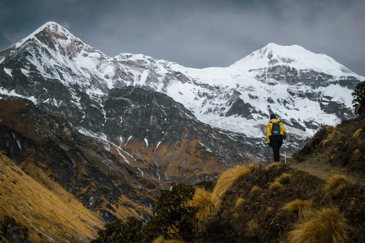
The Pindari-Kafni Crossover is the definitive inner Kumaon glacier circuit — a 9-day loop from Loharkhet that visits two of the most impressive glaciated valleys in the Kumaon Himalaya without repeating any significant section of trail, creating a complete traverse of the Pindar and Kafni river headwaters. The circuit crosses from the Pindari glacier system (classic, well-maintained, Forest Rest House route) to the Kafni glacier (wilder, steeper, higher at 13,900 ft) via an inter-valley ridge crossing — the Pindari-Kafni col, which most organized trekkers never attempt on the standard out-and-back Pindari route. Below: Pindari glacier at 12,300 ft (the famous Zero Point with Nanda Khat, Nanda Devi, and Changuch in view) and Kafni glacier at 13,900 ft (dominated by the pyramid Nanda Kot at 6,861m). The glaciers are fundamentally different in character: Pindari is wide, gradual, and accessible, with mature Forest Rest Houses at Phurkiya and Zero Point; Kafni is narrower, steeper, more physically demanding, and culminates in a far wilder moraine bowl below Nanda Kot's sheer south face. The crossover between the two valleys — via the high shoulder above Phurkiya — is the only section with genuine navigation challenge and is what makes this a circuit rather than an out-and-back.
Ready to book? Compare verified operators for Pindari Kafni Sunderdhunga Grand Circuit Trek — transparent pricing, no paid rankings.
Quick Facts
Duration
Max Altitude
Difficulty
Best Time
Trek Distance
Trail Atmosphere
Stargazing
Class 1 Dark Sky
Scent Profile
Silence Level
~5 dB
Vertigo Factor
2 / 10
Primarily a joint & muscle impact and cumulative fatigue challenge
A capable trekker's route with extreme joint & muscle impact and cumulative fatigue.
Iconic Spots
Pindari-Kafni Col (13,200 ft) — Two Glacier Systems Visible
Kafni Base Camp — Nanda Kot South Face
Pindari Zero Point — Full Glacier Panorama
Getting There
Route to Base
Kathgodam → Almora → Bageshwar → Kapkote → Song/Loharkhet (175 km, 7 hrs)
Private taxi from Kathgodam standard
Nearest rail: Kathgodam (175 km)
Nearest airport: Pantnagar (160 km)
Base Village
Loharkhet / Song (Road End, ~6,700 ft), then Khati Village (7,117 ft) as circuit hub
6,700 ft
Last ATM
Bageshwar town (50 km from Song). Carry ALL cash from Bageshwar — 9-day circuit with zero ATM access.
Nearest Medical Facility
Bageshwar District Hospital (50 km, 3 hrs from Song). PHC at Kapkote (intermediate).
Mobile Signal
Song/Loharkhet: limited. Zero from Day 2 Khati onward through full Kafni wilderness.
Water Sources
Pindar river and tributaries (Days 1-4). Kafni gad (Days 5-7). Col crossing: carry 2L from Phurkiya. Abundant throughout except on col crossing day.
Charging
FRH at Dhakuri, Dwali, Phurkiya (generator power — limited hours). Zero on Kafni side. Bring 30,000 mAh power bank.
For Drivers
Road Condition
Kathgodam to Bageshwar (120 km, 4 hrs). Bageshwar to Song (50 km, 2.5 hrs) — narrow unpaved last 15 km. Landslide risk July–August.
Bageshwar (50 km from Song)
Trail Culinary & Diet
Don't miss the Khati bhatt ki churkani (Kumaoni black soybean curry with rice) — serve yourself generously at the Day 7 Khati homestay dinner. After 6 wilderness days, this meal is the finest restaurant experience available within 50 km.
Buy specialized diet items at Bageshwar town. FRH kitchens provide basic vegetarian meals — dal, rice, sabzi. Carry specialized nutrition from Bageshwar. Khati homestay: excellent traditional Kumaoni food.
The Content & Remote Hub
Top Vlog Spots
Video Calls
none
Est. 0 Mbps
UPI Reliability
2/10
The Right Col
Key point
Above Phurkiya FRH, the terrain opens into a complex of grass slopes, moraine fingers, and false ridgelines presenting at least 4 apparent col options visible from below. Only one is the correct Kafni drainage col at 13,200 ft. The others lead either to precarious terrain or into dead-end moraine. Your guide's body memory of this specific crossing — not GPS, not topo map — is what makes the crossover feasible. Verify your guide's Kafni col experience explicitly before hiring.
Explore In Detail
Day by Day Itinerary
9-day route reaching 13,900ft. Covers 100km of varied terrain.
→ See full itinerary with altitude profileDifficulty & Fitness
Rated moderate. Multi-type: maintained forest trail (Days 1-2, 8-9), canyon valley trail (Days 2-3), glacial moraine (Days 4, 6), unmarked inter-valley col (Day 5), wilderness camp descent (Day 7). Day 5 (col crossing) is the most demanding and unique section requiring guide navigation.
→ See difficulty breakdown and fitness guideCost & Pricing
Packages range from ₹16,000 to ₹30,000. Inclusions and hidden costs vary by operator tier.
→ See full cost breakdownPermits and Regulations
No formal trek permit required. Forest Department registration at Loharkhet checkpost. FRH booking for Dhakuri, Dwali, and Phurkiya is mandatory — book 2-3 months in advance through the Divisional Forest Officer, Bageshwar. No open fires in the FRH premises or in the wilderness sections. Carry all waste out.
Learn more about how we vet operators and ensure transparency on our why MountRoutes page.
Packing List
9-Day Kumaon Circuit
- All food carry for 9 days from Loharkhet — no resupply above Song (FRH kitchen available at Dwali, Phurkiya, Kafni — confirm menu options and bring supplements)
- 4-season tent for Kafni camp section — no FRH at Kafni base, full wilderness camping
- Down sleeping bag -15C rated — Kafni camp (13,900 ft) has very cold nights in October
Pindari-Kafni Col Navigation
- Microspikes or traction device for the inter-valley col crossing (possible firm snow October, early morning)
- Trekking poles — essential throughout moraine sections on both glaciers
- GPS with offline topo for col navigation (guide handles this but backup useful)
Glacier Documentation
- Long telephoto for Nanda Kot south face detail from Kafni base
- Wide angle for full Pindari glacier panorama from Zero Point
- ND filter for glacier meltwater stream photography
Flora & Fauna
Flora
Fauna
The Pindari glacier is traditionally called 'Pinder' in old Kumaoni usage — a name linked to the mythological Pandavas of the Mahabharata who are said to have crossed the Pindari glacier on their final journey to the Himalayas. The Kafni glacier has a different association: local shepherd families from Khati call it 'Kafni devi ka bugyaal' — the meadow of the Kafni goddess — a name suggesting a pre-Hindu animist deity association with the glacier valley specific to the Khati shepherd lineage.
— Local folklore
Spiritual & Cultural Significance
Khati village has a traditional devta mandir associated with the glacier seasons. The Pindari glacier is mythologically linked to the Pandavas. The Kafni glacier name has local animist goddess associations in Khati village tradition.
🕐 Shrine Timings: Khati village mandir: informal timings. Ask homestay host for puja time.
Temple Protocols
Festivals & Dates
Frequently Asked Questions
What is the Pindari-Kafni col crossing like?
The col crossing from the Pindari valley to the Kafni valley (above Phurkiya) is a 3–4 hour navigation on unmarked terrain between two glacier drainage systems, reaching approximately 13,200 ft at the col. No technical climbing, but route-finding without a local guide is not feasible — the col is not signed and the terrain above Phurkiya is open moraine and grass slope.
How different are the two glaciers?
Fundamentally different in character. Pindari: gradual approach with Forest Rest Houses, wide glacier snout, accessible at 12,300 ft. Kafni: steeper approach with no FRH, narrower valley, higher base camp at 13,900 ft, dominated by the sheer south face of Nanda Kot. The crossover makes this a richly contrasted experience.
What peaks are visible from the two glacier viewpoints?
From Pindari Zero Point: Nanda Khat (6,611m), Nanda Devi (visible, 7,816m), Changuch (6,322m), Pindari Glacier snout. From Kafni base camp (13,900 ft): Nanda Kot south face (6,861m) — one of the finest single-peak south face views in Kumaon. Different peaks, different visual atmospheres.
Can the crossover be done in the reverse direction?
Yes — Kafni first, crossover, Pindari second. Either direction works. The standard forward direction (Pindari first via FRH, then crossover to Kafni) is slightly easier logistically as the FRH accommodation on the Pindari side is more comfortable for the first days when the group is fresh.
Are Forest Rest Houses available on the full route?
On the Pindari side: Forest Rest Houses at Dhakuri (9,200 ft, must book months ahead), Dwali (9,780 ft), and Phurkiya (12,000 ft). The Kafni side has no FRH — completely wilderness camping from the crossover col to Kafni base and back to Khati. Plan food and camping accordingly.
What permits are needed?
No formal trek permit for either Pindari or Kafni. Standard Forest Department registration at Loharkhet checkpost. The FRH bookings are through the Forest Department Kumaon Division — essential for the Pindari-side accommodation.
Is technical gear needed?
Microspikes recommended for the col crossing in October (morning frost on slope). No full crampons, no ice axe needed for either glacier snout. The Kafni moraine is demanding but non-technical.
How many people do this crossover version?
The standard Pindari out-and-back: 3,000+ per year. The Kafni out-and-back adds perhaps 500 per year. The Pindari-Kafni crossover circuit: estimated 100-200 per year — the col navigation requirement filters out most organized commercial groups.
What accommodation is at Khati village?
Excellent — Khati is the established hub for all three Pindari/Kafni/Sundardhunga glaciers. Multiple homestays with good traditional Kumaoni food, clean rooms, and reliable host families. The best base village in the Bageshwar trekking zone.
What is the best season?
May–June (pre-monsoon) or September–October (post-monsoon). October gives the maximum clarity at both glacier viewpoints — dry moraine, sharp Nanda Kot south face, and the best photography conditions. June gives snow-covered upper valley drama. Avoid July–August (monsoon).
What does the Grand Circuit Crossover involve?
The Grand Circuit is the ultimate Kumaon trek, connecting three legendary glacial valleys (Pindari, Kafni, and Sunderdhunga) over a demanding 9-day high-altitude trail.
What is the key difference between Pindari and Kafni glaciers?
Pindari glacier is a massive, wide valley glacier with a well-defined trail, while Kafni is narrower, wilder, less crowded, and offers a more intimate look at Mt. Nanda Kot.
How difficult is the Sunderdhunga section of the circuit?
Sunderdhunga ('Valley of Beautiful Stones') is highly technical, involving steep rocky ledges, active landslide zones, and near-vertical climbs to the high meadows of Maiktoli base.
Are there tea houses available along the entire circuit?
Basic tea houses are available on the Pindari trail. However, the Kafni and Sunderdhunga valleys are wilder and require fully self-sustained alpine camping.
What is the highest point reached on the Grand Circuit?
The trek peaks at Zero Point Pindari (12,300 ft) and Maiktoli Base Camp in Sunderdhunga (14,200 ft), offering close-ups of Maiktoli and Panwali Dwar peaks.
Other Treks Guides
Still deciding?
Compare routes side-by-side to find the perfect match for your fitness, dates, and budget.
Everything you need to know, in one place. Someone else in your group needs to see this.
Planning Pindari Kafni Sunderdhunga Grand Circuit Trek?
Get route conditions, operator updates, and season windows before booking.
No spam. Only useful updates.
Ready to walk this route?
You’ve read the guide, now find the perfect local team to take you there. Compare our verified list of operators.
Compare verified operators