Essential Planning Guide
Nandikund Trek — Complete Guide (2026)
Introduction
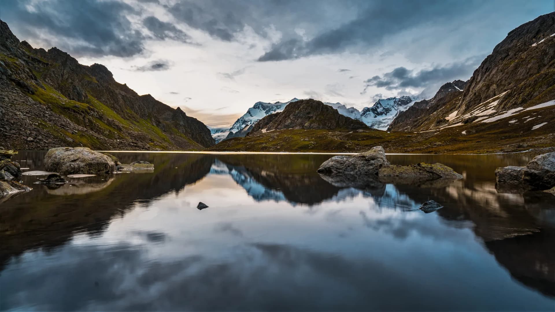
Nandikund is one of the Himalayas' most mythologically charged lakes — a high-altitude glacial lake at 14,268 ft where, according to local legend, Lord Shiva's sacred sword (khand) fell and sank into the depths. Tucked deep into the Ransi River valley above Ransi Village in Chamoli district, Nandikund sits beneath a dramatic cirque of unnamed peaks and glaciers. The trek is extraordinarily offbeat — it sees fewer than 200 trekkers per year — passing through pristine bugyals, ancient shepherd trails, and stunning high-altitude terrain that most trekkers in India never encounter. The lake itself is a vivid blue-green oval, mirror-smooth on clear days, ringed by snowfields that persist even in September. For those seeking a genuinely undiscovered Himalayan gem with mythological depth and complete solitude, Nandikund is the answer.
Ready to book? Compare verified operators for Nandikund Trek — transparent pricing, no paid rankings.
Quick Facts
Duration
Max Altitude
Difficulty
Best Time
Trek Distance
Trail Atmosphere
Stargazing
Class 1 Dark Sky
Scent Profile
Silence Level
~8 dB
Vertigo Factor
2 / 10
Primarily a joint & muscle impact and cardio demand challenge
A demanding expedition with extreme joint & muscle impact, cardio demand, and altitude exposure. This route will push every dimension of your physical and mental endurance to the limit.
Iconic Spots
Nandikund Sunrise Mirror
Getting There
Route to Base
Drive from Rishikesh to Ukhimath, and then a short drive to Ransi village
Base Village
Ransi / Madmaheshwar
5,400 ft
Last ATM
Gopeshwar
Nearest Medical Facility
Gopeshwar District Hospital
Mobile Signal
BSNL at Ransi. Zero signal above.
Water Sources
River up to Bamak. Springs near high camp. Lake water (treat before drinking).
Charging
None above Ransi.
For Drivers
Road Condition
Gopeshwar to Ransi is a narrow potholed road.
Gopeshwar
Trail Culinary & Diet
Don't miss the Jhangora ki kheer (local pearl millet dessert from Ransi)
Buy specialized diet items at Gopeshwar
The Content & Remote Hub
Top Vlog Spots
Video Calls
none
Est. 0 Mbps
UPI Reliability
1/10
Guide Wisdom
Caution
The local Ransi guides know the exact line across the snowfield to the lake. In fog, the snowfield can completely disorient you — the guide's footstep familiarity with this terrain is lifesaving.
Explore In Detail
Day by Day Itinerary
7-day route reaching 14,268ft. Covers 47km of varied terrain.
→ See full itinerary with altitude profileDifficulty & Fitness
Rated challenging. Mixed forest and boulder terrain. Upper section involves snowfield crossing. No technical climbing but requires strong fitness.
→ See difficulty breakdown and fitness guideCost & Pricing
Packages range from ₹14,000 to ₹20,000. Inclusions and hidden costs vary by operator tier.
→ See full cost breakdownPermits and Regulations
Forest entry permit from Chamoli Forest Checkpost in Ransi (₹100/person). Photography restrictions near the lake's religious area. Foreigners require Inner Line Permits from Chamoli SDM office.
Learn more about how we vet operators and ensure transparency on our why MountRoutes page.
Packing List
Essential Clothing
- Insulated down jacket rated to -10°C (lake campsite is brutally cold)
- Hardshell waterproof jacket
- Warm fleece and thermal base layer
- Convertible trekking pants
- Sun hat and balaclava
Footwear
- High-ankle waterproof trekking boots (mandatory)
- Microspikes or light crampons if attempting post-September
- Camp sandals
Camping Essential
- 3-season tent rated to -5°C or better
- Sleeping bag rated to -10°C
- Portable stove and fuel canisters (3-4 needed)
- 4 days of emergency dry rations
Flora & Fauna
Flora
Fauna
Lord Shiva's sacred weapon (khand/sword) fell into this lake during battle with demons. The lake is considered so sacred that even touching its water without prayer is believed to bring misfortune.
— Local folklore
Spiritual & Cultural Significance
The mythological site of Lord Shiva's sacred sword. Small shrine at lake edge tended by a local pujari during summer months.
🕐 Shrine Timings: No fixed timings. Pujari presence varies.
Temple Protocols
- •Ritual prayer before lake darshan is local custom
- •No loud noise near the lake
Festivals & Dates
Frequently Asked Questions
What makes Nandikund different from other Himalayan lakes?
Its mythological significance (Shiva's sword), near-zero foot traffic, extraordinary high-altitude setting at 14,268 ft, and the presence of permanent snowfields around the lake even in September make it uniquely raw compared to commercialized lakes like Chandratal or Rupin Pass.
Is there a connection between Nandikund and Rudranath?
Yes. Both are in the Ransi Valley. Experienced trekkers sometimes combine the two in a 10-12 day itinerary visiting both the Rudranath temple and the Nandikund lake. This requires an expert operator.
What is the base village?
Ransi Village, located 3 km from the main highway on a side road off the Gopeshwar-Ukhimath route. It's a traditional Garhwali hamlet with very basic homestay options.
Are there any camps or teahouses beyond Ransi?
None. This is a fully self-sufficient camping trek. All food, fuel, and equipment must come from Ransi or be arranged by the operator in advance.
What is the lake's legend?
Local Chamoli legend holds that when Lord Shiva was battling demons, his divine sword (nandi-khand) fell from the heavens and plunged into this lake. The sword is said to still rest at the lake's bottom, and the lake's waters are considered sacred.
Can I swim in the lake?
The water hovers near freezing temperatures even in summer. While locals may ritually enter the water during religious occasions, swimming is strongly discouraged for safety reasons.
What peaks are visible from Nandikund?
From the lake-side, the views include the massive Mandani Group of peaks, distant Nanda Devi East, Chaukhamba, and an unnamed 6,000m+ peak that forms the dramatic headwall above the lake's southern shore.
How strict is the guide requirement here?
Absolute. The trail from Ransi is completely unmarked after the first shepherd settlement. Fog is common above 11,000 ft. Multiple trekkers have been reported missing on the upper approach without a guide.
What is the best time for photography?
September mornings offer mirror-lake reflections with absolutely zero wind. The side-lighting at 6 AM paints the unnamed peaks above the lake in vivid orange — an extraordinary photography opportunity.
How does this compare to the more popular Satopanth Lake?
Satopanth is more accessible (drive starts from Mana), gets more traffic, and its mythology is better known. Nandikund is deeper wilderness, higher relative difficulty, and offers genuine archaeological solitude that Satopanth has now lost.
What is Nandikund and why is it sacred?
Nandikund is a high-altitude emerald green lake situated at 15,700 ft. Mythology says it is the place where Lord Shiva's holy bull (Nandi) drank water. A small temple dedicated to Nandi stands near the lake.
How difficult is the crossover via Gimi Pass on this trek?
Gimi Pass (16,000 ft) is an exceptionally steep and hazardous pass filled with loose moraine debris, hard blue ice, and vertical rock chimneys. Ropes are mandatory for the crossing.
Can we expect mobile signal at Nandikund Lake?
No. You enter a zone of complete wilderness after Madhmaheshwar. There is absolutely no network coverage until you descend to the roadhead at Ransi.
What is the unique phenomenon of the ancient swords at Nandikund?
At the temple near Nandikund, ancient metal swords are anchored in the rock. Local legend says they belonged to the Pandavas of the Mahabharata epoch.
What are the logistical requirements for the Nandikund trek?
This is a fully self-sustained expedition. Trekkers must carry all tents, high-altitude food rations, kerosene fuel, and emergency medical kits.
Other Treks Guides
Still deciding?
Compare routes side-by-side to find the perfect match for your fitness, dates, and budget.
Everything you need to know, in one place. Someone else in your group needs to see this.
Planning Nandikund Trek?
Get route conditions, operator updates, and season windows before booking.
No spam. Only useful updates.
Ready to walk this route?
You’ve read the guide, now find the perfect local team to take you there. Compare our verified list of operators.
Compare verified operators