Explore
Intelligence
Essential Planning Guide
Bali Pass Trek — Complete Guide (2026)
Vibe & Scenery
The Experience
Introduction
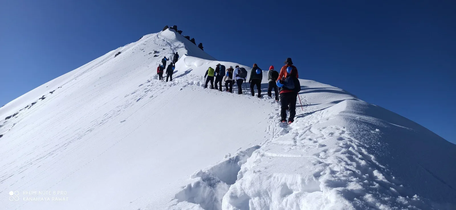
The Bali Pass Trek is one of Uttarakhand's premier high-altitude crossover expeditions, linking the Har Ki Dun valley with the sacred Yamunotri basin across Bali Pass at approximately 16,207 ft. The route traverses ancient villages, alpine meadows, dense forests, and the beautiful Ruinsara Tal before entering rugged glacial terrain near the pass.
The crossing involves steep ascents, exposed snow slopes, loose scree, and demanding high-altitude conditions, requiring strong fitness and previous Himalayan trekking experience. Throughout the journey, trekkers enjoy exceptional views of Swargarohini, Black Peak (Kalanag), Bandarpoonch, and surrounding Garhwal peaks.
Suitable only for experienced trekkers, Bali Pass offers one of the most rewarding crossover expeditions in the Indian Himalayas.
Quick Facts
Duration
Max Altitude
Difficulty
Best Time
Trek Distance
Trail Atmosphere
Stargazing
Class 1 Dark Sky
Scent Profile
Silence Level
~25 dB
Vertigo Factor
5 / 10
Iconic Spots
Bali Pass Peak (16,200 ft)
Ruinsara Tal
Environment
Nature & Culture
Flora & Fauna
Flora
Fauna
The ancient direct route connecting the Yamuna and Tons valleys. The pass offers a 360-degree 'God's eye' view of the Swargarohini, Bandarpunch, and Kalanag massifs.
— Local folklore
Spiritual & Cultural Significance
Concludes at Yamunotri, one of the Char Dham holy sites.
🕐 Shrine Timings: 06:00 AM - 08:00 PM (Yamunotri Temple)
Temple Protocols
- •Mandatory ritual bath at Tapt Kund
- •Follow silence near the Devi shrine
Festivals & Dates
Technical Details
Challenge & Preparation
Primarily a joint & muscle impact and altitude exposure challenge
A demanding expedition dominated by extreme joint & muscle impact.
Personal Readiness
Am I ready?
Planning
Logistics & Trail Intel
Getting There
Route to Base
10-hour drive from Dehradun to Sankri
Return drive from Janki Chatti is 7 hours
Base Village
Sankri (Start) / Janki Chatti (End)
6,400 ft
Nearest Railhead
Rishikesh
Nearest Airport
Jollygrant Airport
Last ATM
Purola (Not reliable). Withdraw in Dehradun.
Nearest Medical Facility
Mori PHC (22 km) / Uttarkashi District Hospital
Mobile Signal
BSNL/Jio at Sankri. Spotty signal at Osla. Zero coverage for the remaining 5 days across the pass.
Water Sources
Abundant water in Har Ki Dun valley (Tons river). Odar (cave) camp near the pass has a reliable melt-stream. Filter mandatory.
Charging
Available at Sankri (Base). Extremely limited solar/hydro charging at Osla village (courtesy). None at high camps.
For Drivers
Road Condition
Road from Purola to Sankri is narrow and prone to monsoon blocks; expect delays.
Purola
Trail Culinary & Diet
Don't miss the Garhwali Chaunsa
Buy specialized diet items at Dehradun / Mussoorie
The Content & Remote Hub
Top Vlog Spots
Video Calls
base-only
Est. 15 Mbps
UPI Reliability
2/10
Base WiFi Available
Permits and Regulations
Bali Pass is a multi-valley crossover and requires permits from two different forest ranges: Govind Wildlife Sanctuary (Sankri side) and the Yamunotri Forest Division. Permits are issued at the Netwar gate and registration at the Sankri and Janki Chatti police posts is mandatory. Indian nationals need a valid photo ID and a medical fitness certificate. Foreigners must provide passport/visa copies. Due to the technical nature of the pass, forest guards may occasionally check for specialized gear (microspikes/ropes) before allowing the crossing.
Learn more about how we vet operators and ensure transparency on our why MountRoutes page.
Packing List
Winter Clothing
- Heavy down jacket rated to -15°C
- 3 thermal base layers (full sleeve)
- 2 fleece mid layers
- Hardshell waterproof outer layer
- Trekking pants
- Woolen socks (4 pairs)
- Insulated waterproof gloves + liner gloves
- Balaclava and thermal cap
Footwear Snow Gear
- Insulated waterproof trekking boots (Vibram sole preferred)
- Professional Micro-spikes (Certified for 60-degree ice)
- High-altitude gaiters
- Camp boots
Gear Safety
- 2 Trekking poles (Anti-shock mandatory)
- Headlamp with spare batteries
- Sleeping bag rated -15°C minimum
- UV400 Polarized Sunglasses
- Sunscreen SPF 50+
- Personal medical kit
Deep Dives
Explore Further
Editor's Notes
Bali Pass is not just a 'Pass'. It's a bridge between two historical civilizations of the Supin and Yamuna valleys.
The 60-degree descent is the closest a trekker gets to an actual Mountaineering Expedition without technical climbing.
Explore In Detail
Day by Day Itinerary
8-day route reaching 16,207ft. Covers 48km of varied terrain.
→ See full itinerary with altitude profileDifficulty & Fitness
Rated challenging. Variable. Forest floor to glaciated boulders, ending in high-altitude snow fields and a technical 60-degree descent.
→ See difficulty breakdown and fitness guideCost & Pricing
Packages range from ₹18,500 – ₹32,500. Inclusions and hidden costs vary by operator tier.
→ See full cost breakdownFrequently Asked Questions
Is Bali Pass a technical trek?
It is non-technical but the final ridge crossing at 16,200 ft is very narrow and steep, requiring steady nerves.
What is the crossover route?
It connects the Tons river valley (Har Ki Dun side) to the Yamuna river valley (Yamunotri side).
Can we see the Ruinsara lake?
Yes, Ruinsara lake is a major and beautiful camping highlight on the first half of the trek.
Are microspikes needed?
Yes, absolutely. The descent on the Yamunotri side is extremely steep and icy; microspikes and trekking poles are mandatory.
Is it suitable for beginners?
No. It is a hard trek and requires prior high-altitude experience and excellent endurance.
Where is the nearest medical aid?
Janki Chatti at the end of the trek or Purola back at the base.
What is the "Odari" campsite?
Odari means "cave". It is a rocky shelter used as a camp before the final pass crossing.
Is there any mobile signal?
None. You are in deep wilderness for 6-7 days until you reach Janki Chatti.
Route Intelligence
Routes With Similar Character
Routes that share the character of Bali Pass Trek.
Buran Ghati Trek
Trekkers frequently compare these. Both demand sustained performance above 14,000 ft where altitude becomes the primary challenge.
Rupin-Supin River Trail Trek
Trekkers frequently compare these. Both demand sustained performance above 14,000 ft where altitude becomes the primary challenge.
Roopkund Trek
Both demand sustained performance above 14,000 ft where altitude becomes the primary challenge. They share multiple characteristics.
Still deciding?
Compare routes side-by-side to find the perfect match for your fitness, dates, and budget.
Everything you need to know, in one place. Someone else in your group needs to see this.
Planning Bali Pass Trek?
Get route conditions, operator updates, and season windows before booking.
Don't miss out! Follow us for route updates@mountroutes|LinkedIn
No spam. Only useful trek updates.
Ready to walk this route?
You’ve read the guide, now find the perfect local team to take you there. Compare our verified list of operators.
Compare verified operators