Essential Planning Guide
Mud to Khamengar Glacier Trek — Complete Guide (2026)
Introduction
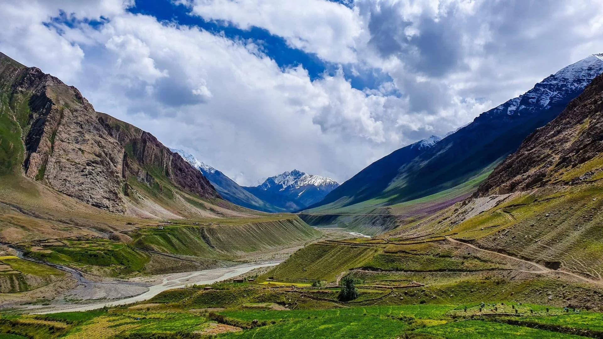
The Khamengar Glacier is a remote high-altitude glacial system deep in the Pin valley above Mud village — one of the innermost accessible glaciers in the Spiti valley system and among the least-visited glacial corridors in India. Named for its distinctive brown-and-white striped lateral moraine appearance (Khamengar from Tibetan, meaning 'striped'), this glacier sits at approximately 17,500 ft and represents the upper boundary of the Pin valley drainage system. The approach from Mud village follows the Pin river deep into the Pin Valley National Park, through landscape that intensifies progressively from the lunar brown Spitian desert at the valley floor to the extreme high-altitude glacial basin with its hanging glaciers, crevasse fields, and snow bridges. This is not a trek for casual visitors — it demands glacier travel capability, Spiti-specific acclimatization, full self-sufficiency, and excellent weather judgment. But for those who reach the Khamengar snout, the reward is a fully immersive encounter with one of India's most remote glacial environments in a landscape so raw and so still that time appears to stop completely.
Ready to book? Compare verified operators for Mud to Khamengar Glacier Trek — transparent pricing, no paid rankings.
Quick Facts
Duration
Max Altitude
Difficulty
Best Time
Trek Distance
Trail Atmosphere
Stargazing
Class 1 Dark Sky
Scent Profile
Silence Level
~0 dB
Vertigo Factor
4 / 10
Primarily a cardio demand and altitude exposure challenge
A demanding expedition with extreme cardio demand and altitude exposure.
Iconic Spots
Khamengar Glacier Snout — Striped Moraine
Blue Sheep Herds — Pin Valley Scree
Getting There
Route to Base
Kaza → Pin valley 45 km (1 hr by jeep)
Kaza is accessed from Manali (Rohtang/Atal Tunnel, 10+ hrs) or Shimla (14+ hrs)
Base Village
Mud Village, Pin Valley
13,800 ft
Last ATM
Kaza. Carry all expedition cash before entering Pin valley.
Nearest Medical Facility
Kaza CHC (1 hr back from Mud).
Mobile Signal
Mud village. Zero on trek.
Water Sources
Pin river on approach. Glacial melt streams. Carry for high camp.
Charging
Kaza guesthouse only.
For Drivers
Road Condition
Spiti road from Manali is extreme. Atal Tunnel shortens the Rohtang crossing.
Kaza
Trail Culinary & Diet
Don't miss the Tsampa with butter tea in Mud village guesthouse — the authentic Spitian high-altitude staple
Buy specialized diet items at Kaza (buy 5-day expedition rations before Pin valley entry)
The Content & Remote Hub
No DronesPVNP park regulations restrict drone use inside the sanctuary.Top Vlog Spots
Video Calls
none
Est. 0 Mbps
UPI Reliability
1/10
The Snow Leopard Probability
Key point
The Khamengar approach has the highest in-trip Snow Leopard encounter probability of any listed trek. The PVNP upper valley near the base camp is an active snow leopard kill zone — large Blue Sheep herds attract hunting leopards. Dawn observation from a concealed position on Day 2 or 3 at base camp is the optimal strategy.
Explore In Detail
Day by Day Itinerary
5-day route reaching 17,500ft. Covers 50km of varied terrain.
→ See full itinerary with altitude profileDifficulty & Fitness
Rated challenging. Desert valley walk + moraine + glacier. The glacier section is technically demanding.
→ See difficulty breakdown and fitness guideCost & Pricing
Packages range from ₹20,000 to ₹35,000. Inclusions and hidden costs vary by operator tier.
→ See full cost breakdownPermits and Regulations
Pin Valley National Park permit mandatory (DFO Kaza). PVNP-certified guide required inside the park. Full waste accountability on exit. Satellite device mandatory.
Learn more about how we vet operators and ensure transparency on our why MountRoutes page.
Packing List
Glacier Travel Mandatory
- 12-point crampons rated for glacial ice travel
- Ice axe with fully arrested training
- Rope team kit: 2x 50m ropes + harnesses + carabiners
5-Day Spiti Desert/Glacier Transition
- Extreme sun protection: SPF 100% coverage due to high UV at 17,000 ft on reflective glacier surface
- 5-day complete food self-sufficiency (no resupply in Pin valley above Mud)
- Glacier goggles (not just sunglasses) for the upper basin
Flora & Fauna
Flora
Fauna
The Khamengar glacier is called the 'Snow Lion's Mane' in Mud village Buddhist tradition — the alternating brown and white stripes representing the striped mane of the mythological snow lion of Tibetan iconography.
— Local folklore
Spiritual & Cultural Significance
Mud village has an active Spitian Buddhist gompa. Receive blessing before entering PVNP.
🕐 Shrine Timings: Mud Gompa open 8am-12pm and 3pm-5pm.
Temple Protocols
- •Remove shoes
- •Clockwise circumambulation
- •Do not touch sacred objects
Festivals & Dates
Frequently Asked Questions
What makes the Khamengar glacier visually distinctive?
The Khamengar has strongly differentiated lateral moraines with alternating brown rock and white ice bands — the striped pattern from which the Tibetan name derives. It is highly photographic and geologically unusual.
Is the Pin Valley National Park entry required?
Yes. The trek passes through PVNP and requires a park permit from the DFO office in Kaza.
What wildlife can I see on the approach?
The Pin valley is one of India's premier Snow Leopard zones. Additionally: Himalayan Wolf (very rare), Tibetan Fox, Himalayan Ibex, Blue Sheep, and the PVNP is documented for Snow Leopard in the upper valley.
Is the glacier safe to walk on?
The glacier surface is stable but requires crampons. Crevasse bridging is present — your guide must do crevasse assessment before each rope team advance.
What is Mud village like?
Mud is the last settlement in Pin valley — a dramatically-sited stone village at the mouth of the inner valley. Population approximately 100 souls. Traditional Spitian Buddhist architecture. Basic guesthouses available.
How many people do this trek each year?
Perhaps 20-40 trekkers per year reach the Khamengar glacier area — making it one of the rarest trekking destinations in India.
Are there any permanent settlements above Mud?
No. Above Mud, the Pin valley is completely uninhabited — only seasonal ranger posts at the PVNP entry.
What is the Blue Sheep density like in Pin valley?
The Blue Sheep (Bharal) population in Pin valley PVNP is among the highest in India. Groups of 50-100 Bharal are routinely observed on the valley scree slopes.
Can I see the glacier from Mud village?
Only the very distant glacier peaks from Mud. The glacier itself is concealed in the inner valley 20+ km from Mud.
What is the most critical gear item?
Glacier goggles. Without category 4 glacier goggles, the UV exposure on the reflective glacier surface at 17,000 ft will cause severe snow blindness within hours.
What makes the Khamengar Glacier trek one of the hardest in Spiti?
The trek involves crossing the massive, highly active, and deeply crevassed Khamengar Glacier at over 16,000 ft, navigating loose moraine walls, and enduring extreme cold and wind chill in complete isolation.
Is there any evacuation option in Khamengar Valley?
Evacuation is exceptionally difficult. Helicopter rescue is the only viable option for critical emergencies, requiring manual transport to a flat glacial zone where the heli can land.
How do we cross the glacial melt rivers in Spiti?
River crossings must be completed early in the morning before 8 AM. By afternoon, the sun melts the glacier ice, turning shallow streams into raging, impassable torrents.
What is the cell signal situation on the Spiti side?
Mud village has basic BSNL/Jio connectivity. Once you enter the Khamengar gorge, you will experience absolute radio silence with zero cellular network.
Do we need high-altitude wilderness permits?
Yes, wildlife sanctuary and inner line permits are required from the SDM office in Kaza before entering the remote valleys bordering Spiti.
Other Treks Guides
Still deciding?
Compare routes side-by-side to find the perfect match for your fitness, dates, and budget.
Everything you need to know, in one place. Someone else in your group needs to see this.
Planning Mud to Khamengar Glacier Trek?
Get route conditions, operator updates, and season windows before booking.
No spam. Only useful updates.
Ready to walk this route?
You’ve read the guide, now find the perfect local team to take you there. Compare our verified list of operators.
Compare verified operators