Essential Planning Guide
Bisuri Tal Trek — Complete Guide (2026)
Introduction
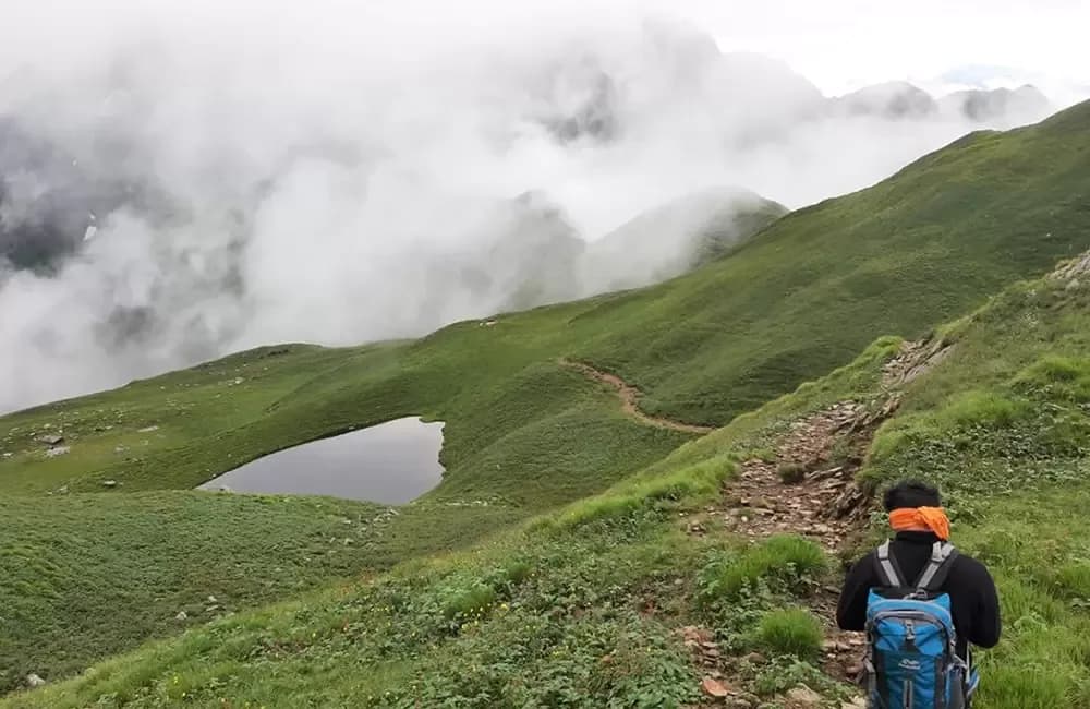
Bisuri Tal is a high-altitude lake hidden in a lateral ridge above Chopta — the famous 'mini Switzerland of Uttarakhand' and base for the Tungnath–Chandrashila trek. While the Tungnath–Chandrashila route has become one of Uttarakhand's most visited mountain experiences (with 50,000+ annual visitors), the Bisuri Tal sits in a completely different direction from Chopta, reached by an unmarked 4-hour climb through dense rhododendron and oak forest into a hidden bowl at 12,800 ft. The lake itself — roughly 200m across — occupies a perfect glacial hollow surrounded by moss-covered granite and seasonal wildflowers, with Kedarnath Peak (6,940m) and the Kedarnath Dome visible behind it on clear mornings. Almost no commercial trek covers this route: it is unknown beyond local Chopta shepherd and shepherd-guide community. Yet from Chopta (the most accessible high-altitude base in Garhwal at 8,790 ft by motor road), Bisuri Tal is reached in 4 hours of forest walking — the easiest gateway to a genuinely secret Himalayan experience in this database.
Ready to book? Compare verified operators for Bisuri Tal Trek — transparent pricing, no paid rankings.
Quick Facts
Duration
Max Altitude
Difficulty
Best Time
Trek Distance
Trail Atmosphere
Stargazing
Class 1 Dark Sky
Scent Profile
Silence Level
~5 dB
Vertigo Factor
1 / 10
Primarily a joint & muscle impact and cardio demand challenge
A capable trekker's route dominated by extreme joint & muscle impact.
Iconic Spots
Bisuri Tal Dawn Kedarnath Reflection
Rhododendron Tunnel Approach (April)
Getting There
Route to Base
Rishikesh → Rudraprayag → Ukhimath → Chopta (215 km, 7–8 hrs)
Shared taxis from Ukhimath to Chopta available
Nearest rail: Haridwar (207 km)
Nearest airport: Jolly Grant Dehradun (245 km)
Chopta is one of the most road-accessible high-altitude bases in Garhwal
Base Village
Chopta (8,790 ft), Rudraprayag District
8,790 ft
Last ATM
Ukhimath (35 km from Chopta). Carry cash from Ukhimath or Rudraprayag.
Nearest Medical Facility
Ukhimath Community Health Centre (35 km, 1 hr). Rudraprayag District Hospital (90 km, 3 hrs).
Mobile Signal
Chopta only (Jio 4G). Zero on trail.
Water Sources
Lake water (treat — livestock grazing in surrounding meadows). Small stream below the lake bowl on the descent trail. Carry 2L from Chopta for the ascent.
Charging
Chopta guesthouses. Zero on trail.
For Drivers
Road Condition
Rishikesh to Ukhimath is well-paved mountain highway. Ukhimath to Chopta (35 km) is paved but narrow, with potential snow closure November–March.
Ukhimath (35 km from Chopta)
Trail Culinary & Diet
Don't miss the Chopta dhaba aloo ke gutke (spiced mountain potatoes with local herbs) — a classic Garhwali trail snack, best eaten at a Chopta dhaba on return from the lake.
Buy specialized diet items at Rudraprayag town (60 km from Chopta). Chopta dhabas serve simple vegetarian mountain food (dal, rice, aloo paratha, Maggi). Excellent for standard needs.
The Content & Remote Hub
Top Vlog Spots
Video Calls
none
Est. 0 Mbps
UPI Reliability
5/10
The Reflection Window Secret
Key point
Your Chopta guide knows the exact 90-minute window. The lake surface is mirror-still specifically between 5:30am and 7:00am before the morning breeze from the northeast (coming over the Kedarnath range) begins to disturb the surface. After 7:00am the reflection breaks and the image becomes rippled. The guide will have a specific weather-reading habit — watching the tree tips at the lake bowl rim for wind direction at 5am before confirming it's the right morning.
Explore In Detail
Day by Day Itinerary
5-day route reaching 13,100ft. Covers 28km of varied terrain.
→ See full itinerary with altitude profileDifficulty & Fitness
Rated moderate. Dense rhododendron and oak forest (0–2.5 km from Chopta, steep and rooted), open meadow approach (2.5–5 km, moderate gradient), final lake bowl rim (rocky, short scramble). No technical terrain. Trail unmarked throughout — orientation by local knowledge required.
→ See difficulty breakdown and fitness guideCost & Pricing
Packages range from ₹4,000 – ₹10,000. Inclusions and hidden costs vary by operator tier.
→ See full cost breakdownPermits and Regulations
No formal permit required. Bisuri Tal is outside the formal Kedarnath Wildlife Sanctuary boundary at this access altitude. Informal registration at Chopta chowkidar or forest check post before leaving. Carry all waste out — no infrastructure at the lake. Gas stove only — open fires prohibited near the lake/rocky bowl zone.
Learn more about how we vet operators and ensure transparency on our why MountRoutes page.
Packing List
Forest Trek Essentials
- Waterproof boots — dense rhododendron forest is consistently damp even in dry season
- Trekking poles — upper approach has steep root sections
- Rain shell — Chopta area has localized mist showers even on clear days
Lake Camp
- 3-season tent — Bisuri Tal is open and wind-exposed; stake points essential
- Down sleeping bag (-10C rated) — night temperatures at 12,800 ft drop sharply even in June
- Lake photography kit — tripod for reflection shots at dawn
Flora & Fauna
Flora
Fauna
Chopta-area shepherds believe Bisuri Tal is inhabited by a nag devta (serpent deity) who keeps the lake still at dawn as an offering prayer — explaining the perfect mirror reflection condition. The morning stillness is called 'nag ka puja' (the serpent's prayer).
— Local folklore
Spiritual & Cultural Significance
Adjacent to the Kedarnath Wildlife Sanctuary spiritual buffer zone. Kedarnath Peak visible from the lake is itself a sacred Shiva symbol. Chopta is a significant religious waypoint on the Tungnath pilgrimage circuit.
🕐 Shrine Timings: Tungnath Temple (nearby): 6am–3pm (May opening to October closing). Bisuri Tal itself: no shrine.
Temple Protocols
- •If combining with Tungnath: remove shoes at temple entry, observe prayer protocols during puja times
Festivals & Dates
Frequently Asked Questions
Is Bisuri Tal near Tune/Tungnath?
Yes — both trails start from Chopta. Tungnath is northeast of Chopta; Bisuri Tal is in a separate lateral direction (northwest). They share the same road-accessible base but are completely different trails.
How many people visit Bisuri Tal each year?
Estimated 50–150 visitors annually — less than a single day's Tungnath visitor count. The trail is not marked and not published by commercial operators.
Is the lake always accessible from Chopta?
Season is May–November. December–April the trail is under heavy snow. Chopta road itself can be snow-blocked November–April.
What is the trail like?
Unmarked shepherd path through dense rhododendron and oak forest for 3 km, then open meadow approach for 2 km, then a final rocky bowl rim to the lake. Total 7 km, 4,000 ft ascent.
Can I do this as a day trip from Chopta?
Technically possible (7 km one way, 4 hrs up) but the dawn lake reflection is worth camping. The trail also requires finding the correct path through dense forest — a guide for the first visit is recommended.
What views does the lake have?
The lake bowl faces northeast — on clear mornings, Kedarnath Peak (6,940m) and the Kedarnath Dome massif are reflected in the lake. A private reflection shot of Kedarnath from a secret unmarked lake: no internet image of this exists.
Is camping allowed at the lake?
Bisuri Tal is outside the Kedarnath Wildlife Sanctuary boundary at this altitude. No formal permit required. Register at Chopta check post informally.
Who knows this trail?
Chopta-area bugyal shepherds and a handful of local nature guides. The nearest commercial operator to document this route is Ukhimath or Chopta homestay guides who work informally.
What wildflowers are at the lake?
Brahma Kamal around the lake shore (late July–August), Himalayan Buttercup, Primula, and rhododendron bloom in the forest below (April–May). The combination of rhododendron forest below and Brahma Kamal near the lake makes this a two-season wildflower trek.
Are there any facilities?
Zero. Bisuri Tal has no tea shop, no toilet, no camping infrastructure. Chopta has excellent guesthouses and dhabas as base.
Other Treks Guides
Still deciding?
Compare routes side-by-side to find the perfect match for your fitness, dates, and budget.
Everything you need to know, in one place. Someone else in your group needs to see this.
Planning Bisuri Tal Trek?
Get route conditions, operator updates, and season windows before booking.
No spam. Only useful updates.
Ready to walk this route?
You’ve read the guide, now find the perfect local team to take you there. Compare our verified list of operators.
Compare verified operators