Detailed Route
Bisuri Tal Trek Itinerary — Day by Day Route & Camps
A 2-day (optionally 3-day) camp-and-return from Chopta to a secret glacial lake at 12,800 ft, with optional Tungnath–Chandrashila extension on Day 3.
Standard RouteThis is the standard mountain pacing for this trek. Specific operators may add an acclimatization day or alter the starting point. Check individual operator schedules for their exact logistics.
Duration
5 Days
Total Distance
28 KM
Max Altitude
13,100 FT
Trek Type
circuit
Day by Day Breakdown
Drive: Rishikesh to Chopta
Pick up from Rishikesh by 8:00 AM. Drive along the holy Ganges and Alaknanda rivers. Last reliable ATM at Ukhimath. Night stay in a homestay/guesthouse.
Key Landmarks
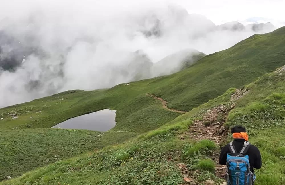
Chopta to Bisuri Tal
Start at 7am from Chopta. The first 2 km through rhododendron forest is steep and consistently damp. Emerge to open meadow at 11,500 ft — the first views of the Garhwal peaks. Final approach over the lake bowl rim at 12,500 ft reveals the lake with a dramatic suddenness. Set up camp early, explore shore, photograph. Night at lake.
Key Landmarks
Staying At
Dawn Photography, Lake Exploration, Return to Chopta
4:30am wake. Lake shore for dawn reflection window (5:30–7:00am). After 7am, explore lake rim (1 km circuit) and identify wildflower species. Pack camp by 10am. Relaxed descent to Chopta by 2pm. Evening at Chopta — excellent dhabas for hot meal.
Key Landmarks
Staying At
Optional: Tungnath–Chandrashila Summit from Chopta
Optional extension combining Bisuri Tal with Tungnath–Chandrashila. The famous sunset from Chandrashila (Kedar Dome, Trishul, Nanda Devi, Bandarpunch, Kala Nag all visible) makes this a powerful 3-day Chopta combination. Return to Chopta same day.
Key Landmarks
Drive to Rishikesh
Start early for sunrise. Trail to Tungnath (highest Shiva temple) is well-paved. The final 1km from temple to peak is steep. Summit offers 360-degree Himalayan views. Descend to Chopta and drive back to Rishikesh. Reach by 10 PM.
Trek Extensions & Add-ons
Tungnath–Chandrashila Same-Day Add-on
+1 DayAfter returning to Chopta on Day 2 afternoon, use Day 3 for Tungnath Temple (12,073 ft, world's highest Shiva temple) and Chandrashila summit (13,100 ft). The two-peak combination — secret Bisuri Tal + famous Chandrashila — from the same Chopta base delivers the complete spectrum of Chopta's offering in 3 days total.
Deoria Tal Circuit (Pre-Trek)
+2 DaysBefore Bisuri Tal, 2 days at Deoria Tal — the famous Garhwal lake with Chaukhamba reflection from Sari village (10 km from Ukhimath). Combine Deoria Tal (famous) + Bisuri Tal (secret) + Tungnath (iconic) for the ultimate Rudraprayag district 5-day circuit.
Also on this trek
Ready to book? Compare verified operators for Bisuri Tal Trek — transparent pricing, no paid rankings.
Still deciding?
Compare routes side-by-side to find the perfect match for your fitness, dates, and budget.
Day by day, camp by camp. Send this to your group so everyone's on the same page.
Love this itinerary?
Find operators who follow this exact route with verified acclimatization days.
Find matching operators