Difficulty & Readiness Guide
Is Bisuri Tal Trek Difficult? — Fitness & Altitude Guide
An easy-moderate 2-day forest and meadow trek to a secret lake at 12,800 ft near Chopta. The 4,000 ft gain over 7 km and unmarked trail are the primary challenges — a local guide is essential on first visit.
Preparation Required
Intermediate
Prior Experience
Recommended: 1-2 easy Himalayan treks or regular hiking experience.
Score Engine v3
Why This Score?
Stamina
27/100
Based on average nightly altitude gain, highest campsite, and daily distance. Reflects how hard the average day feels.
Spike Day
52/100
Based on max altitude reached, summit day elevation gain, and summit day distance. Reflects the hardest single day.
Why Bisuri Tal Trek Feels Difficult
A capable trekker's route dominated by extreme joint & muscle impact.
Physiological Demand
Steep, punishing ascents and descents that will heavily tax your knees, ankles, and overall joint stability.
Expect long, exhausting days of sustained climbing at high intensity. Your cardiovascular system will be pushed to its absolute limit.
Significant time spent above 12,000ft. Expect shortness of breath and slower pacing.
Rough, uneven trails with occasional scrambling or minor exposure.
Comfortable pacing with good recovery options.
Crux Section
Day 4 — Oxygen Peak
Highest exposure point at 13,100ft.
Bisuri Tal Trek/ 47
The Forest Navigation Problem
Caution
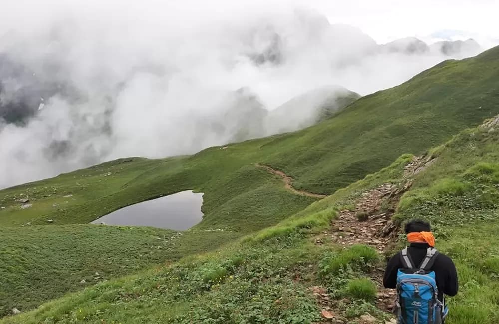
The rhododendron forest between 9,500 and 11,000 ft has at least 4 branching livestock trails. Two of them dead-end at cliff edges above the drainage. One leads northwest toward a completely different ridge. Only one is the Bisuri Tal approach. The trails are not marked and the vegetation blocks sight lines beyond 20m. This is why local guide knowledge is critical on first visit.
Terrain Breakdown
Dense rhododendron and oak forest (0–2.5 km from Chopta, steep and rooted), open meadow approach (2.5–5 km, moderate gradient), final lake bowl rim (rocky, short scramble). No technical terrain. Trail unmarked throughout — orientation by local knowledge required.
Summit Day Notes
Not a summit day — Bisuri Tal is reached as a camp destination. The lake bowl rim (12,500–12,800 ft) requires a short rocky step-up (15 minutes) but is not technical. The total altitude gain of 4,000 ft over 7 km is the main challenge.
The Descent
Forest descent (Day 2) is slippery in wet conditions and in morning dew. Trekking poles essential on the steep rooted section. Add 30 minutes more than ascent time for safe descent.
Preparation
Basic fitness sufficient. The 4,000 ft gain over 7 km in 4 hours is the steepest requirement. No altitude exposure above 13,000 ft. The forest section is the most physically demanding — steeper than expected.
Altitude Profile
One night at 12,800 ft. Well within safe range for fit adults without prior acclimatization. Chopta itself at 8,790 ft serves as a natural day-long acclimatization via the drive from Ukhimath.
Run AMS Risk Audit →Route Stress Forecast
Highest exposure point at 13,100ft.
Deep 4,310ft descent will test joint stability.
First major altitude jump occurs on Day 2.
*Forecast derived from route geometry and altitude profile. External variables (weather/group) remain the final authority.
Trail Performance Data
Max Gradient
55%
Hydration
0.35L per km recommended
Loose Surface Sections
- •Rhododendron forest section (wet roots and leaf litter)
- •Lake bowl rim rocky scramble (short, 15 minutes)
Common Mistakes on Bisuri Tal Trek
Most injuries and failures on this trail can be avoided by making smarter decisions early on.
Arriving at the lake after 11am and missing the still-water reflection window
Attempting without a local guide on first visit — the trail branches in the forest zone without obvious indicators
Not bringing a headlamp for the 4:30am lake dawn session
Safety & Medical Risks
Key Risks
Getting lost in the dense rhododendron forest (trail branches multiple times — unmarked)
Sudden weather change at lake bowl (open and exposed — seek shelter behind boulder on far shore)
Night temperature drop at 12,800 ft — more severe than expected, especially April–May and October
AMS (Altitude Sickness)
AMS risk minimal at 12,800 ft for fit adults. Chopta at 8,790 ft by motor road provides natural acclimatization. Spend minimum 3–4 hours at Chopta before ascending.
Evacuation Route
Retrace to Chopta (4 hrs, 7 km). Motor vehicle access at Chopta. Patient to Ukhimath CHC (35 km by road).
Solo Trekking
Possible but not recommended without prior visit. The forest zone trail-finding is genuinely complex on first attempt — invest in local guide for safety and route knowledge.
Common Trail Ailments
🏥 Nearest ICU: AIIMS Rishikesh / Max Super Specialty Hospital, Dehradun
Tactical Emergency Hub
> Retrace to Chopta on foot (4 hrs). Motor accessible at Chopta for patient transport to Ukhimath CHC (35 km). No helicopter access at lake bowl.
Who Can Do This Trek?
Min Age
10+
Max Age
65
Western Toilets at Base
Yes
Solo Female Travelers
Chopta is one of the safest tourist bases in Garhwal — well-organized guesthouse community, regular police presence during season. Bisuri Tal trail is isolated but manageable with guide.
Expert Verdict
Highly technical trek requiring physical and mental preparation.
Ready to book? Compare verified operators for Bisuri Tal Trek — transparent pricing, no paid rankings.
Want to know which operators carry certified guides and medical support? See operator safety ratings for Bisuri Tal Trek
Also on this trek
Still deciding?
Compare routes side-by-side to find the perfect match for your fitness, dates, and budget.
Still think it's doable? Share this with your trek mate and see if they agree.
Fit for the challenge?
For challenging treks, safety is paramount. Find operators prioritizing medical support and guide expertise.
Compare operator safety scores