Explore
Intelligence
Difficulty & Readiness Guide
Is Bali Pass Trek Difficult? — Fitness & Altitude Guide
Bali Pass Trek is graded Hard — the 5-hour technical snow climb to the 16,207ft col is the most punishing section.
The Question
Can I do this trek?
Preparation Required
Advanced
Prior Experience
Required: At least 2-3 moderate Himalayan treks (above 13,000ft).
Expert Verdict
Highly technical trek requiring physical and mental preparation.
Bali Pass Trek
Himalayan Placement · Index 58Route Knowledge
Why is it difficult?
Exertion Index
Primary Challenge
Route Identity
High-impact route characterised by steep gradients and heavy joint loading across a pass-crossing route featuring scrambling and loose moraine.
Primary Drivers
- Maximum sleeping altitude of 15,100 ft
- 3 consecutive high-output trekking days
- Peak daily distance of 14 km
View Full Route Analysis
Physiological Demand
Steep, punishing ascents and descents that will heavily tax your knees, ankles, and overall joint stability.
Significant time spent above 12,000ft. Expect shortness of breath and slower pacing.
Multi-day camping requiring mental toughness to handle weather and fatigue debt.
Challenging daily distances and steady climbs. Good cardiovascular fitness is required.
Rough, uneven trails with occasional scrambling or minor exposure.
Terrain Breakdown
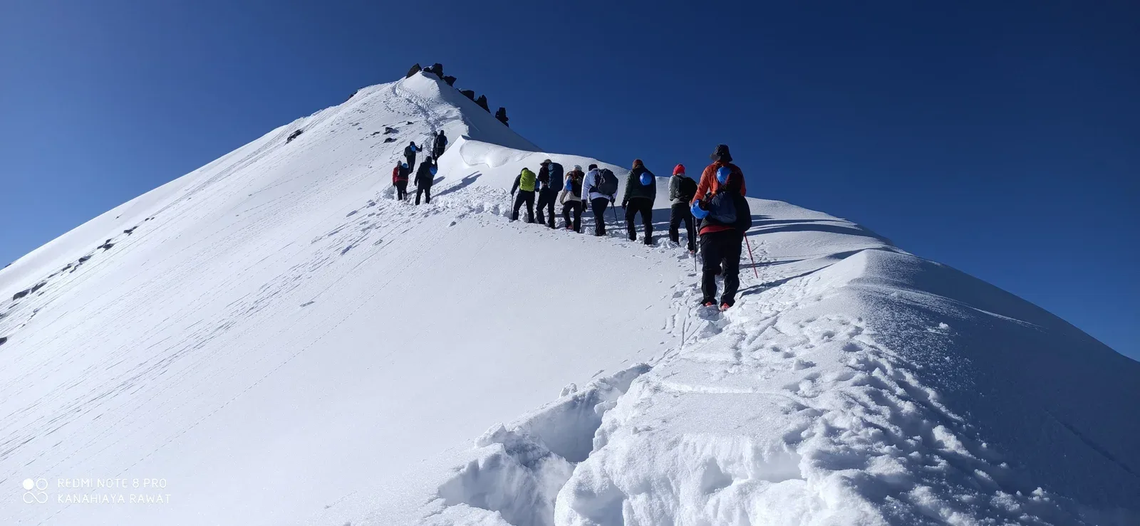
Variable. Forest floor to glaciated boulders, ending in high-altitude snow fields and a technical 60-degree descent.
Summit Day Notes
16,207ft. The air has 55% of sea-level oxygen. The vertical descent towards Yamunotri requires specialized focus and ropes.
The Descent
The most technical descent in the Govind WLS. Not for those with vertigo or weak knees.
Altitude Profile
11.8k -> 13.1k -> 15.1k -> 16.2k. This is a massive jump. Hydration is the only survival key.
Run AMS Risk Audit →Trail Performance Data
Max Gradient
60%
Hydration
0.6L per km recommended
Loose Surface Sections
- •Final 500m pass ascent
- •Technical snow bridge crossings
Personal Readiness
Am I ready?
What this route demands
People who feel comfortable on this route can usually:
Who Can Do This Trek?
Min Age
15+
Max Age
50
Western Toilets at Base
Yes
Solo Female Travelers
Moderate; the Har Ki Dun valley is very social, but the pass crossing is extremely remote. Group trekking is highly advised.
Hazard Profile
What goes wrong?
Common Mistakes on Bali Pass Trek
Most injuries and failures on this trail can be avoided by making smarter decisions early on.
Taking beginners — this is an expert trek. Retreat rate is 40%.
Using mesh sneakers — you need waterproof, high-ankle support for the pass snow.
Not checking professional crampons/spikes in Sankri.
Skipping the Odari rest day — primary cause of AMS-induced failure.
Rushing the descent slope — one slip can lead to a 500m uncontrolled slide.
Inadequate hydration — failure to drink 5L water at 15k is the #1 medical risk.
Safety & Medical Risks
Key Risks
Technical 60-degree descent on scree/snow
AMS (Acute Mountain Sickness) at 16,000ft
Extreme wind chill at Col Camp (-15C)
River crossing instability near Rain Basera
AMS (Altitude Sickness)
Acclimatization day at Ruinsara Tal is mandatory. Drink 5L water. Monitor pulse tonight at Odari.
Evacuation Route
Manual stretcher to Seema or Janki Chatti. Heli-evacuation from Seema helipad.
Solo Trekking
STRICTLY NOT RECOMMENDED. The descent is lethal for solo hikers without a rope-lead. Permits for solo crossover are usually denied.
Common Trail Ailments
🏥 Nearest ICU: AIIMS / SGRR Medical College, Dehradun
Tactical Emergency Hub
> Extremely difficult. 2 days to Sankri or Yamunotri roadhead. Dehradun (Max/AIIMS) is the primary critical care hub via heli-evac.
Auditability
How is this calculated?
Understand This Route Further
Before attempting this route:
Still deciding?
Compare routes side-by-side to find the perfect match for your fitness, dates, and budget.
Still think it's doable? Share this with your trek mate and see if they agree.
Step 2: Seasonal Safety
You know how demanding this route is.
Now find the safest and most reliable season to attempt it.
Check Best Time to Go