Explore
Intelligence
Detailed Route
Bali Pass Trek Itinerary — Day by Day Route & Camps
Bali Pass Trek is an 8-day Yamunotri-to-Sankri crossing, with the demanding 16,207ft pass summit reached on Day 5.
Standard RouteThis is the standard mountain pacing for this trek. Specific operators may add an acclimatization day or alter the starting point. Check individual operator schedules for their exact logistics.
Duration
8 Days
Total Distance
48 KM
Max Altitude
16,207 FT
Trek Type
linear
Day by Day Breakdown
Camp Alt
6,400 ft
Day Gain
+4,300 ft
Drive to Sankri
Pick up at 7:00 AM. Guesthouse stay. Use this day to register with the Forest Dept. Technical: A massive drive through winding river valleys. The Netwar section is the transition from standard villages to the tribal Supin valley. Avoid heavy meals before the Mori-Sankri hairpins. Safety: Final gear check in Sankri. If you are missing microspikes or a headlamp, buy/rent them in the village market tonight.
Key Landmarks
The scenery transitions from urban foothills to dense pine forests as the road gains elevation. Approaching Purola, the landscape opens into wide agricultural valleys, later replaced by the deep, forested gorge of the Supin river. The final stretch to Sankri enters a section of the valley, marked by traditional wooden architecture and the distinct culture of the upper Garhwal region.
Camp Alt
8,200 ft
Day Gain
+1,800 ft
Drive to Taluka & Trek to Seema
First night in tents at Seema. Excellent for river-side acclimatization. Technical: Level trail along the Supin river. Mostly dusty path but some slippery sections near river bridge crossings. Keep a steady pace; save energy for the 14k+ gain later. Safety: Taluka road is landslide-sensitive. If blocked, expect to trek on the road. Keep rain-covers handy.
Key Landmarks
Staying At
The initial drive is bumpy but reveals the ruggedness of the Supin valley. On the trail, the constant roar of the river provides a steady backdrop. The path alternates between shaded forest sections and open clearings, offering glimpses of traditional wooden houses clinging to the hillside across the valley.
Camp Alt
9,930 ft
Day Gain
+1,730 ft
Reach Rain Basera
The trail diverts from the core Har Ki Dun path. Significant climb through switchbacks. Terrain is root-heavy and muddy in sections. Crossing the river via a log bridge (if not washed away).
Key Landmarks
Staying At
Leaving the main trail, trail traffic descends significantly and the environment becomes noticeably . The dense forest canopy provides deep shade and the terrain underfoot becomes rugged. Emerging from the forest near Rain Basera, the valley narrows significantly, dominated by the rushing water of the Ruinsara Gad and surrounded by steep, sheer valley walls.
Field Notes
KEY ACTIONRiver Crossings
Plan to cross early in the day before snowmelt swells the water levels. Unclip backpack waist belts before crossing.
Camp Alt
11,811 ft
Day Gain
+1,881 ft
Reach Ruinsara Tal
One of the most beautiful campsites in the Himalayas. 360-degree peak views. Technical: Steep climb into the high-alpine zone. The trail is often covered in rhododendron debris. Reach the lake for an afternoon rest. Low oxygen starts to take effect at 11,800ft. Safety: Stay hydrated with 5L water. The jump to 11.8k is significant. Monitor pulse oximetry tonight.
Key Landmarks
Staying At
The forest gradually gives way to open alpine meadows and broad valley views. The landscape widens to reveal sweeping meadows framed by the massifs of Swargarohini and Black Peak. Ruinsara Tal occupies the center of the basin beneath the surrounding peaks.
Field Notes
KEY ACTIONRiver Crossings
Plan to cross early in the day before snowmelt swells the water levels. Unclip backpack waist belts before crossing.
Camp Alt
13,100 ft
Day Gain
+1,289 ft
Reach Odari
The 'Col' (Pass) is now visible. Nervous energy at camp is common. Technical: Short but steep distance. Moving across glaciated boulders. The 'Rock Cave' acts as a wind-deflector for the camp. Cold winds are constant here. Safety: Temps drop to -10C at Odari. Check for symptoms of AMS (HACE/HAPE) before sleeping. Descend back to Ruinsara if necessary.
Key Landmarks
Staying At
The physical environment is defined by dropping temperatures and constant cold winds across a landscape of rock, ice and snow. The Bali Pass ridge becomes clearly visible above camp, while surrounding vegetation disappears entirely from the landscape.
Field Notes
Stow Poles
Requires hands-on rock scrambling. Stow trekking poles to free up your hands.
INFOSlower Progress
Progress will be significantly slower and more taxing on your ankles than trail distance suggests.
Camp Alt
15,100 ft
Day Gain
+2,000 ft
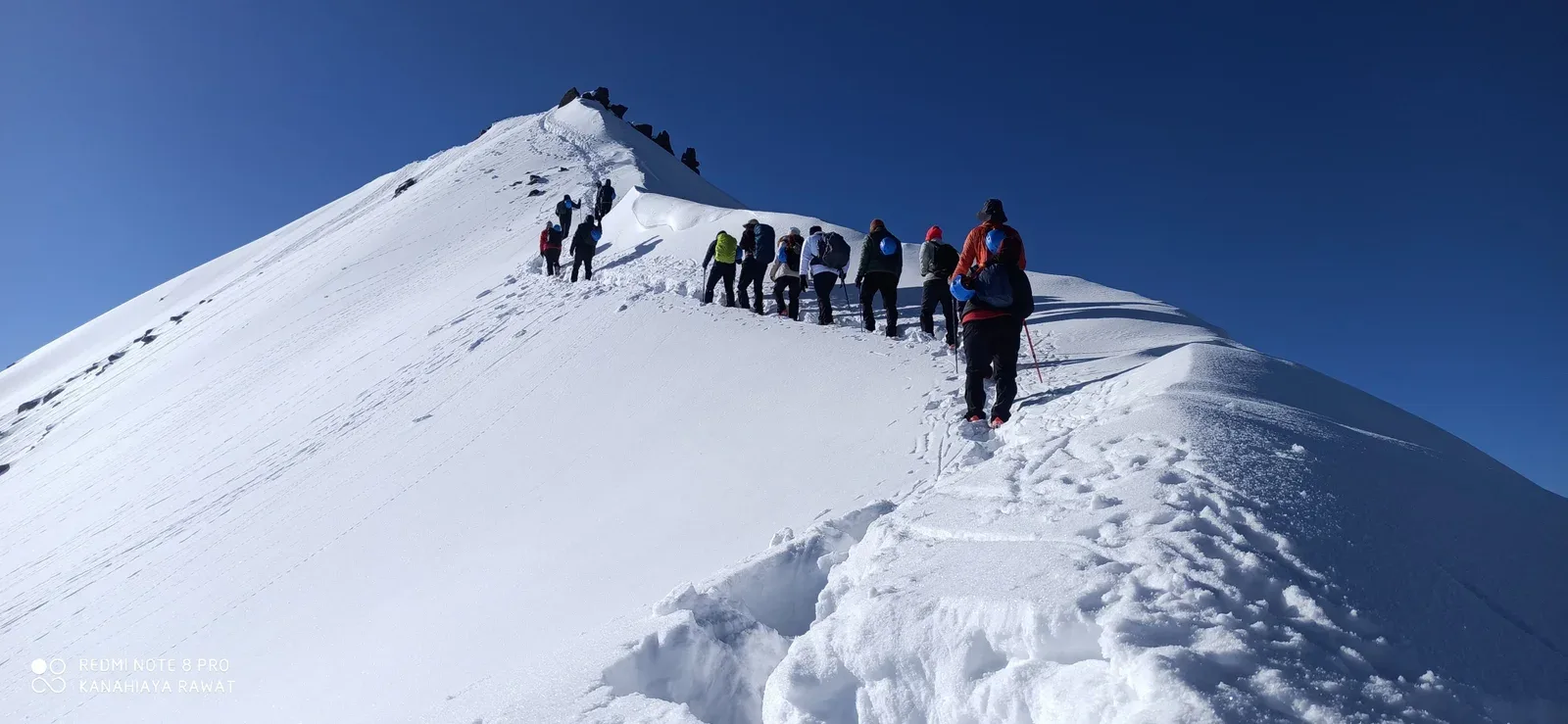
Reach Bali Pass Base Camp
Early dinner. Wake up at 2:30 AM for the 4:00 AM push. Technical: Extreme climb on scree and snow. You are essentially camping on the ledge of the pass. Tents are anchored on small stone platforms. Oxygen level is approx 55% of sea level. Safety: Strict 'No-Exertion' rule at camp. Conserve energy. Use Diamox if prescribed. Night temps -15C.
Key Landmarks
Staying At
The route leaves the last vegetated slopes and enters a barren alpine zone dominated by rock, snow and ridgelines. The campsite itself is open to the high Himalayan winds, offering views backward toward the Ruinsara valley.
Field Notes
Use Trekking Poles
Trekking poles are highly recommended to save your knees on the descent.
INFOSlower Progress
Progress will be significantly slower and more taxing on your ankles than trail distance suggests.
Camp Alt
11,100 ft
Day Gain
-4,000 ft
Today's Objective
🏔 Cross Bali Pass
Reach Lower Dhamni by 4 PM. Celebration of survival and summit! Technical: Summit push is on hard snow. The crux is the descent towards Yamunotri: A 60-degree drop on snow/scree. Ropes and microspikes are mandatory. Don't look down; focus on your footwork. Safety: Descent Alert: 80% accidents occur here. Never descend alone. One slip on the scree requires an immediate self-arrest (Ice-axe/Poles).
Key Landmarks
Staying At
Reaching the pass marks a sharp transition between two distinct Himalayan valleys, presenting close-up views of the Swargarohini and Bandarpoonch massifs. The descent follows a steep snow and scree gully before entering the upper forests of the Yamunotri valley. As the route descends into Lower Dhamni, the return of vegetation and warmer air signals the end of the high-altitude glacial basin.
Field Notes
Use Trekking Poles
Trekking poles are highly recommended to save your knees on the descent.
INFOSlower Progress
Progress will be significantly slower and more taxing on your ankles than trail distance suggests.
Camp Alt
2,100 ft
Day Gain
-9,000 ft
Trek to Janki Chatti & Drive to Dehradun
Long descent to the main Yamunotri trail. Janki Chatti is a tourist hub. Drive 7 hours back to Dehradun.
The forest trail merges with the paved Yamunotri pilgrim route near Janki Chatti, introducing a noticeably busier environment. The air becomes noticeably thicker and warmer as altitude drops. The subsequent drive traces the winding path of the Yamuna river, marking a gradual return from the mountains to the plains of Dehradun.
Field Notes
KEY ACTIONRiver Crossings
Plan to cross early in the day before snowmelt swells the water levels. Unclip backpack waist belts before crossing.
Trek Extensions & Add-ons
Har Ki Dun Valley stay
+1 DayExtra day to explore the ancient wooden village of Osla and the Har Ki Dun amphitheatre before the pass ascent.
Plan Your Trek:
Ready to book? Compare verified operators for Bali Pass Trek — transparent pricing, no paid rankings.
Still deciding?
Compare routes side-by-side to find the perfect match for your fitness, dates, and budget.
Day by day, camp by camp. Send this to your group so everyone's on the same page.
Step 4: Cost & Logistics
You understand the route.
Now see what services, permits, and logistics actually cost.
View Cost Breakdown