Essential Planning Guide
Ali & Bedni Bugyal Trek — Complete Guide (2026)
Introduction
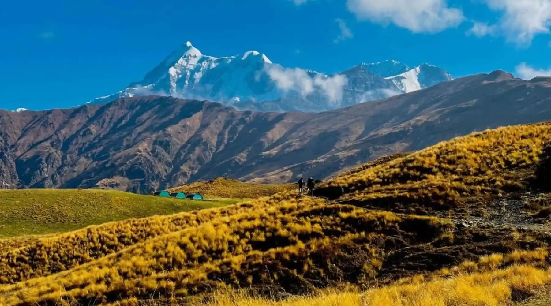
The Bedni & Ali Bugyal trek is arguably the greatest high-altitude meadow walk in the Indian Himalayas. Functioning visually as a safer, physically moderate alternative to the full Roopkund expedition, this trek focuses entirely on the sheer glory of the twin alpine meadows: Ali Bugyal and Bedni Bugyal. Starting from the central trekking hub of Lohajung, trekkers plunge into deep, ancient oak forests before climbing steeply out of the tree line at 11,300 ft directly onto the rolling, endless green carpet of Ali Bugyal. From Ali, it is a magnificent ridge walk across the meadows to Bedni Bugyal. Standing upon Bedni, the western face of Mt. Trishul (7,120m) and Nanda Ghunti erupt into the sky, feeling so close you could practically touch them. It provides world-class Himalayan scale without the extreme physical danger and altitude sickness risks associated with crossing 14,000 ft.
Ready to book? Compare verified operators for Ali & Bedni Bugyal Trek — transparent pricing, no paid rankings.
Quick Facts
Duration
Max Altitude
Difficulty
Best Time
Trek Distance
Trail Atmosphere
Stargazing
Class 1 Dark Sky
Scent Profile
Silence Level
~25 dB
Vertigo Factor
1 / 10
Primarily a cardio demand and joint & muscle impact challenge
A capable trekker's route that balances cardio demand and joint & muscle impact.
Iconic Spots
Ali Bugyal Tree-line Exit
Getting There
Route to Base
Train to Kathgodam, followed by shared cabs operating extensively up to Lohajung via Almora and Gwaldam
Base Village
Lohajung
7,600 ft
Last ATM
Dewal (1 hour before Lohajung)
Nearest Medical Facility
Dewal / Tharali
Mobile Signal
Total dark zone past Didina.
Water Sources
Streams exist near the campsites in the tree line. Zero water on the bugyal itself.
Charging
Zero charging after Lohajung.
For Drivers
Road Condition
Kathgodam to Lohajung is exhausting. Frequent roadworks near Tharali/Dewal.
Dewal
Trail Culinary & Diet
Don't miss the N/A
Buy specialized diet items at Lohajung
The Content & Remote Hub
No DronesDrones are generally banned inside the Nanda Devi Biosphere reserve areas.Top Vlog Spots
Video Calls
none
Est. 0 Mbps
UPI Reliability
1/10
Guide Wisdom
Caution
Start climbing out of Didina at 6:00 AM. It is a grueling, dark ascent, and if you hit the treeline after 11 AM, the afternoon clouds will block your first view of Trishul entirely.
Explore In Detail
Day by Day Itinerary
6-day route reaching 11,500ft. Covers 38km of varied terrain.
→ See full itinerary with altitude profileDifficulty & Fitness
Rated moderate. The forest sections (up from Didina and down to Wan) are extremely steep, testing cardiovascular endurance and knee strength. The bugyal itself is a gentle, rolling carpet.
→ See difficulty breakdown and fitness guideCost & Pricing
Packages range from ₹7,000 to ₹10,000. Inclusions and hidden costs vary by operator tier.
→ See full cost breakdownPermits and Regulations
Strict Nanda Devi Biosphere and forest dept permits are required from Lohajung. Ecological conservation rules are heavily enforced; zero plastic tolerance and strictly regulated camping zones.
Learn more about how we vet operators and ensure transparency on our why MountRoutes page.
Packing List
Basic Layering
- Heavy Fleece jacket (Required year-round for the bugyals)
- Windproof Hardshell jacket (The bugyals act as a massive, freezing wind funnel)
- Rain poncho (Crucial for afternoon showers which hit the meadows fast)
Footwear
- Waterproof mid-ankle trekking shoes (The forest around Didina gets very muddy)
- Gaiters (For crossing late winter snow sections in March/April)
- 3 pairs of merino wool socks
Gear & Accessories
- Trekking poles (Crucial for the brutal descent into Wan village)
- High SPF Sunscreen & UV Hat (There is absolutely zero shade on the bugyals)
- Headlamp
Flora & Fauna
Flora
Fauna
Bedni Bugyal is a highly sacred rest stop on the Nanda Devi Raj Jat Yatra, a monumental pilgrimage that occurs once every 12 years.
— Local folklore
Spiritual & Cultural Significance
Deep veneration of Goddess Nanda. The area is part of the historic Raj Jat yatra.
🕐 Shrine Timings: N/A
Temple Protocols
Frequently Asked Questions
Can I camp directly on Bedni Bugyal?
No. Due to an Uttarakhand High Court ruling protecting the fragile ecology, camping directly on the grass of the high bugyals is banned. Operators now camp in designated clearings near the tree-line, like Tolpani or Gehroli Patal.
How is it different from the Roopkund Trek?
This is essentially the first half of the Roopkund trek. Instead of climbing an additional 4,000 ft through rock and snow to the skeleton lake (Bhagwabasa), you stop and enjoy the meadows, making it immeasurably safer.
Is it suitable for beginners?
Yes, for fit beginners. The climb from Didina village up to Ali Bugyal is a punishing, very steep ascent through the oak forest, but there is no technical difficulty or extreme altitude.
Can I see Nanda Devi?
No. Nanda Devi is blocked by the massive Trishul range on this trek. Trishul and Nanda Ghunti are the dominant monoliths here.
Is there mobile connectivity?
You get patchy Jio/BSNL connectivity at Lohajung and Wan. On the bugyals, your phone is a camera only.
What is the peak altitude?
The highest point is Bedni Top ridge at approximately 12,500 ft, though the main meadows sit around 11,500 ft.
Where does the trek start?
The trek basecamp is Lohajung in the Chamoli district, about an 11-hour drive from Kathgodam/Haldwani.
Are there leeches?
If you trek here in July or August, the dense forests around Neel Ganga and Didina are heavily infested with leeches.
Is there snow?
If you trek in late March or April, there will likely be heavy residual snow patches covering the bugyals.
What is the descent like?
You exit the trek by descending through a magical, ancient Cypress forest to the village of Wan. It is a long, knee-jarring descent.
Other Treks Guides
Still deciding?
Compare routes side-by-side to find the perfect match for your fitness, dates, and budget.
Everything you need to know, in one place. Someone else in your group needs to see this.
Planning Ali & Bedni Bugyal Trek?
Get route conditions, operator updates, and season windows before booking.
No spam. Only useful updates.
Ready to walk this route?
You’ve read the guide, now find the perfect local team to take you there. Compare our verified list of operators.
Compare verified operators