Essential Planning Guide
Kang Yatse 2 Peak Expedition — Complete Guide (2026)
Introduction
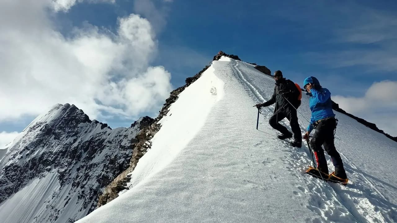
Standing at 6,250 m (20,505 ft), Kang Yatse II is widely regarded as one of the finest introductory 6,000-meter peaks in the Indian Himalayas. Less technical than neighboring Kang Yatse I, it provides ambitious trekkers with their first experience of expedition climbing while remaining accessible with basic snow and glacier skills. The approach follows the legendary Markha Valley through Hemis National Park, passing remote Ladakhi villages, Buddhist monasteries, yak pastures, and the magnificent Nimaling plateau before reaching the high camps beneath the mountain. Summit day combines steep scree, snow slopes, glacier travel, and an exposed final ridge rewarded by sweeping views across the Zanskar Range, Karakoram, Stok Kangri region, and the Indus Valley. For many mountaineers, Kang Yatse II serves as the gateway to Himalayan climbing beyond traditional trekking.
Ready to book? Compare verified operators for Kang Yatse 2 Peak Expedition — transparent pricing, no paid rankings.
Quick Facts
Duration
Max Altitude
Difficulty
Best Time
Trek Distance
Trail Atmosphere
Stargazing
Class 1 Dark Sky
Scent Profile
Silence Level
~10 dB
Vertigo Factor
8 / 10
Primarily a joint & muscle impact and cumulative fatigue challenge
A demanding expedition with extreme joint & muscle impact, cumulative fatigue, and altitude exposure. This route will push every dimension of your physical and mental endurance to the limit.
Iconic Spots
Yunam Summit (20,046 ft)
Getting There
Route to Base
Fly to Leh (IXL)
Drive ~2hrs to Chilling, then 4–5 day trek through Markha Valley to Base Camp
Base Village
Nimaling
15,420 ft
Nearest Railhead
Jammu Tawi (~600km)
Nearest Airport
Kushok Bakula Rimpochhe Airport, Leh (IXL)
Last ATM
Leh
Nearest Medical Facility
SNM Hospital, Leh (~50km from Nimaling by horse + vehicle)
Mobile Signal
None.
Water Sources
Snow melting required at Base Camp.
Charging
Zero charging points after Keylong.
For Drivers
Road Condition
Manali to Darcha is excellent highway. Darcha to Bharatpur is steep, unpaved highway traversing sheer cliffs.
Keylong / Jispa
Trail Culinary & Diet
Don't miss the High altitude noodle soups for fast carb absorption
Buy specialized diet items at Manali
The Content & Remote Hub
No DronesStrictly banned due to extreme high altitude and proxy to military checkposts.Top Vlog Spots
Video Calls
none
Est. 0 Mbps
UPI Reliability
1/10
Guide Wisdom
Caution
Keep your water bottles inside your jacket on summit night. At -15°C they will freeze in your pack's side pocket within an hour.
Explore In Detail
Day by Day Itinerary
11-day route reaching 20,505ft. Covers 90km of varied terrain.
→ See full itinerary with altitude profileDifficulty & Fitness
Rated challenging. High-altitude snowfield approach with gentle scree in the lower sections.
→ See difficulty breakdown and fitness guideCost & Pricing
Packages range from ₹36,000 – ₹61,000. Inclusions and hidden costs vary by operator tier.
→ See full cost breakdownPermits and Regulations
IMF Peak Royalty fee required. Hemis National Park Entry fee applicable. All managed by operator.
Learn more about how we vet operators and ensure transparency on our why MountRoutes page.
Packing List
Expedition Clothing
- Summit Down Jacket (-25°C rating mandatory)
- Waterproof breathable alpine trousers
- Heavyweight thermal baselayers (Upper & Lower)
- Fleece mid-layers
- Balaclava/Face mask (To prevent frostbite from summit winds)
Footwear & Navigation
- Category C or D Expedition Boots (Must be extremely stiff-soled)
- Gaiters (For walking through the deep snow on the upper ridges)
- Micro-spikes (Operator usually provides crampons if ice is hard)
Wilderness Survival Gear
- Category 4 Glacier glasses (Mandatory)
- Trekking poles with snow baskets
- Heavy-duty expedition mitts (Not just gloves)
Flora & Fauna
Flora
Fauna
Local Ladakhi shepherds believe Kang Yatse is protected by mountain deities — the Markha Valley communities make offerings before each climbing season.
— Local folklore
Spiritual & Cultural Significance
Low. Purely a mountaineering challenge.
🕐 Shrine Timings: N/A
Temple Protocols
Frequently Asked Questions
Do I need prior mountaineering experience for Kang Yatse II?
You do not need formal mountaineering courses. KY2 is classified as a non-technical PD-grade peak, which is a steep snow hike. However, prior experience with high-altitude treks above 15,000 ft (like Roopkund, Pin Bhabha, or Goechala) is strongly recommended.
How different is KY2 from KY1?
KY2 (6,240m) is a non-technical walk-up requiring basic crampon walking on a 30-35° snow slope. KY1 (6,400m) is a highly technical AD+/D- climb requiring technical glacier travel, bergschrund navigation, fixed ropes, and traversing a heavily exposed knife-edge summit ridge.
What is the best month to climb Kang Yatse II?
The ideal window is between July and September. During these months, the Markha Valley is protected from the monsoon by the Trans-Himalayan rain shadow. July offers beautiful snow slopes, while August and September expose more scree but provide firmer, consolidated snow.
What is the summit day difficulty and slope gradient?
The summit climb is physically punishing but technically straightforward. The average slope gradient is around 30° to 35° snow and scree. Altitude is the main obstacle, making every step above 6,000 meters incredibly exhausting.
Is it necessary to spend 2 days in Leh before the expedition?
Absolutely mandatory. Flying directly to Leh (3,500m / 11,500ft) is a massive altitude shock to the body. You must spend the first 2-3 days resting and doing light walks in Leh to acclimatize and prevent acute mountain sickness (AMS).
Is Diamox recommended for the climb?
Many climbers use prophylactic Diamox (Acetazolamide) to aid acclimatization. A slow-ascent itinerary combined with proper hydration is the primary defense, but Diamox can be highly useful. Always consult your physician before starting the dosage.
How cold does it get at Base Camp and during the summit bid?
Night temperatures at Base Camp (5,000m) range from -5°C to -10°C. During the summit push, wind chill can drive temperatures down to -15°C or lower. Double mountaineering boots, a -20°C sleeping bag, and a heavy-duty down parka are essential.
What gear is required for the climb?
While non-technical, you must wear specialized mountaineering boots (semi-rigid or rigid B2/B3 boots), 12-point steel crampons, an ice axe (for balance and self-arrest), a climbing harness, helmet, and safety sling.
What is the source of water on the trail and at camps?
Natural glacial stream water is boiled or chemically treated at Base Camp and lower camps. During the summit push, climbers melt snow at the high camp flats. It is helpful to carry personal chlorine dioxide water purification tablets.
Are there mobile networks or charging points available?
There is zero mobile coverage after leaving Skiu. The last network reception is in Leh and Chilling. There are no charging facilities; climbers must bring high-capacity power banks (at least 20,000 mAh) and keep them warm to retain charge.
Is helicopter evacuation feasible for KY2?
Yes, the Nimaling pasture and Base Camp are flat enough for helicopter landing, subject to military approval and favorable weather. However, a comprehensive medical insurance policy covering high-altitude helicopter rescue is mandatory.
How are baggages and loads transported to Base Camp?
Pack mules and horses transport all group equipment, kitchen supplies, and climbers' main duffel bags up to KY2 Base Camp. Climbers only need to carry a standard daypack (approx. 5-7 kg) containing hydration, rain gear, and personal medication.
Other Expeditions Guides
Still deciding?
Compare routes side-by-side to find the perfect match for your fitness, dates, and budget.
Everything you need to know, in one place. Someone else in your group needs to see this.
Planning Kang Yatse 2 Peak Expedition?
Get route conditions, operator updates, and season windows before booking.
No spam. Only useful updates.
Ready to walk this route?
You’ve read the guide, now find the perfect local team to take you there. Compare our verified list of operators.
Compare verified operators