Essential Planning Guide
Bara Shigri Glacier Traverse Expedition — Complete Guide (2026)
Introduction
Bara-Shigri is the largest glacier in Himachal Pradesh and the second largest in the Indian Himalayas (after Siachen). Stretching 25 km in length and feeding the Chandra River, this massive ice body is the hydrological lifeline of the Lahaul Valley. The trek from Batal takes you to the glacier's snout and, for advanced groups, up the lateral moraine to the upper ice field. Walking on Bara-Shigri is walking on living geological history — the ice is thousands of years old, shaped by forces that predate human civilization. The glacier is also a critical climate research site — its recession rate is one of the key indicators of Himalayan climate change, monitored by the Geological Survey of India and WIHG (Wadia Institute of Himalayan Geology). For adventure trekkers, it is one of the few places where you can walk on a major Himalayan glacier without mountaineering equipment.
Ready to book? Compare verified operators for Bara Shigri Glacier Traverse Expedition — transparent pricing, no paid rankings.
Quick Facts
Duration
Max Altitude
Difficulty
Best Time
Trek Distance
Trail Atmosphere
Stargazing
Class 1 Dark Sky
Scent Profile
Silence Level
~20 dB
Vertigo Factor
3 / 10
Primarily a altitude exposure and cumulative fatigue challenge
A demanding expedition dominated by extreme altitude exposure.
Iconic Spots
Glacier Tongue
Lateral Moraine Ridge
Getting There
Route to Base
5 hours from Manali via Atal Tunnel
Base Village
Batal (via Manali)
Nearest Railhead
Rishikesh
Nearest Airport
Jollygrant Airport
Last ATM
Manali.
Nearest Medical Facility
Keylong District Hospital
Mobile Signal
Zero signal at the glacier and the approach from Batal. BSNL intermittent at Kunzum Top (20km away).
Water Sources
Glacial melt streams (highly silty; requires filter/alum). Clear springs found occasionally on high lateral moraine banks. Carry 5L for glacier crossing.
Charging
No electricity beyond Batal roadhead (Generator-only at Dhabas). Extreme remote exploration zone.
For Drivers
Road Condition
Rough off-roading from Atal Tunnel to Batal; Stream crossings common on road.
Manali / Kaza
Trail Culinary & Diet
Don't miss the Thukpa / Chura (Dried Cheese)
Buy specialized diet items at Manali Town
The Content & Remote Hub
Top Vlog Spots
Video Calls
none
Est. 0 Mbps
UPI Reliability
1/10
The Living Archive
Key point
Bara-Shigri is not just a glacier — it's a 25 km archive of climate history. The moraine layers tell the story of thousands of years of ice advance and retreat.
Key point
Standing at the snout, watching meltwater gush out as the Chandra River, you are witnessing the birth of one of the great Himalayan rivers.
Explore In Detail
Day by Day Itinerary
8-day route reaching 16,503ft. Covers 40km of varied terrain.
→ See full itinerary with altitude profileDifficulty & Fitness
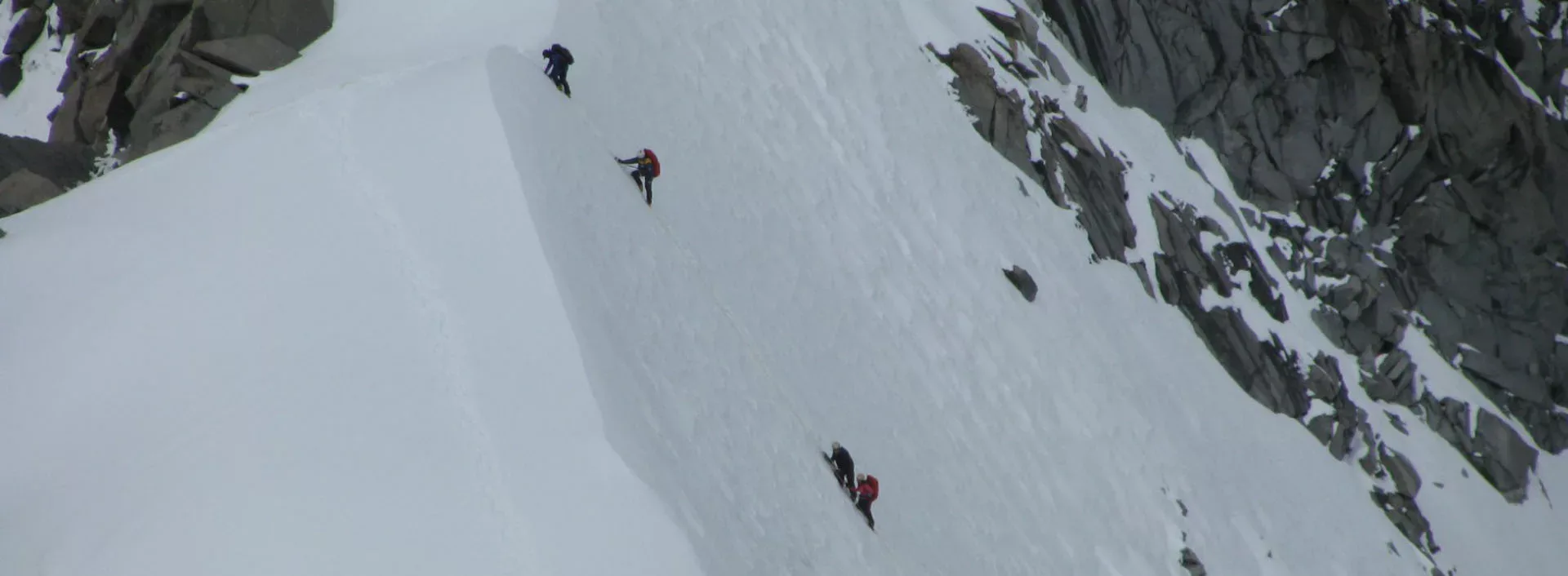
Rated challenging. Glacial moraine (loose rock ridges) and glacier surface. No technical climbing but extreme care needed near crevasses.
→ See difficulty breakdown and fitness guideCost & Pricing
Packages range from ₹20,000 – ₹35,000. Inclusions and hidden costs vary by operator tier.
→ See full cost breakdownPermits and Regulations
The glacier falls within the Lahaul-Spiti district. No formal trekking permit is currently required for the snout approach, but groups going onto the glacier body need registration with the Keylong Forest Division. The glacier is a research site — respect any GSI/WIHG markers or camps. Waste management is critical in this pristine glacial environment. ITBP patrols the upper valley — carry photo ID.
Learn more about how we vet operators and ensure transparency on our why MountRoutes page.
Flora & Fauna
Flora
Fauna
The largest glacier in Himachal Pradesh. Means 'Great Glacier' in Lahauli dialect. Legend says it is a living entity that 'breathes' and 'moves'; historically famous for blocking the Chandra river in 1936, creating a temporary lake.
— Local folklore
Spiritual & Cultural Significance
Revered by Lahauli people as a source of water and life-giving rivers.
🕐 Shrine Timings: N/A
Temple Protocols
Frequently Asked Questions
What does "Bara Shigri" mean?
In the local Spiti dialect, it means "Great Glacier". It is the largest glacier in Himachal Pradesh.
Is walking on the glacier dangerous?
Yes, the surface is a mix of rock (moraine) and hard ice. Hidden crevasses and unstable rock-over-ice slopes make it a high-risk trek without a professional guide.
Do I need crampons?
For specific blue-ice sections and crossing the snout, microspikes or crampons are highly recommended for safety.
Who is "Lady of Keylong"?
It is a natural rock/snow formation on one of the surrounding peaks that resembles a lady walking, visible from the glacier.
Is there mobile signal at Batal?
Batal is the base; it has zero mobile signal. The only connectivity is the public satellite phone at the Chandra Dhabha.
Can we see the Chandra river source?
Yes, the Chandra river is born from the melting waters of the Bara Shigri glacier snout.
How cold it gets on the glacier?
Even in summer, night temperatures on the glacier camps can drop to -10°C to -15°C.
What is the total duration?
Typically 8-10 days, depending on whether you reach the Concordia point or just explore the snout.
Other Expeditions Guides
Still deciding?
Compare routes side-by-side to find the perfect match for your fitness, dates, and budget.
Everything you need to know, in one place. Someone else in your group needs to see this.
Planning Bara Shigri Glacier Traverse Expedition?
Get route conditions, operator updates, and season windows before booking.
No spam. Only useful updates.
Ready to walk this route?
You’ve read the guide, now find the perfect local team to take you there. Compare our verified list of operators.
Compare verified operators