Essential Planning Guide
Surajtal Lake Trek — Complete Guide (2026)
Introduction
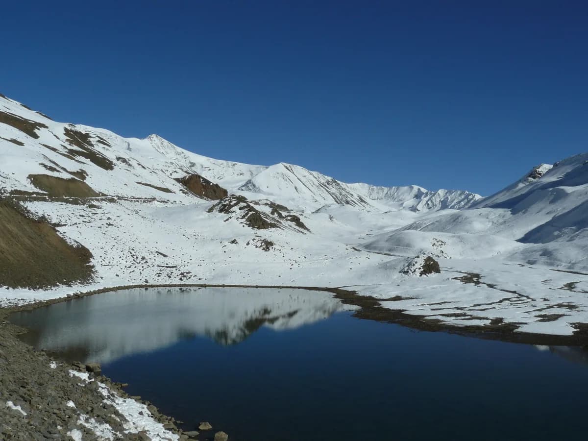
Suraj Tal, the ''Lake of the Sun God'', is a turquoise jewel set in the crown of the Baralacha La pass. At 15,800 ft, it is one of the highest lakes in India and a primary source of the Bhaga River. While many travelers view it from the Manali-Leh highway, the Surajtal Lake Trek is a deliberate, high-altitude approach designed for serious mountaineers and those looking to acclimatize for 6,000m peaks. The landscape is quintessential Lahaul—stark, desert-like, and dominated by massive scree-covered peaks and hanging glaciers. Walking to Surajtal from the lower camps at Patseo involves navigating high-altitude desert plateaus where the air is thin, the sun is harsh, and the water is an impossibly deep shade of blue.
Ready to book? Compare verified operators for Surajtal Lake Trek — transparent pricing, no paid rankings.
Quick Facts
Duration
Max Altitude
Difficulty
Best Time
Trek Distance
Trail Atmosphere
Stargazing
Class 1 Dark Sky
Scent Profile
Silence Level
~25 dB
Vertigo Factor
2 / 10
Primarily a altitude exposure and cardio demand challenge
A demanding expedition that balances altitude exposure and cardio demand.
Iconic Spots
Emerald Turquoise
Baralacha La Vistas
Getting There
Route to Base
Drive from Manali via Atal Tunnel (Keylong) and then toward Leh highway
Base Village
Keylong / Darcha
10,500 ft
Last ATM
Keylong Town.
Nearest Medical Facility
Army Medical Post at Patseo (Very limited) or Keylong Civil Hospital.
Mobile Signal
BSNL at Darcha. Total silence at Patseo, Zingzingbar, and Surajtal.
Water Sources
Bhaga river flows along the lower sections. Glacial melt streams near the lake shore. Carry purification as BRO camps are upstream.
Charging
Zero electricity beyond Darcha. Solar chargers perform exceptionally well in this dry, high-UV environment.
For Drivers
Road Condition
NH-3 is excellent highway but prone to major snow blocks at Baralacha La early in the season.
Tandi (Refill is mandatory here)
Trail Culinary & Diet
Don't miss the Thugpa and Siddu
Buy specialized diet items at Keylong
The Content & Remote Hub
Top Vlog Spots
Video Calls
none
Est. 0 Mbps
UPI Reliability
1/10
The Bhaga Source
Key point
The lake is the starting point of the Bhaga river, which later joins the Chandra river at Tandi to form the mighty Chenab.
Explore In Detail
Day by Day Itinerary
4-day route reaching 16,040ft. Covers 28km of varied terrain.
→ See full itinerary with altitude profileDifficulty & Fitness
Rated challenging. Mostly high-altitude desert terrain with loose gravel and sharp stones. The final approach to the lake involves some boulder hopping.
→ See difficulty breakdown and fitness guideCost & Pricing
Packages range from ₹5,600 - ₹16,000. Inclusions and hidden costs vary by operator tier.
→ See full cost breakdownPermits and Regulations
No formal permits required for Indian citizens. Foreigners must possess a valid Inner Line Permit (ILP) and register at the army check-posts in Patseo or Zingzingbar. Camping is restricted near the lake shore to protect the fragile ecosystem.
Learn more about how we vet operators and ensure transparency on our why MountRoutes page.
Packing List
High-Altitude Essentials
- Down jacket (rated to -10°C even in summer)
- Category 4 high-altitude sunglasses (mandatory for snow glare)
- Broad-spectrum sunscreen (SPF 50+)
- Lip balm with UV protection
- Heavy-duty windbreaker shell
Gear
- Sturdy waterproof trekking shoes with ankle support
- Insulated water bottle (prevents freezing)
- Trekking poles for moraine sections
- Emergency whistle and headlamp
Flora & Fauna
Flora
Fauna
Legend says the Sun God (Surya) created the lake as his abode. A romantic elopement between the Sun God''s son (Bhaga) and the Moon God''s daughter (Chandra) gave birth to the two rivers.
— Local folklore
Spiritual & Cultural Significance
Abode of Lord Surya. Taking a dip is believed to cleanse sins.
🕐 Shrine Timings: Open access (No formal temple building)
Temple Protocols
- •Maintenance of quiet
- •No littering in sacred water
Festivals & Dates
Frequently Asked Questions
Is the lake frozen in summer?
Suraj Tal remains partially frozen well into June. By July and August, it turns a brilliant emerald-turquoise. It starts freezing again by late September.
Can I do this without a guide?
Since the trail is close to the highway, navigation is relatively easy, but the extreme altitude (≈16,000 ft) makes it dangerous for solo trekkers without support in case of AMS.
Other Treks Guides
Still deciding?
Compare routes side-by-side to find the perfect match for your fitness, dates, and budget.
Everything you need to know, in one place. Someone else in your group needs to see this.
Planning Surajtal Lake Trek?
Get route conditions, operator updates, and season windows before booking.
No spam. Only useful updates.
Ready to walk this route?
You’ve read the guide, now find the perfect local team to take you there. Compare our verified list of operators.
Compare verified operators