
Explore
Intelligence
Essential Planning Guide
Pin Bhabha Pass Trek — Complete Guide (2026)
Vibe & Scenery
The Experience
Introduction
The Pin Bhabha Pass Trek is renowned for the remarkable contrast it offers between two distinct Himalayan landscapes. Beginning in the forested Bhabha Valley of Kinnaur, the trail passes through alpine meadows, river valleys, and glacial terrain before crossing Pin Bhabha Pass at approximately 16,100 ft.
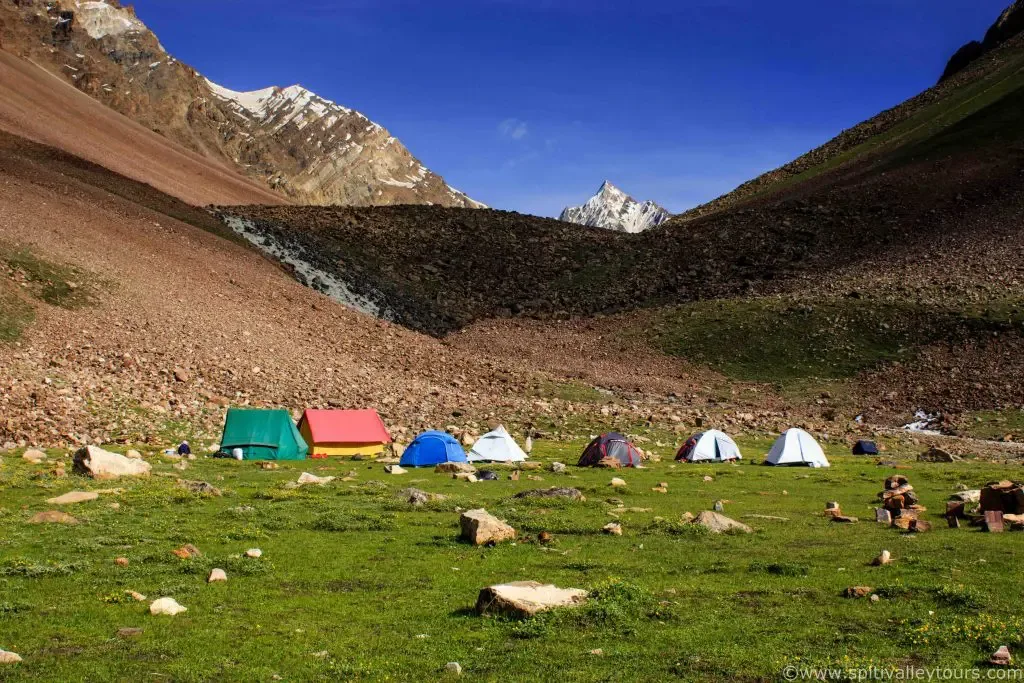
Beyond the pass, the scenery changes dramatically as trekkers descend into the barren mountains and wide valleys of Pin Valley National Park in Spiti. Along the way, the route combines forests, high-altitude meadows, moraines, and panoramic mountain views, making it one of India's most visually diverse trekking experiences.
Because of its sustained altitude, demanding pass crossing, and long trekking days, Pin Bhabha Pass is best suited to experienced trekkers with good fitness and prior Himalayan experience.
Quick Facts
Duration
Max Altitude
Difficulty
Best Time
Trek Distance
Trail Atmosphere
Stargazing
Class 1 Dark Sky
Scent Profile
Silence Level
~25 dB
Vertigo Factor
6 / 10
Iconic Spots
Mulling Meadows
Pin Bhabha Top
Environment
Nature & Culture
Flora & Fauna
Flora
Fauna
The pass is a holy gateway between the Hindu deities of Kinnaur and the Buddhist protector spirits of Spiti.
— Local folklore
Spiritual & Cultural Significance
Crossing the pass takes you from a Hindu-dominant region to a deeply Tibetan-Buddhist region.
🕐 Shrine Timings: N/A
Temple Protocols
Technical Details
Challenge & Preparation
Primarily a cardio demand challenge
A capable trekker's route dominated by extreme cardio demand.
Personal Readiness
Am I ready?
Planning
Logistics & Trail Intel
Getting There
Route to Base
Bus from Shimla to Rampur, then another bus/taxi to Kafnu
Base Village
Kafnu
7,800 ft
Last ATM
Rampur Bushahr
Nearest Medical Facility
Bhabhanagar Hospital
Mobile Signal
Drops dead at Kafnu. Returns near Kaza.
Water Sources
Abundant streams in Kinnaur. Highly scarce while descending into Spiti.
Charging
Zero charging points after Kafnu until Kaza.
For Drivers
Road Condition
Shimla to Rampur is smooth highway. The cut off to Kafnu is rough and prone to landslides.
Rampur
Trail Culinary & Diet
Don't miss the Thukpa (in Spiti)
Buy specialized diet items at Shimla
The Content & Remote Hub
No DronesDrones are prohibited in the Kinnaur/Spiti border wildlife zones.Top Vlog Spots
Video Calls
none
Est. 0 Mbps
UPI Reliability
3/10
Permits and Regulations
Forest permits required from the Kafnu Forest Department. For foreigners, an Inner Line Permit might be checked if descending deep into border zones of Kinnaur/Spiti.
Learn more about how we vet operators and ensure transparency on our why MountRoutes page.
Packing List
High-Altitude Clothing
- Heavy down jacket (-10°C to -15°C rating)
- Waterproof breathable alpine trousers
- Multiple thermal baselayers
- Fleece mid-layers
Footwear & Navigation
- High-ankle waterproof trekking boots with stiff climbing soles
- Micro-spikes (Mandatory for the pass crossing)
- Gaiters (For walking through the deep snow on the pass)
Wilderness Survival Gear
- Category 4 Glacier glasses (The sun reflection in Spiti will cause snow blindness)
- Trekking poles with snow baskets
- Personal medical kit with AMS medication
Deep Dives
Explore Further
Editor's Notes
Cross the river at Kara before 9 AM. By noon, the glacial melt turns the knee-deep stream into a raging, waist-deep torrent that will knock you over.
Explore In Detail
Day by Day Itinerary
8-day route reaching 16,100ft. Covers 50km of varied terrain.
→ See full itinerary with altitude profileDifficulty & Fitness
Rated moderate. The pass crossing involves a near 60-degree ascent on loose rock and snow.
→ See difficulty breakdown and fitness guideCost & Pricing
Packages range from ₹16,000 to ₹22,000. Inclusions and hidden costs vary by operator tier.
→ See full cost breakdownFrequently Asked Questions
How does Pin Bhabha compare to Pin Parvati Pass?
Pin Bhabha is significantly safer. Pin Parvati requires crossing heavily crevassed active glaciers and navigating deadly river pulleys. Pin Bhabha has steep snow/scree but no major crevassed glacier crossings.
Is this trek suitable for beginners?
Absolutely not. The altitude hits 16,100 ft. You are subjected to freezing temperatures, thin air, and massive 10+ hour walking days. Prior high-altitude experience (13,000+ ft) is mandatory.
Why do the landscapes suddenly change?
The pass acts as a massive rain shadow wall. The monsoon winds dump all their rain on the Kinnaur side, keeping it green. The Spiti side receives zero rain, making it a high-altitude desert.
Can I do this trek without a guide?
Not recommended. Finding the exact saddle point over the pass in whiteout conditions is extremely difficult. Furthermore, a massive logistical support team is needed to haul food over the pass.
Is there phone network on the trek?
No. You will lose network completely at Kafnu (Day 1) and will not get it back until you reach Kaza in Spiti at the very end of the trek.
What is the AMS risk?
High. The altitude gain is rapid as you approach the pass. Strict acclimatization protocols and drinking 4-5 liters of water daily are non-negotiable.
Are there any river crossings?
Yes. On the Kinnaur side, you must cross tributaries of the Bhabha river. In early summer, the water is freezing, fast, and waist-deep. Guides usually use ropes.
What if someone gets sick near the pass?
If AMS sets in before the pass, the trekker must be immediately evacuated back down to Kafnu via mules. If it happens on or after the pass, evacuation is towards Mudh village in Spiti.
Do I need to carry oxygen?
Commercial operators will always carry a portable oxygen cylinder. If trekking privately, it is highly advised to carry at least two portable cans per person.
How cold does it get at night?
At the advanced base camps (Pushtirang/Phutsirang), temperatures routinely drop to -5°C to -10°C even in summer. High wind chill makes it feel significantly colder.
Route Intelligence
Routes With Similar Character
Routes that share the character of Pin Bhabha Pass Trek.
Rupin-Supin River Trail Trek
Trekkers frequently compare these. Both routes are defined by crossing a major Himalayan pass, involving major terrain transitions.
Hampta Pass Trek
Trekkers frequently compare these. Both routes are defined by crossing a major Himalayan pass, involving major terrain transitions.
Buran Ghati Trek
Both routes are defined by crossing a major Himalayan pass, involving major terrain transitions. They share multiple characteristics.
Still deciding?
Compare routes side-by-side to find the perfect match for your fitness, dates, and budget.
Everything you need to know, in one place. Someone else in your group needs to see this.
Planning Pin Bhabha Pass Trek?
Get route conditions, operator updates, and season windows before booking.
Don't miss out! Follow us for route updates@mountroutes|LinkedIn
No spam. Only useful trek updates.
Ready to walk this route?
You’ve read the guide, now find the perfect local team to take you there. Compare our verified list of operators.
Compare verified operators