Explore
Intelligence
Detailed Route
Pin Bhabha Pass Trek Itinerary — Day by Day Route & Camps
A 8-day immersive expedition traversing diverse Himalayan landscapes and alpine altitudes.
Standard RouteThis is the standard mountain pacing for this trek. Specific operators may add an acclimatization day or alter the starting point. Check individual operator schedules for their exact logistics.
Duration
8 Days
Total Distance
50 KM
Max Altitude
16,100 FT
Trek Type
linear
Permits Required Before You Go
Permit Cost
Where to Get
Forest office in Kafnu or Bhabhanagar
Documents
Aadhar Card / Passport, Medical Fitness Certificate
Foreign Nationals
Foreigners MUST carry an Inner Line Permit if navigating via the Kinnaur border region from Shimla.
Foreigner Process
Inner line permit requires applying in Shimla or Rekong Peo with a registered operator.
Nearest Embassy Hub
New Delhi
Day by Day Breakdown
Camp Alt
7,800 ft
Day Gain
+1,000 ft
Drive Shimla to Kafnu
Drive deep into the Kinnaur gorge along the roaring Sutlej river.
Key Landmarks
Staying At
The drive navigates deep into the sheer rock walls of the Sutlej gorge, transitioning into the forested Kinnaur region.
Camp Alt
10,600 ft
Day Gain
+2,800 ft
Reach Mulling
A massive, steady ascent climbing out of the valley floor into the endless, incredibly lush green meadows of Mulling.
Key Landmarks
Staying At
The trail leaves the Kafnu settlement and enters thick, damp pine and oak forests, eventually breaking out into a broad alpine meadow.
Field Notes
KEY ACTIONRiver Crossings
Plan to cross early in the day before snowmelt swells the water levels. Unclip backpack waist belts before crossing.
Camp Alt
11,800 ft
Day Gain
+1,200 ft
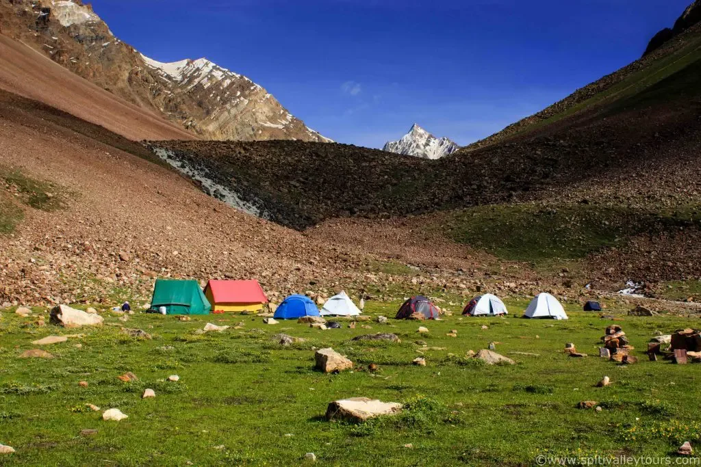
Reach Kara
A shorter acclimatization day. Involves crossing a freezing stream. The campsite at Kara is stunningly set by a high alpine lake.
Key Landmarks
Staying At
The meadow opens into a higher alpine basin characterized by glacial streams, wildflowers and a high alpine lake at Kara.
Camp Alt
13,500 ft
Day Gain
+1,700 ft
Reach Pushtirang
Move to the advanced base camp right below the pass. The greenery begins to entirely strip away, replaced by grey rock and ice.
Key Landmarks
Staying At
Tree line disappears as the valley broadens into a spectacular high-altitude alpine meadow basin, replacing the dense forests with expansive grazing pastures.
Field Notes
Use Trekking Poles
Trekking poles are highly recommended to save your knees on the descent.
INFOSlower Progress
Progress will be significantly slower and more taxing on your ankles than trail distance suggests.
Camp Alt
13,600 ft
Day Gain
+100 ft
Today's Objective
🏔 Cross Cross Pin Bhabha Pass
Summit day. Start at 3 AM. Climb a brutal, steep 3,000 ft up snow and scree. Stand on the pass and look into the arid, pink mountains of Spiti. Descend relentlessly.
Key Landmarks
Staying At
Crossing the high-altitude pass bridges two distinct watershed systems, shifting the expedition over the glaciated divide and down into a new river basin.
Field Notes
Use Trekking Poles
Trekking poles are highly recommended to save your knees on the descent.
INFOSlower Progress
Progress will be significantly slower and more taxing on your ankles than trail distance suggests.
Camp Alt
12,500 ft
Day Gain
-1,100 ft
Reach Mudh Village
A massive, long horizontal walk across the floor of the Pin Valley. The landscape is entirely devoid of trees. Reach the ancient Spitian village of Mudh.
Key Landmarks
Staying At
Crossing the high-altitude pass bridges two distinct watershed systems, shifting the expedition over the glaciated divide and down into a new river basin.
Camp Alt
12,500 ft
Day Gain
0 ft
Drive Mudh to Kaza
Short drive to the civilized hub of Kaza. Rest day.
Key Landmarks
Staying At
The motorable road navigates deeper into the mountain river corridor, where the landscape transitions from lower foothills into the steep, dense forested valleys.
Camp Alt
6,700 ft
Day Gain
-5,800 ft
Drive Kaza to Manali (via Rohtang)
Brutal, long drive back out of Spiti crossing two more high passes to reach Manali.
Key Landmarks
The vehicle route exits the barren Spiti desert over two major passes, dropping dramatically back into the lush, green alpine forests of the Kullu Valley.
Trek Extensions & Add-ons
Spiti Valley Road Trip
+4 DaysAfter reaching Kaza, hire a jeep and explore Key Monastery, Chicham Bridge, and Hikkim (Highest post office).
Plan Your Trek:
Ready to book? Compare verified operators for Pin Bhabha Pass Trek — transparent pricing, no paid rankings.
Still deciding?
Compare routes side-by-side to find the perfect match for your fitness, dates, and budget.
Day by day, camp by camp. Send this to your group so everyone's on the same page.
Step 4: Cost & Logistics
You understand the route.
Now see what services, permits, and logistics actually cost.
View Cost Breakdown