Essential Planning Guide
Phulara Ridge Trek — Complete Guide (2026)
Introduction
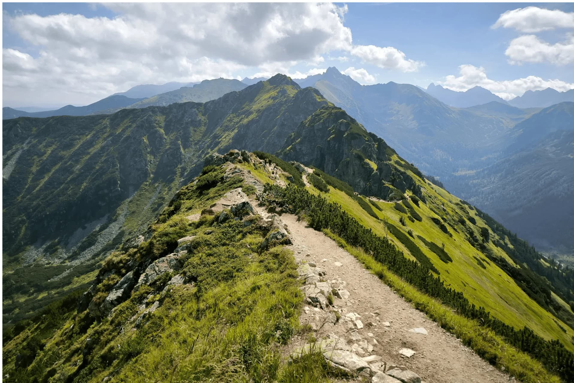
Phulara Ridge is the 'Trending Queen' of the Garhwal Himalayas and for good reason. While most treks lead you to a single summit point, Phulara offers a rare, 4-hour continuous walk along a narrow alpine crest at 12,000 ft. This 'Infinity Walk' provides a 360-degree theater of the giants, featuring the Swargarohini massif, Bandarpoonch, and the formidable Black Peak (Kalanag) flanking you on both sides. Unlike the crowded trails of its neighbor, Kedarkantha, Phulara remains a pristine sanctuary of ancient birch forests (Bhojpatra) and the vast, undulating 'Fairyland' meadows of Pushtara. It is the perfect trek for those who find peace in high-altitude exposure and long, panoramic horizons.
Ready to book? Compare verified operators for Phulara Ridge Trek — transparent pricing, no paid rankings.
Quick Facts
Duration
Max Altitude
Difficulty
Best Time
Trek Distance
Trail Atmosphere
Stargazing
Class 1 Dark Sky
Scent Profile
Silence Level
~25 dB
Vertigo Factor
3 / 10
Primarily a joint & muscle impact and altitude exposure challenge
A capable trekker's route that balances joint & muscle impact and altitude exposure.
Iconic Spots
Phulara Ridge Line
Pushtara Meadow
Getting There
Route to Base
10-hour drive from Dehradun
Shared taxis at Dehradun Rly Station peak at 6:30 AM
Base Village
Sankri
6,400 ft
Nearest Railhead
Rishikesh
Nearest Airport
Jollygrant Airport
Last ATM
Purola (Not 100% reliable). Withhold cash in Dehradun.
Nearest Medical Facility
Mori PHC (22 km) / Uttarkashi District Hospital
Mobile Signal
Strong 4G at Sankri. Patchy BSNL/Jio at Pushtara (high meadow). Zero coverage on the actual 4-hour ridge walk stretch.
Water Sources
Supin river tributaries at lower levels. Reliable springs at Puani Garaat and Bhoj Gadi. The entire ridge section is dry; carry 3L minimum.
Charging
Final reliable charging at Sankri lodges. Zero availability throughout the ridge camps (Bhoj Gadi/Pushtara).
For Drivers
Road Condition
Dehradun to Sankri road is mostly good; final 20km stretch is winding and narrow village road.
Purola
Trail Culinary & Diet
Don't miss the Sankri Apple Pie / Garhwali Stew
Buy specialized diet items at Dehradun / Mussoorie
The Content & Remote Hub
Top Vlog Spots
Video Calls
base-only
Est. 15 Mbps
UPI Reliability
5/10
Base WiFi Available
The Infinity View
Key point
Phulara Ridge is the only trek where the peaks don't 'hide' behind the ridge; they are literally your wall throughout the walk.
Key point
From the ridge, you can trace the mythical 'Path to Heaven' taken by the Pandavas.
Explore In Detail
Day by Day Itinerary
6-day route reaching 12,127ft. Covers 29km of varied terrain.
→ See full itinerary with altitude profileDifficulty & Fitness
Rated moderate. Consistent forest trail for Day 2-3. Day 4 is a ridge walk on hard-packed soil and grass. Day 5 is a long descent on rocky forest paths.
→ See difficulty breakdown and fitness guideCost & Pricing
Packages range from ₹9,500 – ₹16,500. Inclusions and hidden costs vary by operator tier.
→ See full cost breakdownPermits and Regulations
The trek is located within the Govind Wildlife Sanctuary and National Park. Entry permits are mandatory and are issued at the Netwar Forest Gate. Indian nationals require a photo ID and a medical certificate (standard for the region). Foreigners must provide passport/visa copies. Group sizes are often regulated during peak seasons. Note that the Taluka-Sankri road is prone to landslides, which may occasionally add 4-8km of walking to your itinerary.
Learn more about how we vet operators and ensure transparency on our why MountRoutes page.
Packing List
Winter Clothing
- Light down jacket
- 2 thermal base layers
- 1 fleece mid-layer
- Windproof shell jacket
- Trekking pants
- Woolen socks (2 pairs)
- Light gloves
- Sun hat and sunglasses
Footwear Snow Gear
- Standard trekking shoes with good grip
- Gaiters (if trekking in April/December)
- Camp slippers
Gear Safety
- 2 Trekking poles (Essential for balance on the ridge)
- Headlamp with spare batteries
- Water bottle (2.5L capacity for ridge day)
- Sunscreen SPF 50+
- Personal medical kit
Flora & Fauna
Flora
Fauna
The 'Dragon's Back'. Local shepherds believe the ridge is the spine of a sleeping giant guardian protecting the Tons valley. It is one of the rare sustained ridge-walks in the Indian Himalayas.
— Local folklore
Spiritual & Cultural Significance
Sacred oak groves managed by local village deities (Someshwar Mahadev).
🕐 Shrine Timings: N/A
Temple Protocols
- •Do not litter near sacred trail cairns
Frequently Asked Questions
What is a "Ridge Trek"?
Unlike valley treks, you walk along the thin top-line of a mountain ridge for several kilometers, offering views of valleys on both sides.
How many days do we spend on the ridge?
The main ridge-walk lasts for about 4-5 hours, but you have ridge-side views for at least 2 days of the trek.
Can we see Swargarohini peaks?
Yes, this trek offers an exceptional close-up of the Swargarohini massif and the Kalanag peak.
Is it safe for beginners?
Moderate fitness is needed. The ridge walk has some narrow sections that might feel exposed if you have a fear of heights.
What is the base village?
The trek typically starts from Sankri, the same base as Har Ki Dun and Kedarkantha.
Are there any steep descents?
The descent from the ridge towards the Pushtara meadows is a long, continuous walk that can be hard on the knees; trekking poles are recommended.
Other Treks Guides
Still deciding?
Compare routes side-by-side to find the perfect match for your fitness, dates, and budget.
Everything you need to know, in one place. Someone else in your group needs to see this.
Planning Phulara Ridge Trek?
Get route conditions, operator updates, and season windows before booking.
No spam. Only useful updates.
Ready to walk this route?
You’ve read the guide, now find the perfect local team to take you there. Compare our verified list of operators.
Compare verified operators