Detailed Route
Phulara Ridge Trek Itinerary — Day by Day Route & Camps
Standard RouteThis is the standard mountain pacing for this trek. Specific operators may add an acclimatization day or alter the starting point. Check individual operator schedules for their exact logistics.
Duration
6 Days
Total Distance
29 KM
Max Altitude
12,127 FT
Trek Type
linear
Day by Day Breakdown
Drive: Dehradun to Sankri
Pick up at 7:30 AM. Guesthouse stay in Sankri. Use the evening to rent trekking poles/shoes in the market. Technical: A long, winding mountain drive. The Mori-Netwar section is prone to small rockfalls during rains. Stay alert near the river bents. Hydration is key to avoiding travel-induced altitude sickness. Safety: Ensure you have physical copies of your medical certificate and Aadhar Card for the Netwar checkpost entry.
Key Landmarks
Trek: Sankri to Sikolta
First night in tents. Sikolta is a pristine forest clearing. Sunset through the pine needles is a highlight. Technical: Gradual but consistent uphill on forest trails. Terrain is mostly soft soil and leaf-litter. Excellent grip for standard trekking shoes. Moderate pace recommended. Safety: Watch for loose boulders near the 'Broken Bridge' section. Cross one at a time.
Key Landmarks
Staying At
Trek: Sikolta to Bhoj Gadi
Bhoj Gadi is a massive meadow. Best place for group games and acclimatization walks. Technical: Trek moves above the pine zone into the Birch (Bhojpatra) forest. Shorter distance but thinner air. Gradient increases slightly near Bhoj Gadi. Stable terrain. Safety: Bhoj Gadi is exposed. Night winds can be high. Ensure tent pegs are deep and rain-flys are taut.
Key Landmarks
Staying At
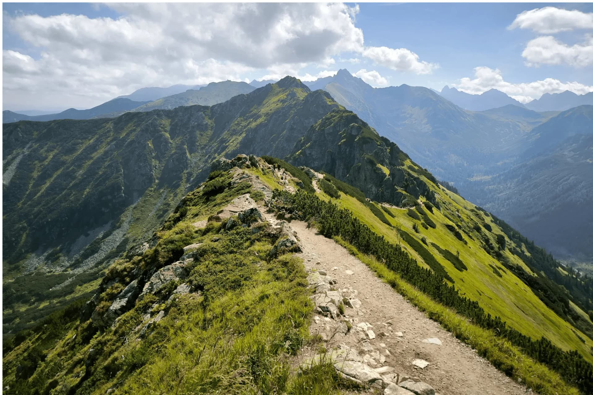
Summit Day: The Infinity Ridge walk to Pushtara
Pushtara is a massive alpine meadow. It's often called the 'Fairyland of Garhwal'. Technical: A 4-5 hour continuous ridge walk. The ridge is narrow with significant drops on either side. Requires focus and balance. Zero water sources on the ridge. Safety: Wind-chill Alert: Even on sunny days, the ridge wind is cutting. Keep high-neck layers ready. UV exposure is extreme; wear polarized glasses.
Key Landmarks
Staying At
Trek: Pushtara to Taluka, Drive to Sankri
Reach Sankri by 4 PM. Celebration night with local 'Sidhwa' dance. Technical: Long persistent descent. Hard on the knees. 100% need for two trekking poles. Terrain re-enters the forest zone. Safety: The Taluka-Sankri road is highly unstable. If there is a blockage, be prepared to trek an extra 4km on the road.
Key Landmarks
Drive: Sankri to Dehradun
Reach Dehradun by 7:00 PM for late night trains/flights.
Trek Extensions & Add-ons
Kedarkantha Crossover
+2 Daystraverse from Pushtara meadow towards Kedarkantha base to combine two legendary treks into one long alpine loop.
Also on this trek
Ready to book? Compare verified operators for Phulara Ridge Trek — transparent pricing, no paid rankings.
Still deciding?
Compare routes side-by-side to find the perfect match for your fitness, dates, and budget.
Day by day, camp by camp. Send this to your group so everyone's on the same page.
Love this itinerary?
Find operators who follow this exact route with verified acclimatization days.
Find matching operators