Explore
Intelligence
Essential Planning Guide
Pangarchulla Peak Trek — Complete Guide (2026)
Vibe & Scenery
The Experience
Introduction
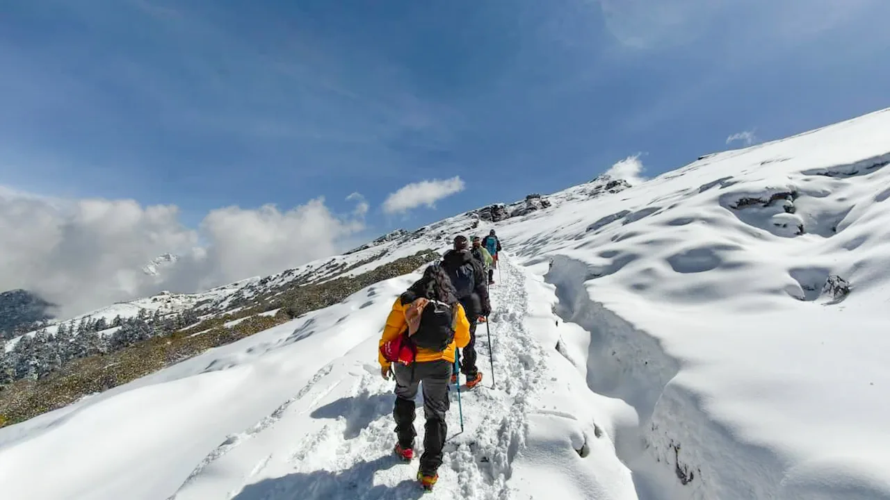
The Pangarchulla Peak Trek combines one of Garhwal's finest summit climbs with the scenic forests and meadows of the Nanda Devi Biosphere Reserve. Starting near Joshimath, the trail passes through oak and rhododendron forests before crossing the expansive slopes of Gorson Bugyal and climbing toward Pangarchulla Peak at approximately 15,069 ft.
The final ascent is considerably steeper than most Himalayan treks and often involves snow-covered slopes during spring, demanding good fitness, careful footing, and, depending on conditions, the use of basic mountaineering equipment under supervision.
From the summit, trekkers are rewarded with panoramic views of Nanda Devi, Dronagiri, Chaukhamba, Hathi-Ghodi, and numerous peaks across the Garhwal Himalayas. It is an excellent objective for experienced trekkers seeking their first Himalayan summit experience.
Quick Facts
Duration
Max Altitude
Difficulty
Best Time
Trek Distance
Trail Atmosphere
Stargazing
Class 1 Dark Sky
Scent Profile
Silence Level
~25 dB
Vertigo Factor
3 / 10
Iconic Spots
The Rock Chimney
Khullara Sunset
Environment
Nature & Culture
Flora & Fauna
Flora
Fauna
The 'Guardian of the Curzon Trail'. Locals believe the peak acts as a spiritual sentry for the Nanda Devi inner sanctuary corridor.
— Local folklore
Spiritual & Cultural Significance
Gateway to the winter seat of Lord Badrinath.
🕐 Shrine Timings: N/A
Temple Protocols
- •Follow silent-trekking rules in sacred forest patches
Technical Details
Challenge & Preparation
Primarily a cardio demand challenge
A capable trekker's route dominated by extreme cardio demand.
Personal Readiness
Am I ready?
Planning
Logistics & Trail Intel
Getting There
Route to Base
10-hour drive from Rishikesh
Shared taxis available near Rishikesh bus stand
Base Village
Joshimath
6,150 ft
Nearest Railhead
Rishikesh
Nearest Airport
Jollygrant Airport
Last ATM
Joshimath town. Reliable. Zero beyond the base town.
Nearest Medical Facility
CHC Joshimath
Mobile Signal
Strong 4G at Dhak/Joshimath. Spotty BSNL signal at Khullara (open meadow). Zero coverage on the final summit ridge.
Water Sources
Permanent springs at Guling and Khullara camp meadows. The summit ridge is entirely dry; carry 3L minimum from Khullara.
Charging
Final reliable charging at Dhak roadhead (village homes). None available on the forest/meadow camps.
For Drivers
Road Condition
Excellent road up to Joshimath; narrow village road from Joshimath to Dhak.
Joshimath
Trail Culinary & Diet
Don't miss the Mandua ki Roti
Buy specialized diet items at Joshimath / Dehradun
The Content & Remote Hub
Top Vlog Spots
Video Calls
base-only
Est. 30 Mbps
UPI Reliability
5/10
Base WiFi Available
Permits and Regulations
The trek falls within the Nanda Devi Biosphere Reserve buffer zone. Permits are mandatory and issued at the Joshimath forest office. Indian nationals require a photo ID and a medical fitness certificate; foreigners must provide passport/visa copies and adhere to stricter group-entry protocols. Camping is regulated to specific sites like Khullara and Tali to minimize environmental impact. The use of crampons and ice-axes is often required depending on the snow conditions, and climbers are expected to travel with certified mountaineering guides.
Learn more about how we vet operators and ensure transparency on our why MountRoutes page.
Packing List
Winter Clothing
- Heavy down jacket rated to -15°C
- 3 thermal base layers
- 2 fleece layers
- Waterproof hardshell jacket
- Trekking pants (heavyweight)
- Woolen socks (3 pairs)
- Sub-zero gloves
- Balaclava and woolen cap
Footwear Snow Gear
- High-ankle waterproof trekking boots
- Micro-spikes and crampons
- Alpine gaiters (essential for deep snow)
- Camp shoes
Gear Safety
- 2 Trekking poles (Anti-shock mandatory)
- Headlamp with spare batteries
- Sleeping bag rated -10°C
- UV400 Polarized Sunglasses (prevent snow blindness)
- Personal medical kit
Deep Dives
Explore Further
Editor's Notes
Pangarchulla is often used as a 'Selection Peak' for mountaineers looking to attempt 6,000m peaks like Mt. Kedarnath or Satopanth.
The summit rock chimney is the most photographed spot on the trek - it feels like you're standing on the edge of the world.
Explore In Detail
Day by Day Itinerary
6-day route reaching 15,069ft. Covers 40km of varied terrain.
→ See full itinerary with altitude profileDifficulty & Fitness
Rated moderate. Gradual forest paths transitioning to alpine meadows and ending in a 4-hour technical snow-ridge ascent. The ridge has 60-degree snow slopes.
→ See difficulty breakdown and fitness guideCost & Pricing
Packages range from ₹12,500 – ₹19,500. Inclusions and hidden costs vary by operator tier.
→ See full cost breakdownFrequently Asked Questions
Is Pangarchulla a technical peak?
In spring (March-April), it requires technical gear like microspikes and ice axes due to heavy snow. In autumn, it is a non-technical but very steep trek.
Can we see the entire Nanda Devi massif?
Yes, the summit offers arguably the highest and widest angle of the Nanda Devi sanctuary wall peaks.
What is the "Lord Curzon Trail"?
The lower part of this trek follows the same legendary route used by Lord Curzon to reach Kuari Pass.
What is the base village?
The trek typically starts from Dhak village, near Joshimath.
is there a lot of water on the trail?
Water is available at campsites like Khullara, but the final summit push is bone-dry for 6-8 hours.
Are there any wild animals?
The area is part of the Nanda Devi buffer zone; sightings of monals and musk deer are common.
How difficult is the Pangarchulla Peak trek?
The difficulty varies wildly by season. In autumn, it is a moderate rocky trek. In early spring (April-May), the deep snow makes the summit push a hard, exhausting climb requiring micro-spikes and gaiters.
What is the best time to climb Pangarchulla Peak for snow?
To experience the thrill of climbing on deep snow, the best time is April to early May. During this window, you get a true mountaineering experience without extreme technical difficulties.
Do I need technical gear to climb Pangarchulla Peak?
During the snow season (April-May), micro-spikes, gaiters, and trekking poles are essential. In heavy ice conditions, guides may use fixed ropes and ice axes for safety on the final ridge.
Can beginners attempt the Pangarchulla Peak trek?
Beginners can do this trek in autumn when the snow has melted. However, the spring snow climb is physically taxing and is best suited for trekkers who have done at least one winter trek before.
Route Intelligence
Routes With Similar Character
Routes that share the character of Pangarchulla Peak Trek.
Still deciding?
Compare routes side-by-side to find the perfect match for your fitness, dates, and budget.
Everything you need to know, in one place. Someone else in your group needs to see this.
Planning Pangarchulla Peak Trek?
Get route conditions, operator updates, and season windows before booking.
Don't miss out! Follow us for route updates@mountroutes|LinkedIn
No spam. Only useful trek updates.
Ready to walk this route?
You’ve read the guide, now find the perfect local team to take you there. Compare our verified list of operators.
Compare verified operators