Explore
Intelligence
Difficulty & Readiness Guide
Is Pangarchulla Peak Trek Difficult? — Fitness & Altitude Guide
Expert level.
The Question
Can I do this trek?
Preparation Required
Intermediate
Prior Experience
Recommended: 1-2 easy Himalayan treks or regular hiking experience.
Expert Verdict
Highly technical trek requiring physical and mental preparation.
Pangarchulla Peak Trek
Himalayan Placement · Index 50Route Knowledge
Why is it difficult?
Exertion Index
Primary Challenge
Route Identity
Endurance-focused route with significant physical taxation.
Primary Drivers
- Maximum sleeping altitude of 11,100 ft
- Grueling summit push with 3,969 ft of elevation gain
- 4 consecutive high-output trekking days
- Peak daily distance of 12 km
View Full Route Analysis
Physiological Demand
Expect long, exhausting days of sustained climbing at high intensity. Your cardiovascular system will be pushed to its absolute limit.
Multi-day camping requiring mental toughness to handle weather and fatigue debt.
Notable elevation gains and losses requiring good leg strength and joint resilience.
Below the major effects of altitude sickness. Air remains relatively dense.
Well-defined, stable trails with no technical maneuvers required.
Terrain Breakdown
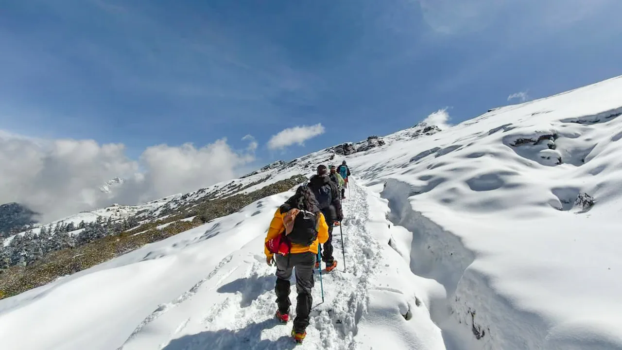
Gradual forest paths transitioning to alpine meadows and ending in a 4-hour technical snow-ridge ascent. The ridge has 60-degree snow slopes.
Summit Day Notes
Altitude: 15,069ft. 12-hour summit push. This is a mini-mountaineering expedition. Mental grit is as important as physical stamina.
The Descent
Hard on quads and knees. 5,000ft drop to Auli/Joshimath. Use anti-shock poles.
Altitude Profile
9.3k -> 11.1k -> 15k. The jump on summit day is nearly 4,000ft in 4 hours. Extreme altitude stress.
Run AMS Risk Audit →Trail Performance Data
Max Gradient
45%
Hydration
0.5L per km recommended
Loose Surface Sections
- •Guling to Dhak descent
- •Upper ridge rocky scramble
Personal Readiness
Am I ready?
What this route demands
People who feel comfortable on this route can usually:
Who Can Do This Trek?
Min Age
12+
Max Age
55
Western Toilets at Base
Yes
Solo Female Travelers
Very high; Joshimath is a bustling base. Mountain ridges are secluded but guided teams are frequent.
Hazard Profile
What goes wrong?
Common Mistakes on Pangarchulla Peak Trek
Most injuries and failures on this trail can be avoided by making smarter decisions early on.
Bringing beginners — this is a peak trek, not a meadow walk.
Wearing low-ankle shoes — snow will enter and cause frost-nip in 2 hours.
Rushing at 14,000ft — causes immediate nausea/vomiting.
Not practicing with microspikes before the summit morning.
Thinking Kuari Pass and Pangarchulla are same difficulty — Pangarchulla is 3x harder.
Safety & Medical Risks
Key Risks
Extreme rapid altitude gain on summit day (4,000ft elevation jump)
Knife-edge ridge crossing near the summit (fall risk)
Snow blindness due to high glare on summit fields
Hypothermia at Khullara/Ridge due to high winds
AMS (Altitude Sickness)
The jump from 11k to 15k is the primary danger. Monitor for disorientation.
Evacuation Route
Manual stretcher to Auli chairlift/road-head, then ambulance to Joshimath.
Solo Trekking
NOT RECOMMENDED. The summit ridge requires rope-work and expert navigation in snow. Permits for solo peak-climbs are usually restricted.
Common Trail Ailments
🏥 Nearest ICU: AIIMS Rishikesh / Max Super Specialty Hospital, Dehradun
Tactical Emergency Hub
> 1 day rapid descent to Auli roadhead or Dhak village; then 45 mins drive to Joshimath Military Hospital/Community HC.
Auditability
How is this calculated?
Understand This Route Further
Before attempting this route:
Still deciding?
Compare routes side-by-side to find the perfect match for your fitness, dates, and budget.
Still think it's doable? Share this with your trek mate and see if they agree.
Step 2: Seasonal Safety
You know how demanding this route is.
Now find the safest and most reliable season to attempt it.
Check Best Time to Go