Essential Planning Guide
Nanda Devi East Base Camp Trek — Complete Guide (2026)
Introduction
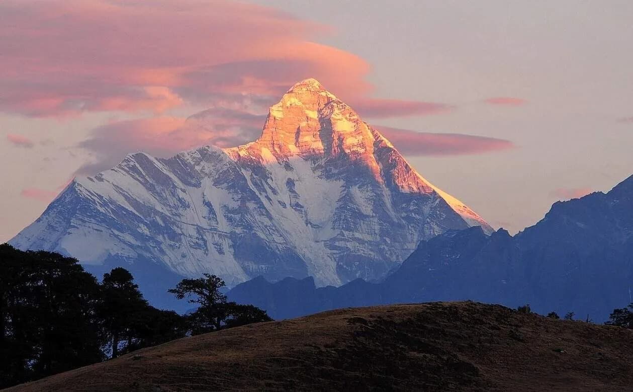
The Nanda Devi East Base Camp trek is arguably the most prestigious and awe-inspiring trek in the Kumaon region. While the inner sanctuary of the main Nanda Devi peak (25,643 ft) was permanently closed to all human presence in 1983 to protect its fragile ecosystem, the eastern face—Nanda Devi East (24,390 ft)—remains accessible to determined trekkers. Starting from the legendary town of Munsiyari, the route plunges deep into the historic Johar Valley, tracing the raging Gori Ganga river along the ancient Indo-Tibetan trade route. Trekkers navigate deeply cut, precarious gorges before swinging west at the abandoned village of Milam, gaining rapid altitude to reach the Pachhu glacier. Standing at Base Camp, trekkers are rewarded with a direct, unobstructed, and utterly terrifying view of the sheer, seemingly vertical eastern ice-wall of Nanda Devi. It is a long, physically grueling trek reserved for fit individuals seeking absolute high-alpine isolation.
Ready to book? Compare verified operators for Nanda Devi East Base Camp Trek — transparent pricing, no paid rankings.
Quick Facts
Duration
Max Altitude
Difficulty
Best Time
Trek Distance
Trail Atmosphere
Stargazing
Class 1 Dark Sky
Scent Profile
Silence Level
~10 dB
Vertigo Factor
4 / 10
Primarily a cumulative fatigue and cardio demand challenge
A demanding expedition with extreme cumulative fatigue and cardio demand.
Iconic Spots
Pachhu Base Camp
Getting There
Route to Base
Train to Kathgodam in the morning
Share a Max Jeep for 10-12 hours via Almora and Thal directly to Munsiyari
Base Village
Munsiyari
7,200 ft
Last ATM
Munsiyari
Nearest Medical Facility
Munsiyari Main Hospital
Mobile Signal
Total dark zone after starting from Munsiyari.
Water Sources
Abundant glacial streams along the entire gorge.
Charging
Zero charging after Munsiyari.
For Drivers
Road Condition
Kathgodam to Munsiyari is one of the longest, most exhaustive uninterrupted hill drives in the state.
Munsiyari
Trail Culinary & Diet
Don't miss the N/A
Buy specialized diet items at Munsiyari
The Content & Remote Hub
No DronesStrictly illegal. You are walking right next to high-alert Indo-Tibetan border lines.Top Vlog Spots
Video Calls
none
Est. 0 Mbps
UPI Reliability
1/10
Base WiFi Available
Guide Wisdom
Caution
Walk in absolute single-file silence through the rock-blasted gorge near Bugdiyar. Looking up and disturbing loose scree can trigger fatal rockfalls on the people behind you.
Explore In Detail
Day by Day Itinerary
10-day route reaching 13,615ft. Covers 103km of varied terrain.
→ See full itinerary with altitude profileDifficulty & Fitness
Rated challenging. Exceptional variety. The lower gorge consists of dangerous, rock-blasted cliff trails. The middle sections are vast, treeless alpine plateaus. The final push is hard glacial moraine.
→ See difficulty breakdown and fitness guideCost & Pricing
Packages range from ₹30,000 - ₹50,000. Inclusions and hidden costs vary by operator tier.
→ See full cost breakdownPermits and Regulations
Heavily restricted. An Inner Line Permit (ILP) is required from the SDM office in Munsiyari due to border proximity. Indian nationals require Police Verification and Aadhar. Foreign Nationals face severe restrictions, requiring deep background checks and sometimes outright denial if border tensions are high.
Learn more about how we vet operators and ensure transparency on our why MountRoutes page.
Packing List
High-Alpine Weather Gear
- Premium Expedition Grade Sleeping Bag (-15°C comfort rating minimum for Pachhu)
- Ultra-heavy down jacket (Winds cascading off the Nanda Devi massif are bone-chilling)
- Gore-Tex Hardshell pants and jacket (The Johar valley funnels weather rapidly)
Footwear
- Waterproof high-ankle trekking boots (Crucial. The trail has numerous river crossings and rock-falls)
- Camp shoes/Crocs (To give your feet relief during the 10-day slog)
- 4 pairs of heavy merino wool socks
Navigation & Sustainability
- Solar power bank (Absolutely no electricity past Bugdiyar)
- Water purification system (Lifestraw/SteriPEN) - 100% mandatory for glacier runoff
- Trekking poles with hard carbride tips
Flora & Fauna
Flora
Fauna
Nanda Devi is the patron goddess of the entire Uttarakhand region. The inner sanctuary was historically considered her literal impregnable fortress.
— Local folklore
Spiritual & Cultural Significance
Deep worship of Nanda Devi. The mountain is technically considered living theology in Kumaon.
🕐 Shrine Timings: N/A
Temple Protocols
Frequently Asked Questions
Can I see the main Nanda Devi peak from this trek?
You see Nanda Devi East (24,390 ft). The main peak is partially hidden behind it, but the eastern face is considered one of the most sheer, terrifying rock and ice walls in the world.
Is the Nanda Devi Inner Sanctuary open?
No. The main inner sanctuary has been strictly closed since 1983. This trek goes to the *East* base camp outside the restricted inner ring.
How long is the actual walking?
It is a massive trek. You will walk nearly 110 kilometers round-trip over 8 days of actual trekking. High physical stamina is non-negotiable.
Are there ITBP checkposts?
Yes, heavily. You are walking parallel to the international border towards Milam. Registration at multiple Indo-Tibetan Border Police checkposts is mandatory.
Is there KMVN infrastructure?
Basic temporary dhabas (tea houses) exist up to Bugdiyar and Mapang, but past that, you must rely on expedition tents. The old villages like Milam are mostly abandoned in winter.
What is the peak altitude?
The highest sleeping altitude is at Pachhu (Base Camp) which sits at roughly 13,615 feet. Acclimatization is manageable because the approach is very long.
Is the trail dangerous?
The trail through the Gori Ganga gorge is carved directly into the cliff faces. It is narrow, prone to massive landslides, and physically demanding. Extreme caution is required.
Where does it start?
The trek starts from Munsiyari, though new road extensions have pushed the immediate starting point slightly closer to Lilam.
Is the route crowded?
No. Unlike Roopkund or Kedarkantha, the sheer distance from major cities and the 10-day requirement keeps this route extremely quiet and pristine.
Can I combine this with the Milam Glacier trek?
Yes. Most trekkers add 2 days to visit the snout of the Milam glacier before cutting west toward Nanda Devi East Base Camp.
Other Treks Guides
Still deciding?
Compare routes side-by-side to find the perfect match for your fitness, dates, and budget.
Everything you need to know, in one place. Someone else in your group needs to see this.
Planning Nanda Devi East Base Camp Trek?
Get route conditions, operator updates, and season windows before booking.
No spam. Only useful updates.
Ready to walk this route?
You’ve read the guide, now find the perfect local team to take you there. Compare our verified list of operators.
Compare verified operators