Explore
Intelligence
Essential Planning Guide
Kuari Pass Trek — Complete Guide (2026)
Vibe & Scenery
The Experience
Introduction
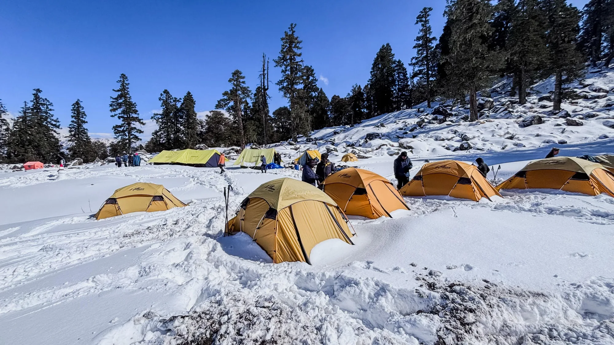
The Kuari Pass Trek follows the historic Curzon Trail through the Garhwal Himalayas, combining ancient oak forests, rolling alpine meadows, and broad mountain ridges into one of Uttarakhand's most iconic trekking experiences. The route gradually ascends to Kuari Pass at approximately 12,516 ft, revealing sweeping views of peaks including Nanda Devi, Dronagiri, Kamet, Chaukhamba, and Hathi-Ghori Parbat.
Seasonal changes transform the landscape throughout the year, from snow-covered forests during winter to rhododendron blooms in spring and lush green meadows after the monsoon. The varied terrain and moderate gradients make it accessible to fit beginners while remaining rewarding for experienced trekkers.
Combining rich mountain scenery with historical significance, Kuari Pass remains one of the finest introductory high-altitude treks in the Indian Himalayas.
Quick Facts
Duration
Max Altitude
Difficulty
Best Time
Trek Distance
Trail Atmosphere
Stargazing
Class 3 Dark Sky
Scent Profile
Silence Level
~35 dB
Vertigo Factor
2 / 10
Iconic Spots
Gorseon Bugyal
Kuari Top (12,516 ft)
Environment
Nature & Culture
Flora & Fauna
Flora
Fauna
Historically known as 'Lord Curzon's Trail'. The pass was a key spiritual and trade route between Nanda Devi and Dhauliganga valleys.
— Local folklore
Spiritual & Cultural Significance
Near Joshimath (Adi Shankara Math) and Badrinath route.
🕐 Shrine Timings: Daylight (Padiyar Temple)
Temple Protocols
- •Remove footwear before temple perimeter
Technical Details
Challenge & Preparation
Primarily a cardio demand challenge
A welcoming route that balances cardio demand and altitude exposure.
Personal Readiness
Am I ready?
Planning
Logistics & Trail Intel
Getting There
Route to Base
10-hour drive from Dehradun/Rishikesh
Early morning (5 AM) shared jeeps from Rishikesh Natraj Chowk are the most reliable local transport
Base Village
Joshimath
6,150 ft
Nearest Railhead
Rishikesh
Nearest Airport
Jollygrant Airport
Last ATM
Joshimath Main Market. Multiple reliable ATMs like SBI and HDFC. No ATMs at Dhak or campsites.
Nearest Medical Facility
Joshimath District Hospital or Army Hospital (for emergencies). Highly reliable in the region.
Mobile Signal
Airtel/Jio strong at Joshimath/Auli. Intermittent signal at Gulling camp; zero at Tali/Pass.
Water Sources
Ample at Tali and Gulling camps. Padiyar temple spring is sacred and reliable year-round.
Charging
Zero electricity beyond Auli/Joshimath base. Carry high-capacity power banks.
For Drivers
Road Condition
Good road (Joshimath Highway hub). Final stretch to Auli is winding but well-paved.
Joshimath
Trail Culinary & Diet
Don't miss the Garhwali Kafuli
Buy specialized diet items at Joshimath
The Content & Remote Hub
Top Vlog Spots
Video Calls
base-only
Est. 15 Mbps
UPI Reliability
5/10
Base WiFi Available
Permits and Regulations
Kuari Pass falls within the Nanda Devi Biosphere Reserve buffer zone. A forest entry permit from the Joshimath Range Office is mandatory. This is typically pre-arranged by operators, but solo trekkers can obtain it at the Dhak/Tugasi forest checkpost. Valid Indian ID (Aadhar/Passport) is mandatory. Foreign nationals must provide passport and visa copies for registration at the Joshimath police station.
Learn more about how we vet operators and ensure transparency on our why MountRoutes page.
Packing List
Winter Clothing
- Heavy down jacket rated to -15°C
- 3 thermal base layers (full sleeve)
- 2 fleece mid layers
- Hardshell waterproof outer layer
- Insulated, waterproof trek pants
- Heavyweight wool socks (4 pairs)
- Insulated waterproof gloves + liner gloves
- Balaclava and thermal skull cap
Footwear Snow Gear
- Insulated waterproof trekking boots (Vibram sole preferred)
- Micro-spikes or micro-crampons (for the pass ridge)
- Four-season gaiters
- Camp boots for tent use
Gear Safety
- Trekking poles (Extremely important for Auli descent)
- High-lumen headlamp with extra lithium batteries
- Sleeping bag rated -10°C minimum
- Sunglasses UV400 (mandatory for snow)
- Sunscreen SPF 50+
- Personal medical kit (Diamox, Kneecaps, Blister tapes)
Deep Dives
Explore Further
Editor's Notes
Named after the Viceroy of India trek here in 1905, this trail was the original route into the Nanda Devi Biosphere before the 1980s closure.
The 360-degree views of Nanda Devi, Chaukhamba, and Dronagiri from a trek under 13,000ft is arguably the best value-to-altitude ratio in the Himalayas.
Explore In Detail
Day by Day Itinerary
6-day route reaching 12,516ft. Covers 36km of varied terrain.
→ See full itinerary with altitude profileDifficulty & Fitness
Rated accessible. The trail is mostly well-paved stone paths through villages, transitioning into soft forest floor during the mid-section. The final 3km to the pass is a rocky ridge walk. In winter, this ridge becomes narrow and requires Microspikes for safety on hard-packed ice.
→ See difficulty breakdown and fitness guideCost & Pricing
Packages range from ₹8,500 – ₹15,500. Inclusions and hidden costs vary by operator tier.
→ See full cost breakdownFrequently Asked Questions
How difficult is the Kuari Pass Trek?
It is classified as a moderate trek. It takes 6 days and reaches a maximum altitude of 12516 ft. Trekkers should have steady cardiovascular endurance.
What is the risk of Acute Mountain Sickness (AMS) on the Kuari Pass Trek?
Since the trail climbs up to 12516 ft, there is a distinct risk of AMS. Proper hydration, progressive pacing, and gradual acclimatization are highly advised.
When is the absolute best time to do Kuari Pass Trek?
Kuari Pass is famously known as 'Lord Curzon's Trail' and is India's premier high-altitude winter trek. While accessible most of the year, December–March offers a classic snow experience. April–June is for rhododendrons and emerald meadows. Autumn (Sept–Nov) has the clearest peak views.
Will I get mobile network or internet connectivity during Kuari Pass Trek?
Connectivity is highly sporadic. The last reliable mobile signal is at Joshimath. Expect complete digital isolation on the trail.
Where is the last reliable ATM before starting the Kuari Pass Trek?
The last active ATM is located at Joshimath Main Market. Multiple reliable ATMs like SBI and HDFC. No ATMs at Dhak or campsites.. It is strongly recommended to withdraw sufficient cash at major transit hubs before starting.
Is the drinking water safe on the Kuari Pass Trek trail?
Fresh stream water is abundant, but water treatment is mandatory. filters
Can I rent trekking gear at Joshimath?
Rental options at Joshimath are extremely limited. It is best to rent or purchase all essential gear in major hubs before reaching the base.
What permits are required for the Kuari Pass Trek?
Kuari Pass falls within the Nanda Devi Biosphere Reserve buffer zone. A forest entry permit from the Joshimath Range Office is mandatory. This is typically pre-arranged by operators, but solo trekkers can obtain it at the Dhak/Tugasi forest checkpost. Valid Indian ID (Aadhar/Passport) is mandatory. Foreign nationals must provide passport and visa copies for registration at the Joshimath police station.
What is the emergency evacuation protocol on the Kuari Pass Trek?
Quick evacuation to Auli roadhead via porter (2-3 hrs from lower camps). Joshimath has major Army/Civil medical centers. In case of extreme emergencies, helicopter evacuation can be coordinated if weather allows.
Where is the nearest specialized ICU or hospital for Kuari Pass Trek?
The nearest specialized ICU is Dehradun (Max/Jollygrant). For minor injuries, the nearest primary health center is located at Joshimath District Hospital or Army Hospital (for emergencies). Highly reliable in the region..
Is it safe to do the Kuari Pass Trek as a solo female or solo traveler?
Highly popular and safe for solo trekkers during peak months (May, Oct, Dec). However, solo trekking in deep winter snow is highly discouraged as trails vanish and visibility can drop to zero in minutes. The local communities are exceptionally welcoming and hospitable, but having a guide is highly recommended.
Are foreign nationals allowed to do the Kuari Pass Trek?
Yes, but foreign nationals require specialized inner line permits and a registered local agency/guide to join.
What kind of food is served during the Kuari Pass Trek?
We serve highly nutritious, warm vegetarian meals suitable for high altitudes. You will also get to taste Garhwali Kafuli on the trail.
Are digital UPI/online payments accepted at the base village of Joshimath?
While some local shops accept UPI at Joshimath, connection is highly unreliable due to network dropouts. Make sure to carry physical cash.
What is the local cultural significance or folklore associated with Kuari Pass Trek?
Historically known as 'Lord Curzon's Trail'. The pass was a key spiritual and trade route between Nanda Devi and Dhauliganga valleys.
Route Intelligence
Routes With Similar Character
Routes that share the character of Kuari Pass Trek.
Ali & Bedni Bugyal Trek
Both are characterized by expansive bugyals (meadows) and open ridgewalks. They share multiple characteristics.
Dayara Bugyal Trek
Both serve as excellent introductions to multi-day Himalayan trekking. They share multiple characteristics.
Har Ki Dun Trek
Both serve as excellent introductions to multi-day Himalayan trekking. They share multiple characteristics.
Still deciding?
Compare routes side-by-side to find the perfect match for your fitness, dates, and budget.
Everything you need to know, in one place. Someone else in your group needs to see this.
Planning Kuari Pass Trek?
Get route conditions, operator updates, and season windows before booking.
Don't miss out! Follow us for route updates@mountroutes|LinkedIn
No spam. Only useful trek updates.
Ready to walk this route?
You’ve read the guide, now find the perfect local team to take you there. Compare our verified list of operators.
Compare verified operators