
Explore
Intelligence
Essential Planning Guide
Kanakata Pass Trek — Complete Guide (2026)
Vibe & Scenery
The Experience
Introduction
Hidden beyond the well-known Sunderdhunga Glacier trail, Kanakata Pass is one of Kumaon's most remote expedition objectives. The journey explores the spectacular Sunderdhunga Valley before leaving established trekking routes behind to enter increasingly rugged glacial terrain.
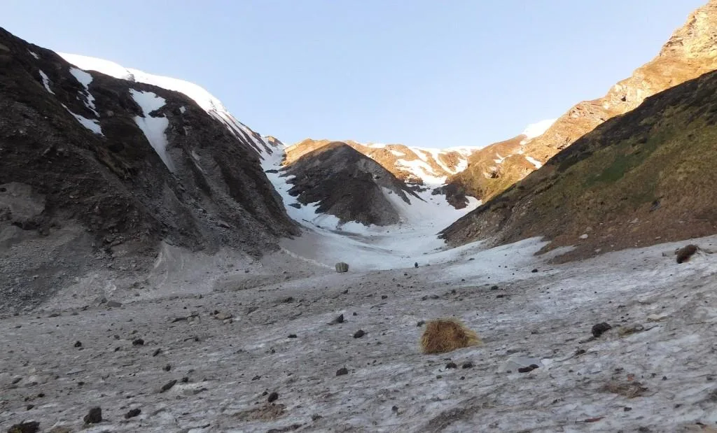
The trail passes alpine lakes including Devi Kund and Nag Kund before climbing towards Kanakata Pass through boulder fields, steep scree slopes, and rocky mountain ridges. Throughout the expedition, trekkers remain surrounded by some of Kumaon's finest peaks, including Maiktoli, Panwali Dwar, Mrigthuni, and neighbouring glacier systems.
Unlike more popular Kumaon treks, Kanakata Pass receives very few visitors. Its combination of isolation, technical terrain, and sustained high-altitude travel makes it a genuine expedition rather than a conventional trekking holiday, rewarding experienced mountaineers with one of the region's wildest Himalayan landscapes.
Quick Facts
Duration
Max Altitude
Difficulty
Best Time
Trek Distance
Trail Atmosphere
Stargazing
Class 1 Dark Sky
Scent Profile
Silence Level
~20 dB
Vertigo Factor
8 / 10
Iconic Spots
Devi Kund
Kanakata Pass Summit
Environment
Nature & Culture
Flora & Fauna
Flora
Fauna
Devi Kund and Nag Kund are considered sacred glacial lakes by the local Bhotiya communities, housing protective mountain deities.
— Local folklore
Spiritual & Cultural Significance
The glacial lakes (Kunds) are revered by locals. Bathing in them is strictly prohibited.
Temple Protocols
- •Remove shoes near any small trailside shrines.
Technical Details
Challenge & Preparation
Primarily a joint & muscle impact and cumulative fatigue challenge
A demanding expedition with extreme joint & muscle impact and cumulative fatigue.
Personal Readiness
Am I ready?
Planning
Logistics & Trail Intel
Getting There
Route to Base
Take an overnight train to Kathgodam, followed by a 9-hour drive via Almora and Bageshwar to the roadhead at Kharkiya
Base Village
Kharkiya / Khati
7,250 ft
Last ATM
Bageshwar
Nearest Medical Facility
Primary Health Center in Kapkot, Major hospital in Bageshwar
Mobile Signal
None.
Water Sources
Abundant glacial streams up to Baluni Top. Carry sufficient water for the pass crossing day as tarns may be frozen.
Charging
Only available in Khati (via solar/hydro). None beyond.
For Drivers
Road Condition
The road from Bageshwar to Kharkiya is prone to landslides and is unpaved in the final stretches.
Bageshwar
Trail Culinary & Diet
Don't miss the Bhatt ki Churkani (Black Bean Curry) in Khati.
Buy specialized diet items at Kathgodam / Almora
The Content & Remote Hub
No DronesProhibited inside the Nanda Devi Biosphere buffer zones.Top Vlog Spots
Video Calls
none
Est. 0 Mbps
UPI Reliability
1/10
Permits and Regulations
The trek passes through the sensitive Nanda Devi Biosphere Reserve buffer zones. Forest permits from the Bageshwar/Kapkot Forest Department are mandatory. Due to its proximity to the Pindari region, group sizes are regulated.
Learn more about how we vet operators and ensure transparency on our why MountRoutes page.
Packing List
High-Altitude Clothing
- Heavy down jacket (-10°C to -15°C rating)
- Gore-Tex Hardshell jacket and waterproof pants
- Merino wool baselayers (upper and lower)
- Fleece mid-layers
- Waterproof alpine gloves with thermal liners
- Balaclava and UV-protective Buff
- Multiple pairs of heavy woolen trekking socks
Footwear
- High-ankle waterproof trekking boots with stiff soles
- Heavy-duty waterproof gaiters (for snow and mud)
- Microspikes (crampons if trekking in early May/late October)
- Camp shoes or sandals
- Anti-shock trekking poles with snow baskets
Survival & Medical
- Category 4 Glacier Glasses
- High-lumen headlamp with spare lithium batteries
- Personal medical kit (Diamox, Dexamethasone, Ondansetron)
- High SPF Sunscreen (50+) and zinc oxide lip balm
- Insulated Nalgene water bottles
Camping & Gear
- Four-season sleeping bag (rated to -15°C)
- Insulated sleeping mat
- 60-70L expedition backpack with rain cover
- Dry bags for electronics and clothing
- Multi-tool and duct tape for gear repair
Deep Dives
Explore Further
Editor's Notes
Explore In Detail
Day by Day Itinerary
9-day route reaching 15,091ft. Covers 85.0km of varied terrain.
→ See full itinerary with altitude profileDifficulty & Fitness
Rated challenging. The route transitions from well-trodden village paths to dense forest trails with landslide hazards, eventually becoming a brutal moraine and scree slog above 12,000 ft.
→ See difficulty breakdown and fitness guideCost & Pricing
Packages range from ₹20,000 – ₹35,000+. Inclusions and hidden costs vary by operator tier.
→ See full cost breakdownFrequently Asked Questions
Is the Kanakata Pass Trek suitable for beginners?
Absolutely not. This is a challenging, high-altitude trek requiring significant prior experience in the Himalayas. The terrain involves steep rock slabs, scree, and potential snow crossings above 14,000 ft.
What is the difference between the Sunderdhunga Trek and Kanakata Pass?
The standard Sunderdhunga trek goes up to Kathalia and the Sunderdhunga glacier snout (approx 10,500 ft). Kanakata Pass is a severe extension from Kathalia, climbing an additional 4,500 vertical feet past Baluni Top and Devi Kund to reach the 15,091 ft pass.
Do I need technical mountaineering gear?
While it is not a technical peak climb, early season (May) or late season (late October) attempts may require microspikes, gaiters, and an ice axe for safely negotiating steep, icy gullies.
Where is the last point of mobile connectivity?
BSNL networks may work intermittently in Khati village. Beyond Khati, there is absolutely no mobile connectivity for the remaining 7 days of the trek.
Can this trek be done during the monsoon?
No. The Sunderdhunga valley is prone to severe landslides, and the glacial streams become uncrossable torrents in July and August. Attempting this in the monsoon is highly dangerous.
Are there teahouses or homestays on the trail?
Homestays are available in Khati and Jatoli. Beyond Jatoli, you must be fully self-sufficient with high-altitude expedition tents and rations.
What happens if someone suffers from AMS?
Immediate descent is the only cure. The terrain makes helicopter evacuation extremely difficult. Trekkers must be prepared to carry down an affected team member via stretcher or mule.
Is a local guide mandatory?
Yes. The trail beyond Kathalia is completely unmarked, frequently washed out by rockfall, and highly deceptive. A local guide from Khati or Jatoli is essential for route finding.
Still deciding?
Compare routes side-by-side to find the perfect match for your fitness, dates, and budget.
Everything you need to know, in one place. Someone else in your group needs to see this.
Planning Kanakata Pass Trek?
Get route conditions, operator updates, and season windows before booking.
Don't miss out! Follow us for route updates@mountroutes|LinkedIn
No spam. Only useful trek updates.
Ready to walk this route?
You’ve read the guide, now find the perfect local team to take you there. Compare our verified list of operators.
Compare verified operators