Essential Planning Guide
Gidara Bugyal Trek — Complete Guide (2026)
Introduction
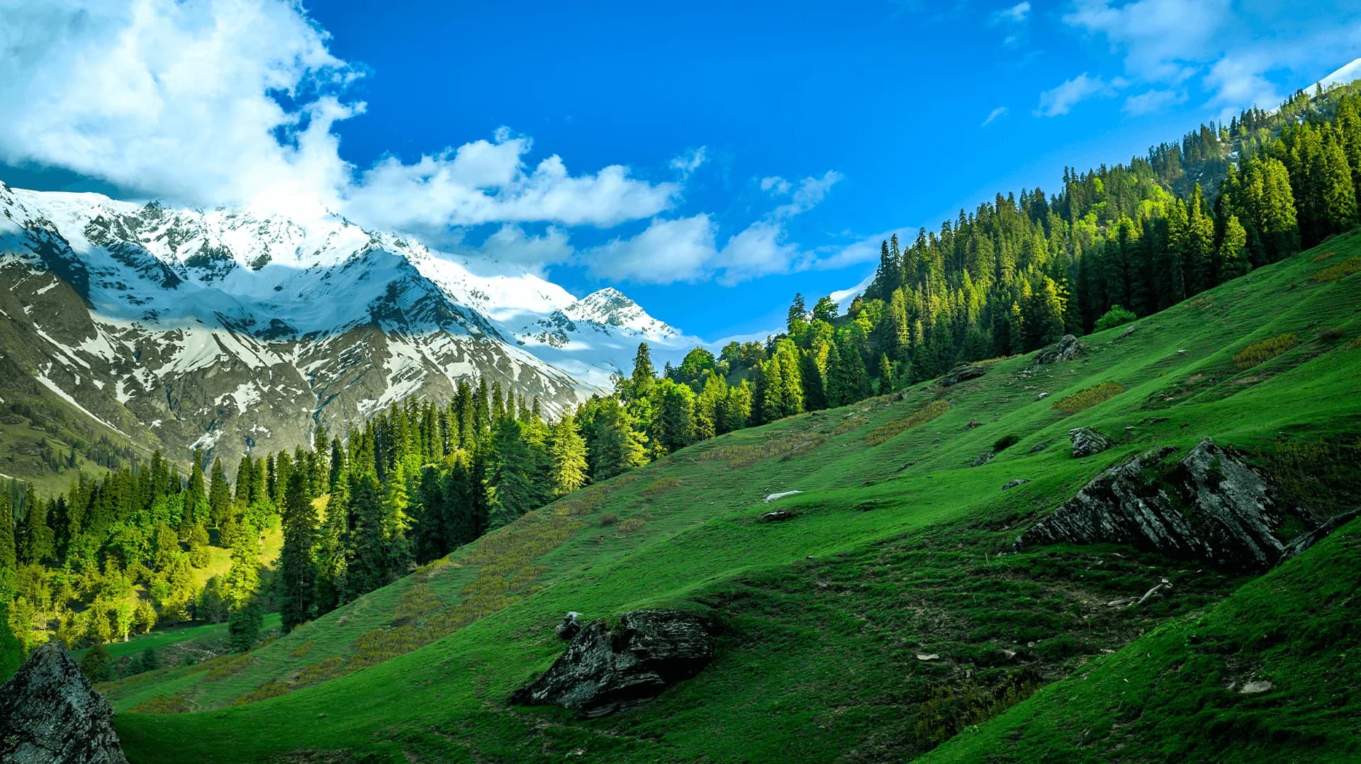
Hidden deep in the Uttarkashi district, Gidara Bugyal is unofficially considered the largest high-altitude alpine meadow in Asia—dwarfing popular counterparts like Dayara Bugyal and Ali Bedni in both sheer size and absolute isolation. While Dayara is a beginner-friendly 11,000 ft plateau, Gidara is a wildly remote, sprawling green ocean that peaks at an altitude of nearly 14,000 ft. A trek here guarantees total seclusion; it is highly common to complete the entire 7-day circuit without encountering another human group outside of local Gujjar shepherds. The trek demands high fitness levels due to the notoriously steep and muddy ascents through dense, ancient oak forests before finally breaking the treeline into an endless panorama of the Gangotri massif, including direct, uninterrupted views of Bandarpoonch, Gangotri I, II, and III.
Ready to book? Compare verified operators for Gidara Bugyal Trek — transparent pricing, no paid rankings.
Quick Facts
Duration
Max Altitude
Difficulty
Best Time
Trek Distance
Trail Atmosphere
Stargazing
Class 1 Dark Sky
Scent Profile
Silence Level
~10 dB
Vertigo Factor
3 / 10
Primarily a joint & muscle impact and altitude exposure challenge
A capable trekker's route dominated by extreme joint & muscle impact.
Iconic Spots
Gidara Top 270
Getting There
Route to Base
Drive from Dehradun past Uttarkashi towards Gangotri
Stop at the Bhangeli roadhead and climb 3km up
Base Village
Bhangeli
8,500 ft
Nearest Railhead
Rishikesh / Dehradun
Nearest Airport
Jollygrant Airport (Dehradun)
Last ATM
Uttarkashi
Nearest Medical Facility
Uttarkashi District Hospital
Mobile Signal
Drops dead past Bhangeli.
Water Sources
Running streams till Rikla. The high ridges (Thalot, Gidara Top) are bone dry.
Charging
Zero charging after Bhangeli.
For Drivers
Road Condition
Dehradun to Uttarkashi is smooth. The rest is narrow mountain single-lanes.
Uttarkashi
Trail Culinary & Diet
Don't miss the N/A
Buy specialized diet items at Uttarkashi
The Content & Remote Hub
No DronesStrictly restricted under Forest guidelines.Top Vlog Spots
Video Calls
none
Est. 0 Mbps
UPI Reliability
1/10
Guide Wisdom
Caution
Fill every water bottle and hydration pack you own at Dokrani before pushing for the top ridge. The high bugyals are completely, bone dry.
Explore In Detail
Day by Day Itinerary
7-day route reaching 13,900ft. Covers 38km of varied terrain.
→ See full itinerary with altitude profileDifficulty & Fitness
Rated moderate. The forest sections are steep, muddy, and covered in slippery roots. The high bugyals are undulating but feature very steep ramparts to actually access the highest ridges.
→ See difficulty breakdown and fitness guideCost & Pricing
Packages range from ₹8,000 – ₹15,000. Inclusions and hidden costs vary by operator tier.
→ See full cost breakdownPermits and Regulations
Required. Permits must be arranged through the Uttarkashi Forest Department. The trail traverses sensitive ecological zones and traditional Gujjar pastoral lands. Strict Leave-No-Trace principles are enforced regarding plastic wraps and campfire bans above the treeline.
Learn more about how we vet operators and ensure transparency on our why MountRoutes page.
Packing List
High-Alpine Clothing
- Premium Windproof Hardshell Jacket (Winds sweep the high 13.9k ft ridge relentlessly)
- Down jacket (Meadow camps like Dokrani and Thalot drop below 0°C at night)
- Waterproof trekking pants (Quick-dry, absolutely no cotton)
Footwear
- Waterproof high-ankle trekking boots (Crucial. Morning dew and wet grass will soak standard shoes in 5 minutes)
- Gaiters (For early summer hikes traversing residual snow patches)
- 3 pairs of merino wool socks
Trekking Essentials
- Trekking poles (Indispensable for the steep ascents out of Bhangeli and the brutal descents)
- Premium hydration bladder (Water sources are extremely far apart on the actual bugyal ridge)
- UV 400 Polarized Sunglasses
Flora & Fauna
Flora
Fauna
The staggering size of the meadows led ancient pastoralists to believe it was carved by the gods exclusively for their celestial cattle.
— Local folklore
Spiritual & Cultural Significance
Revered purely by Gujjar pastoralists as divine foraging ground.
🕐 Shrine Timings: N/A
Temple Protocols
Frequently Asked Questions
How does Gidara compare to Dayara Bugyal?
Gidara is dramatically larger, significantly higher (13,900 ft vs 11,500 ft), vastly more remote, and considerably harder to trek. Dayara is a beginner trek; Gidara is a strict moderate-to-difficult trek.
Is Gidara Bugyal for beginners?
No. The initial altitude gain from Bhangeli is extremely aggressive, and the highest camp sits at over 13,000 ft, posing a legitimate AMS risk. Previous trekking experience is mandated.
Which peaks are visible from Gidara Top?
You get a sweeping, 270-degree panorama of the Gangotri massif—including Bandarpoonch, Black Peak (Kalanag), Srikantha, and the Gangotri siblings (I, II, III).
Are there leeches on the trail?
Yes. If trekking right after the monsoon in September, the deep oak and rhododendron forests on the ascent from Bhangeli are heavily infested with leeches.
Is water easily available on the Bugyal?
No. This is a common hazard. Once you crest the ridge onto the highest bugyal sections, water sources are extremely limited. You must carry at least 2 to 3 liters from the lower camps.
Can we camp directly on the top meadow?
You camp at the edges (like Thalot or Dokrani). Camping directly on the highest crests is prohibited by forest rules and functionally impossible due to wind exposure.
Will we see other trekking groups?
Highly unlikely. Gidara is far off the commercial radar. You will likely have hundreds of acres of alpine grass entirely to yourself.
Where does the trek start?
The trek typically begins at the remote village of Bhangeli, which is a dramatic, steep uphill walk just to reach the village from the river roadhead.
What is the hardest day?
Day 4. The push from Dokrani camp up the steepest flanks to the Gidara Top ridge (13,900 ft) is a grueling, oxygen-deprived climb.
Is mobile network available?
There is a very erratic BSNL signal near Bhangeli village. After that, it is a complete communications black hole for 6 days.
Other Treks Guides
Still deciding?
Compare routes side-by-side to find the perfect match for your fitness, dates, and budget.
Everything you need to know, in one place. Someone else in your group needs to see this.
Planning Gidara Bugyal Trek?
Get route conditions, operator updates, and season windows before booking.
No spam. Only useful updates.
Ready to walk this route?
You’ve read the guide, now find the perfect local team to take you there. Compare our verified list of operators.
Compare verified operators