Essential Planning Guide
Kanamo Peak Expedition — Complete Guide (2026)
Introduction
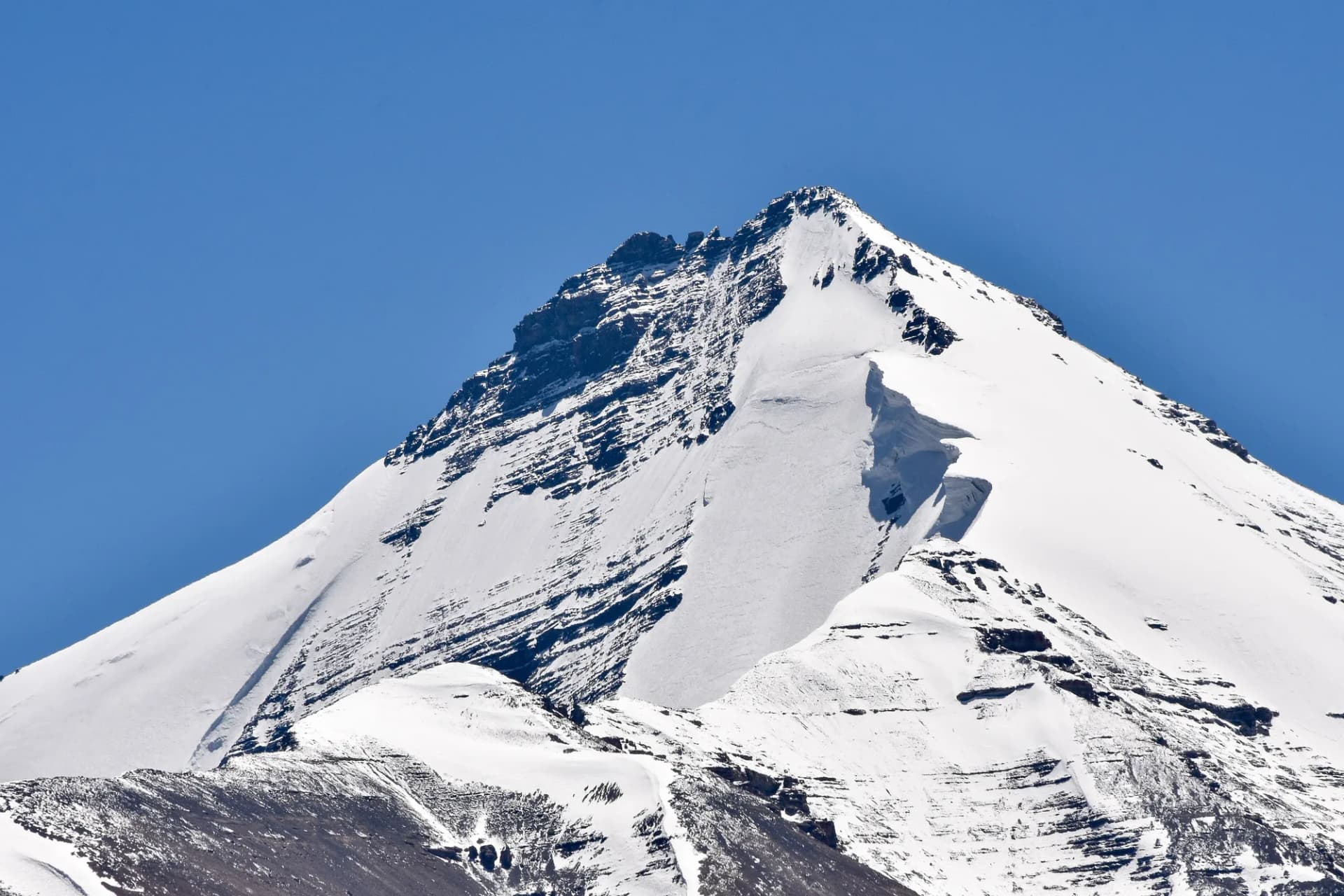
Mount Kanamo (19,600 ft / 5,974 m), known as the 'White Lady' of Spiti, is India's most accessible near-6,000m trekking peak. Perched above one of the world's highest inhabited villages — Kibber (14,200 ft) — it offers an extraordinary high-altitude summit experience without technical mountaineering prerequisites. The peak sits at the heart of the Cold Desert biosphere of Spiti Valley, Himachal Pradesh, and commands a 360-degree panorama encompassing the trans-Himalayan giants of Ladakh, the Tibetan Plateau, and the dramatic ridgelines of the Pin Valley National Park. It is the perfect objective for seasoned trekkers ready to make their first summit push above the 19,000ft threshold.
Ready to book? Compare verified operators for Kanamo Peak Expedition — transparent pricing, no paid rankings.
Quick Facts
Duration
Max Altitude
Difficulty
Best Time
Trek Distance
Trail Atmosphere
Stargazing
Class 1 Dark Sky
Scent Profile
Silence Level
~8 dB
Vertigo Factor
3 / 10
Primarily a joint & muscle impact and altitude exposure challenge
An elite-level undertaking with extreme joint & muscle impact, altitude exposure, and cardio demand. This route will push every dimension of your physical and mental endurance to the limit.
Iconic Spots
Kibber Village Sunrise
Kanamo Summit
Upper Scree Bowl at Dusk
Getting There
Route to Base
10-hour drive from Manali via Rohtang Pass and Kunzum Pass
Alternative route: 2-day drive from Shimla via Nako and Tabo
Base Village
Kibber
14,200 ft
Nearest Railhead
Shimla / Chandigarh
Nearest Airport
Bhuntar Airport (Kullu) / Chandigarh
Last ATM
Kaza (SBI/PNB ATMs — carry adequate cash)
Nearest Medical Facility
Kaza Community Health Centre
Mobile Signal
BSNL/Jio in Kaza and Kibber. Zero on trail and summit.
Water Sources
Glacial stream at Base Camp (seasonal). Snow melt above. Kibber village tap water is safe.
Charging
Electricity at Kaza hotels and Kibber homestays. Zero above Kibber.
For Drivers
Road Condition
Manali–Kaza road via Kunzum is unpaved and rocky in many sections. Prone to blockage post-rain. Atal Tunnel route is faster but longer.
Kaza
Trail Culinary & Diet
Don't miss the Spiti Thukpa (Noodle Soup) / Butter Tea
Buy specialized diet items at Manali / Kaza (basic supplies)
The Content & Remote Hub
No DronesProhibited within 5km of international border (covers summit area).Top Vlog Spots
Video Calls
kaza-only
Est. 15 Mbps
UPI Reliability
4/10
Base WiFi Available
The White Lady
Key point
Kanamo is one of the few peaks in the world where you can stand at 19,600 ft without ropes or technical gear and look at Tibet. It is a once-in-a-lifetime threshold crossing.
Key point
The Kibber locals call Kanamo 'Reo Purgyil's little sister'. The mountain is considered sacred by the village and has been climbed for centuries by nomadic herders tracking animals.
Explore In Detail
Day by Day Itinerary
7-day route reaching 19,600ft. Covers 38km of varied terrain.
→ See full itinerary with altitude profileDifficulty & Fitness
Rated extreme. Terrain and fitness requirements vary by season.
→ See difficulty breakdown and fitness guideCost & Pricing
Packages range from ₹36,000 – ₹61,000. Inclusions and hidden costs vary by operator tier.
→ See full cost breakdownPermits and Regulations
Kanamo Peak does not require an IMF expedition permit. Indian nationals require a Spiti Trekking Permit from the Kaza SDM office (free). Foreign nationals require an Inner Line Permit (ILP) valid for the Spiti restricted zone, obtainable online or at Shimla/Rekong Peo. All trekkers must register at the Kibber Police Post and the Kibber Village Forest Committee checkpoint. Drones are prohibited within 5km of the international border — which includes the Kanamo summit ridge. Camping is permitted only at designated sites: Kibber and Kanamo Base Camp.
Learn more about how we vet operators and ensure transparency on our why MountRoutes page.
Packing List
Expedition Clothing
- Heavy down jacket rated to -20°C
- 3 Thermal base layers (Merino wool preferred)
- 2 Fleece mid-layers
- Waterproof hardshell jacket and pants
- Woolen beanie and balaclava
- Waterproof insulated gloves and liner gloves
- 4 pairs of heavy woolen mountaineering socks
- Thermal underwear (top and bottom)
Footwear & Snow Gear
- Sturdy high-ankle waterproof trekking boots (Vibram sole mandatory)
- Micro-spikes (mandatory for summit snow ridge)
- High-calf waterproof gaiters
- Anti-shock telescopic trekking poles (2)
Camping & Survival
- 4-season sleeping bag rated to -20°C
- Inflatable sleeping mat (R-value 4+)
- UV400 Category 4 glacier sunglasses
- Sunscreen SPF 50+ and UV lip balm
- 30,000mAh power bank (lithium, cold-resistant)
- Headlamp with spare lithium batteries
- 3L water capacity (Nalgene + reservoir)
- Personal medical kit (Diamox, ORS, Ibuprofen, Bandages)
Flora & Fauna
Flora
Fauna
The peak is believed to be the abode of a protective mountain deity by the Kibber village. Herders never shout near the summit out of respect. The first light touching Kanamo's summit is considered a divine blessing for the village.
— Local folklore
Spiritual & Cultural Significance
The mountain is sacred to the Kibber community. The summit is a point of reverence, not conquest.
🕐 Shrine Timings: N/A
Temple Protocols
- •Do not shout near the summit ridge
- •Do not disturb cairns placed by locals
Festivals & Dates
Frequently Asked Questions
Is Kanamo a technical peak?
No. Kanamo is classified as a 'non-technical trekking peak'. You can summit with sturdy waterproof boots and trekking poles. Micro-spikes are strongly recommended for the final snow ridge in early season.
Do I need an IMF permit?
Kanamo does not require a formal IMF peak permit. However, a local trekking permit from the Kaza Sub-Divisional Magistrate (SDM) and registration at the Kibber police post are mandatory.
How high is the summit?
Kanamo summit stands at 5,974 meters or approximately 19,600 feet — just 26 meters below the 6,000m mark.
Do I need prior mountaineering experience?
Not technical mountaineering, but prior high-altitude trekking experience above 14,000 ft (e.g., Hampta Pass or Buran Ghati) is strongly recommended.
Why must I acclimatize in Kaza first?
Kaza sits at 12,500 ft. The jump from Manali (6,700 ft) to Kaza in a single drive is already a massive altitude gain. Spending 2 nights here lets your body build red blood cells before ascending to Kibber and Base Camp.
Can I see Tibet from the summit?
Yes. On clear days, you can see the Tibetan Plateau's flat expanse, the Changthang ranges, and the Losar valley in the east.
What is the base camp altitude?
The standard Kanamo Base Camp is set at approximately 15,800 ft (4,815 m), reached after a 5-6 hour trek from Kibber.
Is water available at Base Camp?
A seasonal glacial stream runs near Kanamo Base Camp from June to September. In late September, teams may need to melt snow. Always carry filtration tablets.
How long is the summit push?
The summit push typically starts at 3–4 AM and takes 6–8 hours to reach the top, followed by a 4–5 hour descent back to Base Camp or Kibber.
What peaks are visible from the top?
The panorama includes Chao Chao Kang Nilda, Shilla Peak, the Kinner Kailash range, the Losar valley glaciers, and the far brown ridgelines of the Tibetan Plateau.
Is a porter/mule available?
Porters are available from Kibber village. Mules can carry loads up to the base camp approach but cannot access the final rocky ascent.
What is the summit success rate?
Approximately 70–80% for well-acclimatized teams. The primary reasons for turning back are AMS symptoms and severe afternoon wind-chill.
Other Expeditions Guides
Still deciding?
Compare routes side-by-side to find the perfect match for your fitness, dates, and budget.
Everything you need to know, in one place. Someone else in your group needs to see this.
Planning Kanamo Peak Expedition?
Get route conditions, operator updates, and season windows before booking.
No spam. Only useful updates.
Ready to walk this route?
You’ve read the guide, now find the perfect local team to take you there. Compare our verified list of operators.
Compare verified operators