
Explore
Intelligence
Essential Planning Guide
Surya Top Trek — Complete Guide (2026)
Vibe & Scenery
The Experience
Introduction
While most trekkers turn back after reaching Dayara Bugyal, the trail continues across quieter alpine ridges towards Surya Top, one of the highest viewpoints in the region. This extension transforms an already beautiful meadow trek into a more complete high-ridge Himalayan experience.
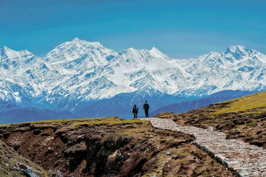
The route passes through Dayara Bugyal, Siyari Bugyal, and other seasonal grazing meadows before climbing to Surya Top, where expansive views stretch across Bandarpoonch, Black Peak (Kalanag), Draupadi Ka Danda, Srikanth, and much of the Gangotri massif.
Although technically straightforward, the longer distances and sustained climbing beyond Dayara require good fitness, making Surya Top an ideal objective for trekkers looking for a more rewarding alternative to the standard Dayara itinerary.
Quick Facts
Duration
Max Altitude
Difficulty
Best Time
Trek Distance
Trail Atmosphere
Stargazing
Class 2 Dark Sky
Scent Profile
Silence Level
~25 dB
Vertigo Factor
2 / 10
Iconic Spots
Surya Top Summit
Siyari Bugyal
Ancient Oak Forests
Environment
Nature & Culture
Flora & Fauna
Flora
Fauna
The massive bugyals have been the traditional summer grazing grounds for the villagers of Raithal and Barsu for centuries.
— Local folklore
Spiritual & Cultural Significance
The peaks visible from Surya Top (Gangotri range) hold deep religious significance in Hinduism as the source of the Ganges.
Temple Protocols
Technical Details
Challenge & Preparation
Primarily a cardio demand challenge
A capable trekker's route that balances cardio demand and cumulative fatigue.
Personal Readiness
Am I ready?
Planning
Logistics & Trail Intel
Getting There
Route to Base
Take an overnight train/bus to Dehradun
From Dehradun, it is an 8-hour drive via Uttarkashi to Raithal
Base Village
Raithal (Uttarkashi)
7,400 ft
Last ATM
Uttarkashi (Withdraw cash here before heading to Raithal).
Nearest Medical Facility
District Hospital, Uttarkashi.
Mobile Signal
Total blackout.
Water Sources
Forest streams near the camps. The summit ridge is completely dry.
Charging
Total blackout after Raithal.
For Drivers
Road Condition
Dehradun to Uttarkashi is an excellent, wide mountain highway. The final 30km to Raithal is a narrower, steeper village road.
Uttarkashi
Trail Culinary & Diet
Don't miss the Garhwali Rajma in Raithal
Buy specialized diet items at Dehradun / Uttarkashi
The Content & Remote Hub
Top Vlog Spots
Video Calls
base_village_only
Est. 5 Mbps
UPI Reliability
4/10
Permits and Regulations
Standard trekking permits are required from the Uttarkashi Forest Department. The operator will arrange these, but you must carry an original government ID.
Learn more about how we vet operators and ensure transparency on our why MountRoutes page.
Packing List
Clothing
- Heavy fleece jacket or down jacket
- Gore-Tex windproof outer shell
- Thermal inner wear (1 set for sleeping)
- Quick-dry trekking trousers (x2)
- Warm woolen cap
Footwear & Protection
- High-ankle trekking boots (broken in)
- Merino wool socks (x3 pairs)
- Waterproof gaiters (for early season snow on the ridge)
- Microspikes (if trekking in April/May)
Camping & Gear
- 40-50L backpack with rain cover
- Trekking poles (essential for the descent from Surya Top)
- 3-season sleeping bag (-5°C rating)
- Headlamp with spare batteries
Health & Essentials
- Personal first aid kit (Diamox, blister tape)
- Sunscreen (SPF 50+) and zinc lip balm
- 2L water bottles
- Original Government ID
Deep Dives
Explore Further
Editor's Notes
Explore In Detail
Day by Day Itinerary
7-day route reaching 12,950ft. Covers 33.0km of varied terrain.
→ See full itinerary with altitude profileDifficulty & Fitness
Rated moderate. The trail transitions perfectly from steep, root-covered forest floors to vast, rolling alpine grass, and finally to a sharp, rocky ridge for the summit.
→ See difficulty breakdown and fitness guideCost & Pricing
Packages range from 10,000 - 13,000 INR (Dehradun to Dehradun). Inclusions and hidden costs vary by operator tier.
→ See full cost breakdownFrequently Asked Questions
How is this different from the standard Dayara Bugyal trek?
The standard Dayara trek is a 4-day easy hike up to 11,000 ft. Surya Top is a 7-day moderate expedition that uses Dayara as a transit point, pushing almost 2,000 ft higher onto the rocky ridges for much closer mountain views.
Is the summit climb difficult?
It is rated as Moderate. The climb from Siyari Bugyal to Surya Top (12,950 ft) involves navigating steep, rocky terrain and potentially hard snow depending on the season. It requires good cardiovascular fitness.
Will I have mobile network?
You will have a strong Jio/Airtel network at the base village of Raithal. Once you begin trekking to Pichkiya, the network disappears. You may get sporadic signals at the highest ridge points.
Is it safe to do in the monsoon?
No. Like most Uttarakhand treks, the trail becomes a mudslide and the views are completely obscured by heavy clouds. The drive to Raithal is also highly prone to landslides.
Are there water sources on the trail?
Yes, there are natural streams near all the lower campsites (Pichkiya, Siyari, Chilapada). However, the summit ridge to Surya Top is completely dry, so you must carry 2-3 liters for summit day.
Can beginners do this?
Fit beginners who run or cycle regularly can handle this. However, it is a significant step up from a basic meadow trek due to the 12,950 ft altitude.
Are there bears in the forest?
Himalayan Black Bears inhabit the lower oak forests around Raithal and Chilapada. Always hike in a group and ensure your campsite is free of food smells.
Can I rent gear?
Yes, most operators provide tents and sleeping bags. You can rent personal items like trekking poles and boots at Dehradun or Uttarkashi.
Still deciding?
Compare routes side-by-side to find the perfect match for your fitness, dates, and budget.
Everything you need to know, in one place. Someone else in your group needs to see this.
Planning Surya Top Trek?
Get route conditions, operator updates, and season windows before booking.
Don't miss out! Follow us for route updates@mountroutes|LinkedIn
No spam. Only useful trek updates.
Ready to walk this route?
You’ve read the guide, now find the perfect local team to take you there. Compare our verified list of operators.
Compare verified operators