Explore
Intelligence
Essential Planning Guide
Sar Pass Trek — Complete Guide (2026)
Vibe & Scenery
The Experience
Introduction
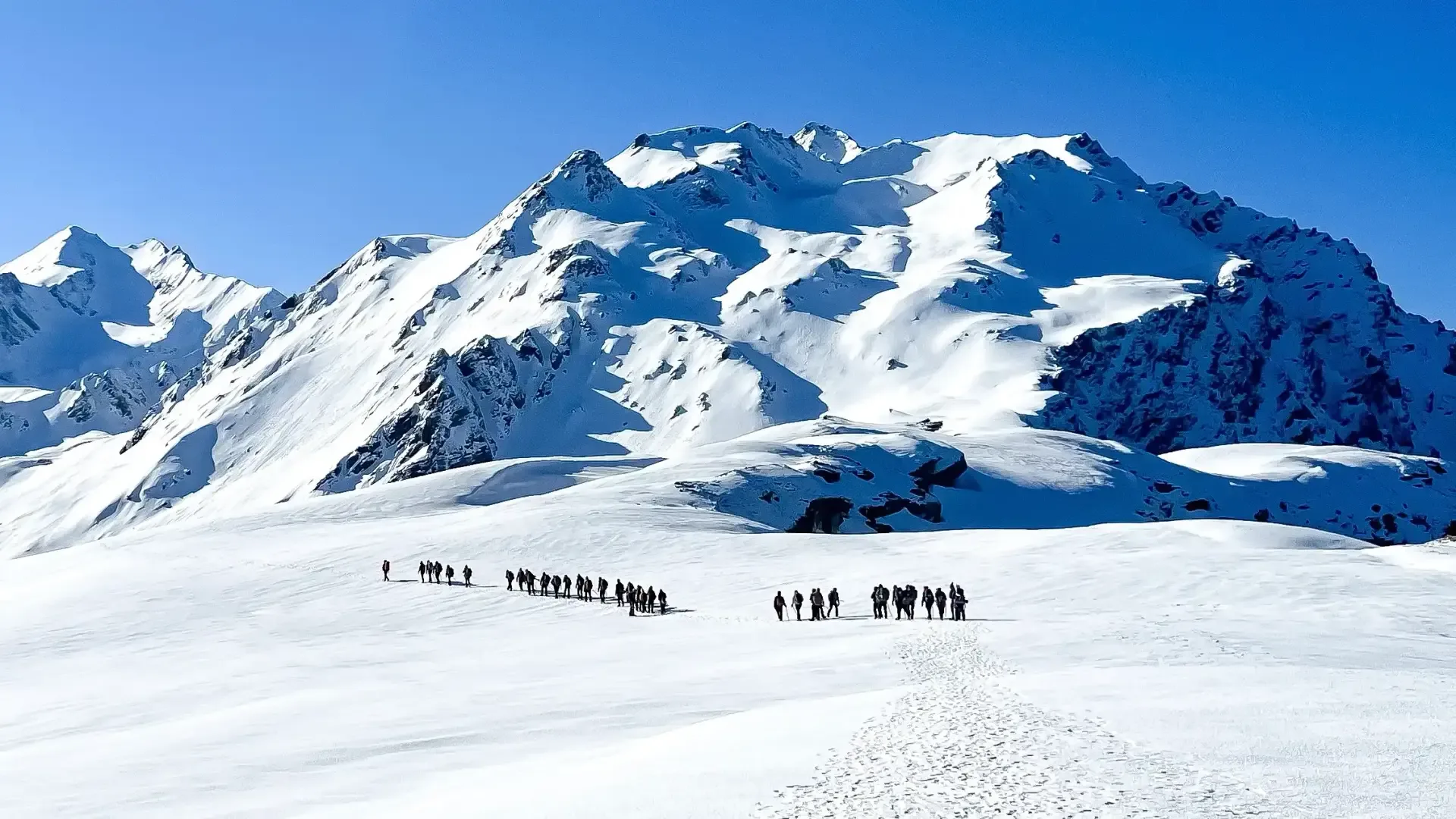
Sar Pass is one of the best-known crossover treks in the Parvati region and has introduced thousands of trekkers to the Himalayas over the past two decades. Beginning from Kasol, the trail climbs through the traditional village of Grahan before entering forests of pine, oak, and rhododendron, eventually opening into broad alpine meadows such as Min Thach and Nagaru.
The expedition culminates with a crossing of Sar Pass at around 13,800 ft, where snowfields often remain well into early summer. Depending on seasonal snow conditions, the descent may include the famous snow slide that has become a hallmark of the trek.
Suitable for fit beginners with proper preparation, Sar Pass offers an excellent combination of changing landscapes, moderate altitude, and classic Himalayan camping.
Quick Facts
Duration
Max Altitude
Difficulty
Best Time
Trek Distance
Trail Atmosphere
Stargazing
Class 2 Dark Sky
Scent Profile
Silence Level
~40 dB
Vertigo Factor
3 / 10
Iconic Spots
Grahan Village
The Sar Pass Crest
Environment
Nature & Culture
Flora & Fauna
Flora
Fauna
Named 'Sar Pass' because trekkers must cross a frozen 'Sar' (small mountain lake) just before the summit ridge. The descent to Biskeri is famous for a dramatic 'snow slide'.
— Local folklore
Spiritual & Cultural Significance
Grahan village has strong local deity protocols (Kaneer/Devta).
🕐 Shrine Timings: Daylight
Temple Protocols
- •Do not touch temple wood
- •Follow strict local entry rules
Technical Details
Challenge & Preparation
Primarily a joint & muscle impact challenge
A capable trekker's route that balances joint & muscle impact and cardio demand.
Personal Readiness
Am I ready?
Planning
Logistics & Trail Intel
Getting There
Route to Base
Kasol is 12 hours by Volvo from Delhi (via Bhuntar), or fly to Bhuntar + 1.5 hour drive
Base Village
Kasol
5,200 ft
Nearest Railhead
Rishikesh
Nearest Airport
Jollygrant Airport
Last ATM
Kasol has 2 ATMs (unreliable). Withdraw in Bhuntar.
Nearest Medical Facility
Kasol PHC / Kullu Hospital
Mobile Signal
Strong signal at Kasol. Good at Grahan village (Airtel/Jio). Zero at Min Thach and across the pass.
Water Sources
Grahan village and Min Thach have reliable piped water from springs. Sar Pass higher camps depend on snow melt and seasonal glacial streams.
Charging
Electricity available at Kasol (Base) and Grahan village. None available beyond Min Thach.
For Drivers
Road Condition
Good road from Bhuntar to Kasol. Prone to traffic jams in May-June.
Bhuntar / Jari
Trail Culinary & Diet
Don't miss the Siddu
Buy specialized diet items at Kasol / Manikaran
The Content & Remote Hub
Top Vlog Spots
Video Calls
base-village-only
Est. 30 Mbps
UPI Reliability
5/10
Base WiFi Available
Permits and Regulations
The trek passes through the GHNP (Great Himalayan National Park) buffer zone. Permits are obtained at the Kasol Forest Check Post or through the registered operator. Indian nationals require a photo ID; foreigners must carry passport copies. GHNP buffer zone rules apply — no littering, no campfires in designated conservation areas. Camping is allowed only at Grahan, Min Thach, Nagaru, and Biskeri Thach. YHAI no longer operates this trek officially; it is now run by private operators.
Learn more about how we vet operators and ensure transparency on our why MountRoutes page.
Packing List
Clothing
- Down jacket (rated -10°C for Nagaru)
- 2 Thermal base layers
- Fleece layer
- Waterproof shell jacket
- Trekking pants (2 pairs)
- Woolen cap and balaclava
- Waterproof gloves
- Woolen socks (3 pairs)
Footwear Gear
- High-ankle waterproof boots
- Microspikes (mandatory May-June)
- Gaiters
- Camp slippers
Gear Safety
- 2 Trekking poles
- Headlamp
- UV400 Sunglasses
- Sunscreen SPF 50+
- Power bank 10000mAh
- 2L Water bottle
- Personal medical kit (Diamox, Kneecaps, ORS)
Deep Dives
Explore Further
Editor's Notes
Sar Pass created more trekkers in India than any other single route. The YHAI era (1990s-2010s) made it the affordable 'gateway drug' to the Himalayas.
The ice slide is the single most memorable moment of any beginner's trekking career. It is 15 seconds of unfiltered, screaming mountain joy.
Explore In Detail
Day by Day Itinerary
5-day route reaching 13,800ft. Covers 42km of varied terrain.
→ See full itinerary with altitude profileDifficulty & Fitness
Rated moderate. Forest (Day 1), steep meadows (Day 2), snow fields (Day 3-4), long forest descent (Day 5). The snow section requires microspikes in May-June.
→ See difficulty breakdown and fitness guideCost & Pricing
Packages range from ₹8,500 – ₹15,500. Inclusions and hidden costs vary by operator tier.
→ See full cost breakdownFrequently Asked Questions
Why is it called "Sar" Pass?
In the local dialect, "Sar" means a lake. You cross a small, often frozen lake near the pass.
Is it good for beginners?
Yes, it is the most popular beginner-friendly pass crossing in the Parvati valley.
What is the snow-slide like?
The descent from the pass is a long, continuous snow-slope where you can slide for hundreds of meters safely.
Where is the base village?
Kasol is the main hub, and the trek typically starts from Barshaini or Grahan.
Are there any cafés on the trail?
Up to Grahan and sometimes near the Nagaru camp, small tea-stalls are available during the peak season.
What is the "Nagaru" campsite?
Nagaru is the highest campsite (12,500 ft) before the pass. It is very windy and offers a great view of the Parvati valley.
Can I see the Parvati peak?
Yes, the Parvati massif and Tosh valley peaks are visible during the higher sections.
What is the best month?
May and June are the best for a proper snow-trek experience.
Route Intelligence
Routes With Similar Character
Routes that share the character of Sar Pass Trek.
Hampta Pass Trek
Both routes are defined by crossing a major Himalayan pass, involving major terrain transitions.
Buran Ghati Trek
Both routes are defined by crossing a major Himalayan pass, involving major terrain transitions.
Chanderkhani Pass Trek
Both routes are defined by crossing a major Himalayan pass, involving major terrain transitions.
Still deciding?
Compare routes side-by-side to find the perfect match for your fitness, dates, and budget.
Everything you need to know, in one place. Someone else in your group needs to see this.
Planning Sar Pass Trek?
Get route conditions, operator updates, and season windows before booking.
Don't miss out! Follow us for route updates@mountroutes|LinkedIn
No spam. Only useful trek updates.
Ready to walk this route?
You’ve read the guide, now find the perfect local team to take you there. Compare our verified list of operators.
Compare verified operators