Explore
Intelligence
Detailed Route
Sar Pass Trek Itinerary — Day by Day Route & Camps
A 5-day immersive expedition traversing diverse Himalayan landscapes and alpine altitudes.
Standard RouteThis is the standard mountain pacing for this trek. Specific operators may add an acclimatization day or alter the starting point. Check individual operator schedules for their exact logistics.
Duration
5 Days
Total Distance
42 KM
Max Altitude
13,800 FT
Trek Type
linear
Day by Day Breakdown
Camp Alt
7,700 ft
Day Gain
+2,500 ft
Arrive Kasol & Trek to Grahan
Homestay or tent stay in Grahan. Evening walk through the village is a cultural highlight. Technical: Steep climb from Kasol valley floor. The trail is well-defined but narrow in places. In monsoon, leeches are active in the lower forest. The last 1 km to Grahan is a gentle flat walk through apple orchards and terraces. Landscape: Grahan is a magical village frozen in time. It has its own goddess — the village Devi — and outsiders are forbidden from touching the temple or its surroundings. The wooden houses are built in the traditional Kath-Kuni style. Many villagers still barter goods. Photography near the temple requires local permission. Safety: Hydrate well. The climb from Kasol is steep and can be dehydrating. Check for leeches after the forest walk (monsoon season).
Key Landmarks
Staying At
The vehicle route broadens into a densely forested river valley environment.
Field Notes
KEY ACTIONRiver Crossings
Plan to cross early in the day before snowmelt swells the water levels. Unclip backpack waist belts before crossing.
Camp Alt
10,800 ft
Day Gain
+3,100 ft
Reach Min Thach
Tent camp. One of the coldest camps on the trek. Sub-zero in May. Technical: The steepest day. You gain over 3,000ft. The trail moves from forest to open meadow. Above 9,000ft, the deodar forest ends and you enter the birch-rhododendron belt. In May-June, snow patches begin above 10,000ft. Microspikes recommended. Landscape: Min Thach is the first 'big meadow' — a vast, flat alpine grazing ground where Gaddi shepherds spend their summers. The views of the Parvati Valley from here are extraordinary. Safety: AMS Zone starts. 10,800ft requires proper hydration. Oximeter check at camp. Rest well tonight — summit push is tomorrow.
Key Landmarks
Staying At
The trail follows the mountain river corridor through a narrow, forested gorge, moving past traditional settlements into increasingly dense dense forested valleys.
Camp Alt
12,500 ft
Day Gain
+1,700 ft
Reach Nagaru
This is the highest camp before the pass. Wind can rattle tents all night. Earplugs recommended. Technical: The trail enters deep snow in May-June. Navigation is by cairns and guide markers. Nagaru is an exposed ridge camp — wind speeds can be extreme. Set up camp in the sheltered hollow below the ridge. Landscape: Nagaru feels like the edge of the world. You are camping on a ridge with the Parvati Valley on one side and the Sainj Valley on the other. On clear evenings, you can see the lights of Kullu town far below. Safety: Critical AMS check. 12,500ft is serious altitude. Do not overexert. Early dinner, early sleep. Summit briefing at 6 PM.
Key Landmarks
Staying At
Tree line disappears as the valley broadens into a spectacular high-altitude alpine meadow basin, replacing the dense forests with expansive grazing pastures.
Camp Alt
11,500 ft
Day Gain
-1,000 ft
Today's Objective
🏔 Cross Sar Pass
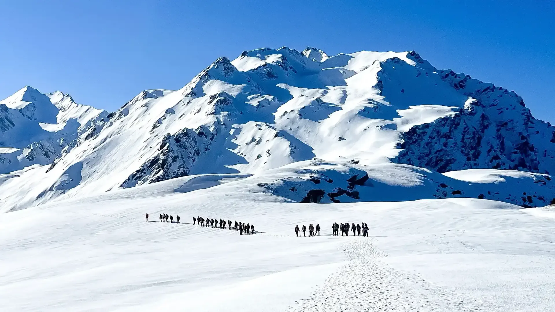
Biskeri Thach is one of the most beautiful meadows in Himachal. Celebration camp tonight. Technical: Start at 5 AM. The ascent to the pass is a 3-hour snow walk — steady but not technical. The pass crest offers a stunning 360-degree view of the Parvati and Sainj valleys. The descent on the far side features the legendary 'Ice Slide' — a 150m snow chute where you slide down on your back (guide assists). Exhilarating but safe. The remaining descent to Biskeri Thach is through melting snow and meadows. Landscape: The ice slide is the single most talked-about moment of Sar Pass. Veterans describe it as '10 seconds of pure adrenaline followed by 10 minutes of laughing'. It is safe, controlled, and supervised by guides — but the sensation of sliding down a Himalayan snow face is primal. Safety: Turnback time: 11 AM. Snow softens dangerously after noon. Listen to the guide on the ice slide — sit down, cross arms, and lean back. Do NOT stand up mid-slide.
Key Landmarks
Staying At
The route crosses the pass crest, crossing a high-altitude snow ridge into the Sainj valley.
Camp Alt
6,500 ft
Day Gain
-5,000 ft
Descend to Barshaini
Trek ends at Barshaini. Drive to Kasol (30 mins) or Bhuntar (1 hour). Technical: Long, sustained descent. Hard on the knees. The trail passes through thick forest — leech risk in monsoon. Reach Barshaini by 3 PM for drive back to Kasol/Bhuntar. Safety: Knee Fatigue. Use poles. Break every 45 minutes.
Key Landmarks
The alpine meadows drop rapidly back into a thick, humid forest environment.
Trek Extensions & Add-ons
Biskeri Thach Rest Day
+1 DayExtra day at the beautiful Biskeri campsite for photography of the snow-clad peaks.
Plan Your Trek:
Ready to book? Compare verified operators for Sar Pass Trek — transparent pricing, no paid rankings.
Still deciding?
Compare routes side-by-side to find the perfect match for your fitness, dates, and budget.
Day by day, camp by camp. Send this to your group so everyone's on the same page.
Step 4: Cost & Logistics
You understand the route.
Now see what services, permits, and logistics actually cost.
View Cost Breakdown