
Explore
Intelligence
Essential Planning Guide
Rohini Bugyal Trek — Complete Guide (2026)
Vibe & Scenery
The Experience
Introduction
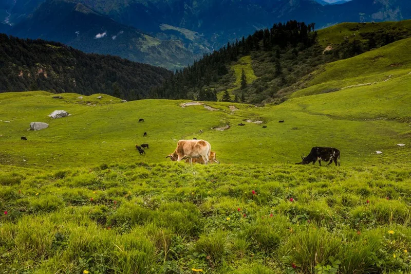
Rohini Bugyal offers a quieter perspective on one of Garhwal's most popular trekking regions. Rohini Bugyal itself lies at around 8,900 ft, while itineraries that continue towards Tungnath and Chandrashila reach approximately 13,100 ft. While most visitors head directly towards the summits, this route spends more time exploring the tranquil forests and meadows that surround them.
The trail passes through the Kedarnath Wildlife Sanctuary, where ancient oak, rhododendron, and maple forests provide excellent opportunities for birdwatching and wildlife observation. During spring, blooming rhododendrons transform large sections of the forest into vibrant shades of red and pink before the trail opens onto peaceful alpine meadows.
Throughout the journey, clear views extend towards Chaukhamba, Kedar Dome, Nilkantha, and neighbouring Garhwal peaks. Whether completed as a standalone meadow trek or combined with Tungnath and Chandrashila, Rohini Bugyal offers a far more tranquil experience than the region's heavily visited summit trails.
Quick Facts
Duration
Max Altitude
Difficulty
Best Time
Trek Distance
Trail Atmosphere
Stargazing
Class 2 Dark Sky
Scent Profile
Silence Level
~30 dB
Vertigo Factor
4 / 10
Iconic Spots
Deoria Tal Reflection
Chandrashila Summit
Environment
Nature & Culture
Flora & Fauna
Flora
Fauna
Tungnath is the Third Kedar. According to legend, the arms of Lord Shiva appeared here after he took the form of a bull to avoid the Pandavas. Chandrashila is where Lord Rama is said to have meditated after defeating Ravana.
— Local folklore
Spiritual & Cultural Significance
Extremely high. Tungnath is one of the Panch Kedar, deeply revered by Hindus.
🕐 Shrine Timings: Tungnath temple opens in summer and closes in winter (the idol is moved to Ukhimath). Even when closed, the architecture and aura are stunning.
Temple Protocols
- •Remove shoes before entering the Tungnath courtyard.
- •Dress modestly.
- •Strict vegetarian area.
Festivals & Dates
Technical Details
Challenge & Preparation
Primarily a cardio demand challenge
A capable trekker's route that balances cardio demand and altitude exposure.
Personal Readiness
Am I ready?
Planning
Logistics & Trail Intel
Getting There
Route to Base
Arrive in Rishikesh or Haridwar by train/bus
From there, take a shared cab or private taxi for the 7-hour drive along the Alaknanda/Mandakini valleys to Sari
Base Village
Sari
6,600 ft
Last ATM
Ukhimath (15 km before Sari). Do not rely on ATMs at Chopta or Sari.
Nearest Medical Facility
Primary Health Center in Ukhimath / District Hospital in Rudraprayag.
Mobile Signal
Dead zones in the forest and at the summit. Patchy in Chopta.
Water Sources
Streams are frequent until Rohini Bugyal. From Chopta to the summit, there are ZERO water sources. Carry 2L minimum.
Charging
Some guesthouses in Sari and Chopta (solar powered). Unreliable. Carry a power bank.
For Drivers
Road Condition
Good highways up to Rudraprayag. The mountain road from Ukhimath to Sari/Chopta is narrow and can be blocked by heavy snow in winter.
Ukhimath
Trail Culinary & Diet
Don't miss the Pahadi Rajma Chawal.
Buy specialized diet items at Rishikesh. Expect very basic Indian vegetarian food on the mountain.
The Content & Remote Hub
No DronesStrictly banned without permits, as it is a protected Wildlife Sanctuary.Top Vlog Spots
Video Calls
low
Est. 2 Mbps
UPI Reliability
4/10
Permits and Regulations
The trek lies within the Kedarnath Wildlife Sanctuary. Entry permits are mandatory and are usually obtained at the forest check post in Sari Village or Chopta. Due to massive ecological strain, the forest department has enforced strict 'Leave No Trace' policies. Plastic bottles are highly regulated, and camping right next to Deoria Tal is illegal. Trekkers must use designated eco-campsites.
Learn more about how we vet operators and ensure transparency on our why MountRoutes page.
Packing List
Trekking Clothing
- Heavy down jacket (temperatures at Chopta/Chandrashila drop below freezing)
- Windproof and waterproof hardshell jacket
- 2 pairs of comfortable trekking pants (avoid jeans)
- 3 thermal baselayers (merino wool or synthetic)
- Fleece pullover or mid-layer
- Warm woolen beanie and UV-protective sun hat
- 4 pairs of thick woolen trekking socks
Footwear & Gear
- High-ankle waterproof trekking boots with deep tread
- Microspikes and gaiters (mandatory for Chandrashila in early spring/late autumn)
- 2 anti-shock trekking poles (crucial for the steep descent from Chandrashila)
- 40L-50L backpack with rain cover
- Headlamp with spare batteries (needed for the pre-dawn summit push)
Health & Utilities
- Category 4 UV Polarized sunglasses (snow blindness risk on summit)
- Comprehensive First Aid Kit (Diamox, blister tape, muscle rub)
- High SPF Sunscreen (50+) and lip balm
- 2 reusable 1-liter water bottles or a hydration bladder
- Heavy-duty power bank
- Toilet kit with biodegradable wipes
Deep Dives
Explore Further
Editor's Notes
Explore In Detail
Day by Day Itinerary
6-day route reaching 13,100ft. Covers 27.0km of varied terrain.
→ See full itinerary with altitude profileDifficulty & Fitness
Rated moderate. The trail to Rohini Bugyal is a classic forest walk with roots, rocks, and mud. The final ascent to Chandrashila is steep, exposed rock (or deep snow in winter).
→ See difficulty breakdown and fitness guideCost & Pricing
Packages range from ₹8,500 – ₹12,000. Inclusions and hidden costs vary by operator tier.
→ See full cost breakdownFrequently Asked Questions
How difficult is the Rohini Bugyal and Chandrashila trek?
The trek from Sari to Rohini Bugyal to Chopta is graded Easy-to-Moderate. However, the final summit day from Chopta to Chandrashila (13,100 ft) is a steep, demanding climb that requires good cardiovascular fitness.
Is there water available on the trail?
Yes, there are several mountain streams between Deoria Tal and Rohini Bugyal. However, there are no natural water sources on the final climb from Tungnath to Chandrashila.
Will we see the rhododendron blooms?
If you trek between late March and early May, the forests between Deoria Tal and Rohini Bugyal are ablaze with red, pink, and white rhododendron (Buransh) flowers.
Is this trek safe for beginners?
Yes, it is highly recommended for beginners. The altitude gain is gradual over the first few days, which aids acclimatization before the high push to Chandrashila.
Are there leeches on the trail?
During the monsoon season (July and August), the forest section between Deoria Tal and Rohini Bugyal is heavily infested with leeches. We do not recommend trekking during these months.
Do I need technical climbing gear for Chandrashila?
No. Chandrashila is a trekking peak. However, if you trek in winter or early spring (December to April), the trail is covered in snow, making microspikes and trekking poles absolutely mandatory.
Is mobile network available?
Network is patchy. You will get BSNL/Jio signals at Sari village and parts of Deoria Tal and Chopta, but expect no network at Rohini Bugyal or on the trail.
Can I camp at Deoria Tal?
Recent forest department regulations strictly prohibit camping directly on the shores of Deoria Tal. Campsites are now set up in designated clearings slightly away from the lake to protect the ecosystem.
Still deciding?
Compare routes side-by-side to find the perfect match for your fitness, dates, and budget.
Everything you need to know, in one place. Someone else in your group needs to see this.
Planning Rohini Bugyal Trek?
Get route conditions, operator updates, and season windows before booking.
Don't miss out! Follow us for route updates@mountroutes|LinkedIn
No spam. Only useful trek updates.
Ready to walk this route?
You’ve read the guide, now find the perfect local team to take you there. Compare our verified list of operators.
Compare verified operators