
Explore
Intelligence
Detailed Route
Masar Tal Trek Itinerary — Day by Day Route & Camps
A 10-day round trip from Ghuttu, traversing isolated villages and dense forests before establishing a high camp to push for the 13,580 ft alpine lake.
Standard RouteThis is the standard mountain pacing for this trek. Specific operators may add an acclimatization day or alter the starting point. Check individual operator schedules for their exact logistics.
Duration
10 Days
Total Distance
108.0 KM
Max Altitude
13,580 FT
Trek Type
circuit
Permits Required Before You Go
Permit Cost
Where to Get
Forest Checkpost in Ghuttu
Documents
Aadhar Card / Passport, Medical Fitness Certificate
Foreign Nationals
Standard forest entry fees apply, often slightly higher. No complex Inner Line Permits required as it is not an immediate border zone.
Foreigner Process
Standard forest entry permits required. Handled easily at the Ghuttu checkpost by the agency.
Nearest Embassy Hub
New Delhi
Day by Day Breakdown
Camp Alt
5,000 ft
Day Gain
+3,900 ft
Drive to Ghuttu
A scenic drive along the Bhagirathi and Bhilangana rivers. Ghuttu is a quiet, traditional Garhwali town that serves as the basecamp and administrative hub for the Khatling region. Rest and finalize permits.
Key Landmarks
Staying At
The motorable road navigates deeper into the mountain river corridor, where the landscape transitions from lower foothills into the steep, dense forested valleys.
Camp Alt
8,500 ft
Day Gain
+3,500 ft
Reach Reeh
The trek begins with a steep, demanding ascent right out of Ghuttu. You climb through dense pine and oak forests, occasionally passing small, terraced farms. The campsite at Reeh offers the first commanding views of the valley below.
Key Landmarks
Staying At
The route moves through forested zones. The path breaches the mountain barrier crossing the watershed.
Camp Alt
9,500 ft
Day Gain
+1,000 ft
Reach Gangi
A relatively easier, undulating day. The trail traverses the mountainside before arriving at Gangi, one of the most remote and culturally fascinating villages in Uttarakhand. The wooden architecture and traditional lifestyle here have remained largely unchanged for centuries.
Key Landmarks
Staying At
The trail follows the mountain river corridor through a narrow, forested gorge, moving past traditional settlements into increasingly dense dense forested valleys.
Camp Alt
11,000 ft
Day Gain
+1,500 ft
Reach Kharsoli
You leave civilization completely behind. The trail dips down to the Bhilangana river, crossing side streams and dense mixed forests. The path can be broken and slippery in sections. Kharsoli is a beautiful clearing surrounded by birch trees (Bhojpatra).
Key Landmarks
Staying At
The route moves through forested zones. The route follows the river valley.
Field Notes
KEY ACTIONHelmet Mandatory
Helmet mandatory. Move quickly and quietly through the rockfall zone without stopping to rest.
Use Trekking Poles
Trekking poles are highly recommended to save your knees on the descent.
INFOSlower Progress
Progress will be significantly slower and more taxing on your ankles than trail distance suggests.
Camp Alt
12,000 ft
Day Gain
+1,000 ft
Reach Tambakund
The landscape undergoes a dramatic alpine shift. The trees disappear, replaced by vast, sweeping meadows and eventually glacial moraine. As you approach Tambakund, the massive snout of the Khatling Glacier comes into view. You establish your advanced base camp here.
Key Landmarks
Staying At
The environment transitions into open alpine meadows. The valley transitions into a glacial basin.
Field Notes
Use Trekking Poles
Trekking poles are highly recommended to save your knees on the descent.
INFOSlower Progress
Progress will be significantly slower and more taxing on your ankles than trail distance suggests.
Camp Alt
13,580 ft
Day Gain
+1,580 ft
Today's Objective
💧 Reach Tambakund
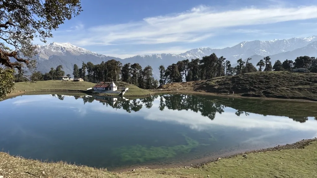
The objective day. You leave the valley floor and begin a steep, grueling climb up the lateral moraine east of the Khatling Glacier. The trail is loose rock and scree. Upon conquering the ridge, Masar Tal reveals itself—a stunning, high-altitude alpine lake locked in a rocky bowl.
Key Landmarks
Staying At
The valley transitions into a glacial basin. The route ascends to an exposed ridge line.
Field Notes
KEY ACTIONHelmet Mandatory
Helmet mandatory. Move quickly and quietly through the rockfall zone without stopping to rest.
Stow Poles
Requires hands-on rock scrambling. Stow trekking poles to free up your hands.
INFOSlower Progress
Progress will be significantly slower and more taxing on your ankles than trail distance suggests.
Camp Alt
11,000 ft
Day Gain
-2,580 ft
Trek to Kharsoli
A massive descent day. You carefully navigate down the steep scree slopes back to Tambakund, and then continue the long march down the valley past the meadows to reach the tree line at Kharsoli.
Key Landmarks
Staying At
The trail follows the mountain river corridor through a narrow, forested gorge, moving past traditional settlements into increasingly dense dense forested valleys.
Field Notes
Use Trekking Poles
Trekking poles are highly recommended to save your knees on the descent.
INFOSlower Progress
Progress will be significantly slower and more taxing on your ankles than trail distance suggests.
Camp Alt
8,500 ft
Day Gain
-2,500 ft
Trek to Reeh
A very long walking day, effectively combining the ascent of Days 3 and 4 into a single descent. You push past Gangi village and re-enter the deep pine forests, dropping significantly in altitude.
Key Landmarks
Staying At
The trail follows the mountain river corridor through a narrow, forested gorge, moving past traditional settlements into increasingly dense dense forested valleys.
Camp Alt
5,000 ft
Day Gain
-3,500 ft
Trek to Ghuttu
The final morning is a rapid, steep descent through the oak and pine forest back down to the roadhead at Ghuttu, marking the end of the trekking portion.
Key Landmarks
Staying At
The trail follows the mountain river corridor through a narrow, forested gorge, moving past traditional settlements into increasingly dense dense forested valleys.
Camp Alt
1,100 ft
Day Gain
-3,900 ft
Drive to Rishikesh
Board your vehicles for the scenic drive back to Rishikesh, officially ending the expedition.
Key Landmarks
The mountain valley topography transitions back into the lower foothill river plains.
Trek Extensions & Add-ons
Mayali Pass & Kedarnath Extreme Crossover
+4 DaysFrom Masar Tal, cross the technical Mayali Pass (16,400 ft) to Vasuki Tal, and descend into the Kedarnath shrine. This converts the trek into a hardcore mountaineering expedition.
Plan Your Trek:
Ready to book? Compare verified operators for Masar Tal Trek — transparent pricing, no paid rankings.
Still deciding?
Compare routes side-by-side to find the perfect match for your fitness, dates, and budget.
Day by day, camp by camp. Send this to your group so everyone's on the same page.
Step 4: Cost & Logistics
You understand the route.
Now see what services, permits, and logistics actually cost.
View Cost Breakdown