
Explore
Intelligence
Essential Planning Guide
Masar Tal Trek — Complete Guide (2026)
Vibe & Scenery
The Experience
Introduction
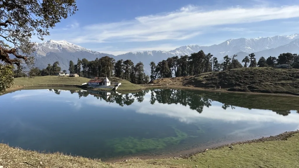
Hidden above the Bhilangna Valley, Masar Tal is a pristine glacial lake that serves both as an independent trekking objective and as an important campsite for expeditions crossing Mayali Pass. Although overshadowed by the famous crossover, the lake itself rewards trekkers with dramatic alpine scenery and remarkable solitude.
Beginning from the remote village of Gangi, the trail climbs through pine and birch forests before entering increasingly rugged terrain shaped by the nearby Khatling Glacier. Boulder fields, alpine meadows, and glacial streams characterize the upper valley before reaching the lake.
Suitable for experienced trekkers, Masar Tal offers a rewarding expedition into one of Garhwal's quieter high-altitude landscapes.
Quick Facts
Duration
Max Altitude
Difficulty
Best Time
Trek Distance
Trail Atmosphere
Stargazing
Class 1 Dark Sky
Scent Profile
Silence Level
~10 dB
Vertigo Factor
4 / 10
Iconic Spots
Masar Tal
Khatling Glacier Snout
Gangi Village
Environment
Nature & Culture
Flora & Fauna
Flora
Fauna
The Bhilangana river originates from the Khatling glacier. The region is steeped in Shiva mythology, acting as the ancient, perilous backdoor route to the Kedarnath shrine via the Mayali Pass.
— Local folklore
Spiritual & Cultural Significance
The trail is a historic, perilous pilgrimage route leading toward Kedarnath. The waters and peaks are deeply revered by the locals of Gangi.
🕐 Shrine Timings: N/A
Temple Protocols
- •Maintain strict silence and reverence near the lake.
- •Do not wash clothes or utensils in Masar Tal.
Technical Details
Challenge & Preparation
Primarily a cardio demand and cumulative fatigue challenge
A demanding expedition with extreme cardio demand and cumulative fatigue.
Personal Readiness
Am I ready?
Planning
Logistics & Trail Intel
Getting There
Route to Base
Take a train or fly to Dehradun/Rishikesh
From Rishikesh, drive 160 km (approx 7 hours) via Tehri Dam to reach Ghuttu
Base Village
Ghuttu
5,000 ft
Last ATM
Tehri / Ghansali (Draw cash before reaching Ghuttu)
Nearest Medical Facility
Primary Health Centre (PHC) in Ghuttu. District Hospital in Tehri.
Mobile Signal
Total blackout.
Water Sources
Rivers and glacial streams. Water near Khatling is heavy with glacial silt; let it settle, then filter and purify before drinking.
Charging
Total blackout from Ghuttu onward.
For Drivers
Road Condition
The drive from Rishikesh via Tehri is mostly on good paved roads, narrowing significantly as you approach Ghuttu.
Tehri / Ghansali
Trail Culinary & Diet
Don't miss the Garhwali Dal and Rice
Buy specialized diet items at Rishikesh / Tehri
The Content & Remote Hub
No DronesGenerally prohibited without explicit forest department permission in the upper Khatling biosphere.Top Vlog Spots
Video Calls
none
Est. 0 Mbps
UPI Reliability
2/10
Permits and Regulations
Forest department permits are required for the Bhilangana valley and Khatling region. These are typically arranged by your trekking operator at the forest check-post in Ghuttu.
Learn more about how we vet operators and ensure transparency on our why MountRoutes page.
Packing List
Core Extreme Clothing Layers
- Heavyweight Down Jacket (rated to -10°C)
- Waterproof/Windproof Gore-Tex outer shell (jacket and pants)
- Thermal Merino wool base layers (x2 sets)
- Thick fleece mid-layers
Footwear & Protection
- Rigid, high-ankle expedition trekking boots
- Thick Merino wool socks (x4 pairs)
- High-altitude waterproof gaiters (for snow near the lake)
- Microspikes (for early season ice near Tambakund)
Head & Hands
- Fleece balaclava and heavy winter beanie
- Category 4 polarized glacier glasses
- Waterproof insulated outer gloves
- Thin fleece inner liner gloves
Gear & Accessories
- 60-70 litre expedition backpack with rain cover
- Heavy-duty trekking poles (essential for moraine navigation)
- Four-season sleeping bag (rated to -15°C)
- Comprehensive first aid kit with Diamox
- Water purification tablets/Lifestraw
Deep Dives
Explore Further
Editor's Notes
Explore In Detail
Day by Day Itinerary
10-day route reaching 13,580ft. Covers 108.0km of varied terrain.
→ See full itinerary with altitude profileDifficulty & Fitness
Rated challenging. The route shifts from dense, humid forests with steep dirt trails to highly unstable glacial moraine and boulder fields above 12,000 ft.
→ See difficulty breakdown and fitness guideCost & Pricing
Packages range from 18,000 - 24,000 INR. Inclusions and hidden costs vary by operator tier.
→ See full cost breakdownFrequently Asked Questions
Is this trek suitable for beginners?
No. The trek requires high physical endurance. The trail beyond Gangi becomes progressively rugged, transitioning into steep, loose scree and glacial moraine near Tambakund and Masar Tal.
Do I cross the Khatling Glacier on this trek?
To reach Masar Tal, you trek parallel to and slightly above the Khatling Glacier snout. You will navigate its lateral moraine, but you do not do a full glacier traverse unless you are continuing to Mayali Pass.
Are there any villages or homestays on the route?
Gangi (Day 3) is the last inhabited village on the trail. It is one of the most remote villages in Garhwal. Beyond Gangi, you must rely entirely on expedition camping.
Do I need a local guide?
Yes, it is highly recommended. The trail between Kharsoli and Tambakund frequently washes out or changes due to landslides and glacial shift. A local guide from Ghuttu or Gangi is essential.
What is the risk of AMS?
Moderate to High. You will sleep at 12,000 ft (Tambakund) and push to nearly 13,600 ft (Masar Tal). The itinerary builds in gradual ascent, but symptoms must be monitored closely.
Can I continue to Kedarnath from Masar Tal?
Yes, but this transforms the trek into a highly technical mountaineering expedition over Mayali Pass (16,400 ft) and requires ropes, ice axes, and a specialized crew. This itinerary covers Masar Tal as the final objective.
Is there mobile connectivity?
You will lose all network coverage shortly after leaving Ghuttu. The trek is a complete digital detox.
What kind of wildlife might we encounter?
The dense forests around Reeh and Gangi are home to Himalayan Black Bears and leopards. Higher up, Bharal (Blue Sheep) and Monal pheasants are common.
Still deciding?
Compare routes side-by-side to find the perfect match for your fitness, dates, and budget.
Everything you need to know, in one place. Someone else in your group needs to see this.
Planning Masar Tal Trek?
Get route conditions, operator updates, and season windows before booking.
Don't miss out! Follow us for route updates@mountroutes|LinkedIn
No spam. Only useful trek updates.
Ready to walk this route?
You’ve read the guide, now find the perfect local team to take you there. Compare our verified list of operators.
Compare verified operators