Essential Planning Guide
Krishna Temple Yulla Kanda Trek — Complete Guide (2026)
Introduction
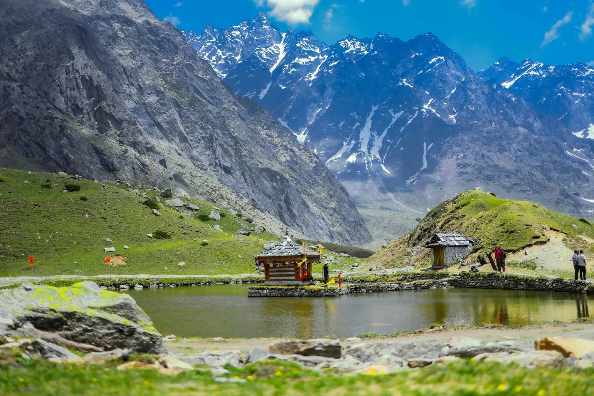
The Yulla Kanda trek takes you to the world's highest Krishna Temple, located in the middle of a stunning alpine lake in the remote Kinnaur district of Himachal Pradesh. Starting from the traditional village of Yulla Khas (near Tapri), the trail ascends rapidly through thick forests of pine, oak, and cedar before opening up into vast, pristine meadows. At an altitude of 12,779 feet, the holy lake provides a serene reflection of the surrounding Kinner Kailash range. Every year during Janmashtami, locals from neighboring villages hike up to the lake to celebrate the festival. This is a moderate, short trek that offers a perfect blend of rich Kinnauri culture, deep mythology, and spectacular high-altitude wilderness.
Ready to book? Compare verified operators for Krishna Temple Yulla Kanda Trek — transparent pricing, no paid rankings.
Quick Facts
Duration
Max Altitude
Difficulty
Best Time
Trek Distance
Trail Atmosphere
Stargazing
Class 1 Dark Sky
Scent Profile
Silence Level
~8 dB
Vertigo Factor
2 / 10
Primarily a joint & muscle impact and altitude exposure challenge
A capable trekker's route that balances joint & muscle impact and altitude exposure.
Iconic Spots
Deo Tibba Panorama from Yulla Kanda Ridge
The Ancient Temple at 13,800 ft
Getting There
Route to Base
Taxi from Manali (45 mins) or local bus from Kinnaur to Yulla Khas
Old Manali-Kinnaur highway via left bank of Beas
Base Village
Yulla Khas (Kinnaur)
8,900 ft
Last ATM
Manali
Nearest Medical Facility
Manali Civil Hospital
Mobile Signal
Yulla Khas has 4G. Drops to zero above the forest.
Water Sources
Good springs up to 11,000 ft. Carry 2L from last spring for upper ridge section.
Charging
Yulla Khas only.
For Drivers
Road Condition
Old Manali road to Yulla Khas is well-maintained, slightly narrow. Yulla Khas is easily accessible by taxi from Manali.
Manali
Trail Culinary & Diet
Don't miss the Aktori (buckwheat pancakes) and Siddu with ghee available at Yulla Khas homestays
Buy specialized diet items at Manali (full range of cafes and health food options)
The Content & Remote Hub
Top Vlog Spots
Video Calls
none
Est. 0 Mbps
UPI Reliability
3/10
Base WiFi Available
The Kinnaur Temple Network
Key point
The Krishna temple at Yulla Kanda is part of an ancient network of high ridge shrines called 'Dev Sthans' maintained by the Kinnaur valley's 365 local deities. Each deity has a specific high mountain home — Yulla Kanda is Krishna's summer abode.
Explore In Detail
Day by Day Itinerary
4-day route reaching 13,800ft. Covers 25km of varied terrain.
→ See full itinerary with altitude profileDifficulty & Fitness
Rated moderate. Good trail through forest, transitioning to open grassy ridge. No technical terrain. Steepness is the main challenge.
→ See difficulty breakdown and fitness guideCost & Pricing
Packages range from ₹4,500 - ₹9,500. Inclusions and hidden costs vary by operator tier.
→ See full cost breakdownPermits and Regulations
No formal trekking permit required. Temple dress code must be respected. No alcohol or meat near the shrine. Camping at the ridge meadow is locally accepted.
Learn more about how we vet operators and ensure transparency on our why MountRoutes page.
Packing List
Spiritual Etiquette Essentials
- Modest, non-revealing clothing (temple protocols require covered shoulders and legs at the shrine)
- Small offering items — flowers, incense, sweets (available in Yulla Khas bazaar)
High Ridge Gear
- Wind-stopper outer layer (the Yulla Kanda ridge is notoriously exposed and windy year-round)
- Trekking poles (steep descent on grassy slopes is slippery when wet)
- Warm hat and gloves (wind chill at 13,800 ft is extreme even in September)
Camera & Documentation
- Wide-angle lens for the full Deo Tibba panorama
- Extra batteries (cold drains batteries rapidly)
Flora & Fauna
Flora
Fauna
According to Kinnaur valley tradition, Lord Krishna spent a summer on the Yulla Kanda ridge during one of his divine wanderings. The temple marks the exact spot where he is said to have rested and played his flute, causing all the birds and animals of the valley to gather below.
— Local folklore
Spiritual & Cultural Significance
Active Krishna temple maintained by local Kinnaur valley devotees. One of the highest Krishna shrines in India.
🕐 Shrine Timings: No fixed timings. Temple open when priest is present (Jun-Oct).
Temple Protocols
- •Covered shoulders and legs mandatory
- •No shoes inside or near the shrine
- •No photography of the deity idol without permission
Festivals & Dates
Frequently Asked Questions
Who visits this temple normally?
Local Kinnaur valley villagers make an annual pilgrimage to the Krishna temple at Yulla Kanda during a specific festival in August. Outside this festival, the trail is nearly empty.
Is this a religious site — can non-Hindus visit?
Yes. The temple is open to all visitors who approach with respect. Modest dress and no smoking/drinking near the shrine are expected.
What are the views like from the top?
Extraordinary. From the Yulla Kanda ridge, you can see Deo Tibba (21,340 ft), the entire Kinnaur valley, the Pir Panjal range, and on extremely clear days, the distant Zanskar peaks.
Can I do this as a day hike from Manali?
Technically possible but brutal. The round trip is 22+ km with 6,500 ft of combined gain/loss. An overnight camp on the ridge is highly recommended.
Is there water on the trail?
Good water sources exist up to 11,000 ft. The upper ridge section is dry — carry at least 2 liters from the last spring before the final ascent.
Is a guide necessary?
Recommended. The upper trail above the forest is faint and poorly marked. Local Yulla Khas-based guides know the exact line to the ridge.
What is the August festival?
A traditional Kinnaur valley deity procession (Devta Yatra) accompanies a large pilgrimage to the temple. It is one of the most authentic high-altitude festival experiences in Himachal.
Can I camp near the temple?
Yes. Camping is permitted at the meadow just below the temple. The ridge makes for an extraordinary stargazing experience.
What is Yulla Khas like as a base?
Yulla Khas is a historic town with the famous Yulla Khas Castle (now a heritage hotel), the Nicholas Roerich Museum, and a thriving arts community. It is a far quieter and more authentic base than Manali.
How far is Yulla Khas from Manali?
Approximately 22 km south of Manali on the old Kinnaur-Manali road. 45 minutes by taxi.
Other Treks Guides
Still deciding?
Compare routes side-by-side to find the perfect match for your fitness, dates, and budget.
Everything you need to know, in one place. Someone else in your group needs to see this.
Planning Krishna Temple Yulla Kanda Trek?
Get route conditions, operator updates, and season windows before booking.
No spam. Only useful updates.
Ready to walk this route?
You’ve read the guide, now find the perfect local team to take you there. Compare our verified list of operators.
Compare verified operators