Explore
Intelligence
Detailed Route
Gaumukh Tapovan Trek Itinerary — Day by Day Route & Camps
An 8-day iconic expedition following the Bhagirathi River from Gangotri to the high-altitude meadows of Tapovan.
Standard RouteThis is the standard mountain pacing for this trek. Specific operators may add an acclimatization day or alter the starting point. Check individual operator schedules for their exact logistics.
Duration
8 Days
Total Distance
48 KM
Max Altitude
14,600 FT
Trek Type
circuit
Day by Day Breakdown
Camp Alt
10,200 ft
Day Gain
+8,100 ft
Drive to Gangotri
Pick up from Dehradun at 6:00 AM. Long drive into the deep Garhwal. Harsil is a famous stop for its apple orchards. Gangotri is a holy town at 10,200ft. Night stay in a hotel. First stage of acclimatization is critical here.
Key Landmarks
The urban environment of Dehradun is replaced by deep river valleys and dense pine forests. The drive introduces the high-altitude temple town of Gangotri.
Camp Alt
10,200 ft
Day Gain
0 ft
Today's Objective
☕ Acclimatization & Recovery
Short hike to Surya Kund and Pandav Gufa (3km). Visit the evening Aarti at the temple. Drink plenty of water. This day helps prevent AMS on the steep climb to Bhojbasa.
Key Landmarks
The environment remains centered around the dense, active settlement of Gangotri and the immediate river gorge.
Camp Alt
11,811 ft
Day Gain
+1,611 ft
Reach Chirbasa
Trek begins at the forest check-post. The trail follows the Bhagirathi river upstream. Gradual uphill on a well-marked path. Chirbasa (meaning 'Home of Pines') is a scenic campsite with clear views of the Bhagirathi peaks.
Key Landmarks
Staying At
The settlement of Gangotri gives way to dense pine (Chir) forests. The valley provides the first clear views of the Sudershan and Bhagirathi peaks.
Field Notes
KEY ACTIONRiver Crossings
Plan to cross early in the day before snowmelt swells the water levels. Unclip backpack waist belts before crossing.
Camp Alt
12,450 ft
Day Gain
+639 ft
Reach Bhojbasa
A shorter trek to aid acclimatization. Terrain becomes more rocky and barren as you exit the tree line. Bhojbasa is the last forest department outpost. Night stay in tents or the GMVN guesthouse.
Key Landmarks
Staying At
The pine forests disappear entirely, replaced by sparse birch (Bhojpatra) trees and a rocky, barren landscape. The valley widens significantly, revealing the first views of Mt. Shivling.
Field Notes
KEY ACTIONHelmet Mandatory
Helmet mandatory. Move quickly and quietly through the rockfall zone without stopping to rest.
KEY ACTIONRiver Crossings
Plan to cross early in the day before snowmelt swells the water levels. Unclip backpack waist belts before crossing.
Use Trekking Poles
Trekking poles are highly recommended to save your knees on the descent.
INFOSlower Progress
Progress will be significantly slower and more taxing on your ankles than trail distance suggests.
Camp Alt
14,600 ft
Day Gain
+2,150 ft
Today's Objective
🏔 Summit Tapovan
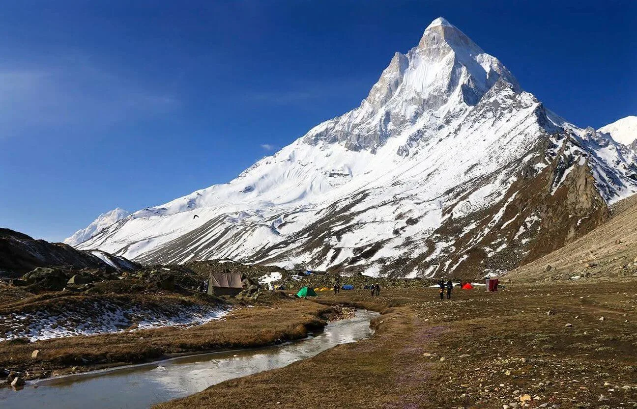
Trek to Gaumukh (4km), the source of Ganga. From there, cross the Gangotri glacier moraine. The final climb to Tapovan is a steep 2km ascent on rocks and scree. Tapovan is a high-altitude meadow at the very foot of Mt. Shivling. Most beautiful campsite in the Himalayas.
Key Landmarks
Staying At
The rocky valley floor narrows into a fractured glacier environment. Reaching Tapovan introduces a high-altitude alpine meadow directly beneath the south face of Mt. Shivling.
Field Notes
KEY ACTIONRiver Crossings
Plan to cross early in the day before snowmelt swells the water levels. Unclip backpack waist belts before crossing.
Stow Poles
Requires hands-on rock scrambling. Stow trekking poles to free up your hands.
INFOSlower Progress
Progress will be significantly slower and more taxing on your ankles than trail distance suggests.
Camp Alt
14,600 ft
Day Gain
0 ft
Today's Objective
☕ Acclimatization & Recovery
Spend the day exploring the vast meadows. Many sadhus live here in caves. Close-up views of Mt. Shivling (The Matterhorn of India). Best day for mountain photography.
Key Landmarks
Staying At
The environment consists of alpine meadows bordered by glaciers and high mountain walls.
Field Notes
Use Trekking Poles
Trekking poles are highly recommended to save your knees on the descent.
INFOSlower Progress
Progress will be significantly slower and more taxing on your ankles than trail distance suggests.
Camp Alt
11,811 ft
Day Gain
-2,789 ft
Descend to Chirbasa
Descend back through the glacier moraine. Use extreme caution on the steep section below Tapovan. Reach Chirbasa for the night.
The alpine meadow of Tapovan is left behind for the barren, rocky glacier basin. The descent reintroduces the sparse birch and pine forests upon reaching Chirbasa.
Field Notes
KEY ACTIONRiver Crossings
Plan to cross early in the day before snowmelt swells the water levels. Unclip backpack waist belts before crossing.
Use Trekking Poles
Trekking poles are highly recommended to save your knees on the descent.
INFOSlower Progress
Progress will be significantly slower and more taxing on your ankles than trail distance suggests.
Camp Alt
2,100 ft
Day Gain
-9,711 ft
Trek to Gangotri & Drive to Dehradun
Trek back to Gangotri (3 hrs). Drive 10 hrs back to Dehradun. Reach by 10 PM. End of a spiritual and technical journey.
The high alpine meadows narrow into forested river terraces as tree line vegetation reappears in the lower Bhagirathi river gorge.
Trek Extensions & Add-ons
Nandanvan Base Camp
+2 DaysCross the Gangotri glacier from Tapovan to reach Nandanvan for a closer view of Bhagirathi peaks.
Plan Your Trek:
Ready to book? Compare verified operators for Gaumukh Tapovan Trek — transparent pricing, no paid rankings.
Still deciding?
Compare routes side-by-side to find the perfect match for your fitness, dates, and budget.
Day by day, camp by camp. Send this to your group so everyone's on the same page.
Step 4: Cost & Logistics
You understand the route.
Now see what services, permits, and logistics actually cost.
View Cost Breakdown