
Explore
Intelligence
Essential Planning Guide
Gaumukh Tapovan Trek — Complete Guide (2026)
Vibe & Scenery
The Experience
Introduction
The Gaumukh Tapovan Trek combines spiritual significance with some of the most dramatic mountain scenery in the Indian Himalayas. Beginning from the sacred town of Gangotri, the trail follows the Bhagirathi River to Gaumukh—the snout of the Gangotri Glacier and the traditional source of the Ganges.
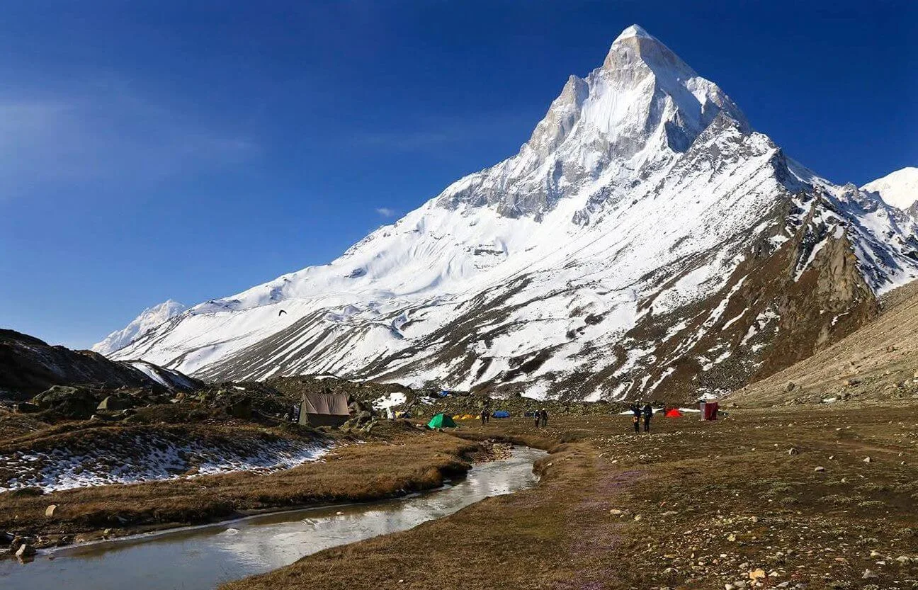
Beyond Gaumukh, the route leaves the main pilgrim trail and ascends steep glacial moraines to Tapovan, a vast alpine meadow situated beneath the iconic Shivling Peak. Surrounded by Meru, Bhagirathi I, II & III, and the upper Gangotri Glacier, Tapovan has long served as a base camp for Himalayan mountaineering expeditions and a seasonal retreat for sadhus.
With glacier travel, boulder fields, sustained altitude, and rapidly changing mountain weather, the trek demands good fitness and previous high-altitude trekking experience.
Quick Facts
Duration
Max Altitude
Difficulty
Best Time
Trek Distance
Trail Atmosphere
Stargazing
Class 1 Dark Sky
Scent Profile
Silence Level
~30 dB
Vertigo Factor
2 / 10
Iconic Spots
Mount Shivling View
Gaumukh Snout
Environment
Nature & Culture
Flora & Fauna
Flora
Fauna
Gaumukh (Cow's Mouth) is the literal source of the Ganga. Tapovan means 'Forest of Penance', where King Bhagirath is said to have meditated for thousands of years to bring the river to Earth.
— Local folklore
Spiritual & Cultural Significance
One of the holiest sites in Hinduism; source of Ganga.
🕐 Shrine Timings: Temple: 06:00 AM - 08:00 PM
Temple Protocols
- •No non-veg/alcohol beyond Gangotri
- •Maintain silence at Tapovan ashrams
Festivals & Dates
Technical Details
Challenge & Preparation
Primarily a cardio demand challenge
A capable trekker's route that balances cardio demand and altitude exposure.
Personal Readiness
Am I ready?
Planning
Logistics & Trail Intel
Getting There
Route to Base
10-hour drive from Dehradun to Gangotri
Shared jeeps available from Dehradun Rly Station and Uttarkashi
Base Village
Gangotri
10,200 ft
Nearest Railhead
Rishikesh
Nearest Airport
Jollygrant Airport
Last ATM
Uttarkashi (95km before Gangotri). No ATMs at Gangotri or on trail.
Nearest Medical Facility
Harsil PHC / Uttarkashi District Hospital
Mobile Signal
Strong 4G at Gangotri (Base). Spotty BSNL at Bhojbasa. Zero signal at the Gaumukh glacier and Tapovan meadow.
Water Sources
Bhagirathi river melt (highly silty; filter required). Clear side-streams at Chirbasa and Bhojbasa campsites. Icy springs at Tapovan.
Charging
Available at Gangotri town. Limited solar charging available at the Lal Baba/Mouni Baba ashrams in Bhojbasa and Tapovan (paid/courtesy).
For Drivers
Road Condition
Good road from Uttarkashi; prone to seasonal landslide blocks near Sukhi Top.
Uttarkashi
Trail Culinary & Diet
Don't miss the Garhwali Mandua Roti
Buy specialized diet items at Uttarkashi town
The Content & Remote Hub
No DronesStrictly prohibited inside the Gangotri National Park boundaries.Top Vlog Spots
Video Calls
patchy-base
Est. 20 Mbps
UPI Reliability
4/10
Base WiFi Available
Permits and Regulations
The trek is inside the Gangotri National Park. Permits are limited to 150 per day by the Forest Department. They must be obtained online or at the Gangotri forest range office. Indian nationals require a photo ID and a medical certificate (mandatory). Foreigners pay a higher daily fee and require registration with the Gangotri police. Note that the park closes in mid-November with the temple and reopens in April/May.
Learn more about how we vet operators and ensure transparency on our why MountRoutes page.
Packing List
Winter Clothing
- Heavy down jacket rated to -15°C
- 3 thermal base layers (full sleeve)
- 2 fleece mid layers
- Hardshell waterproof outer layer
- Heavyweight trekking pants
- Woolen socks (4 pairs)
- Insulated waterproof gloves + liner gloves
- Balaclava and thermal cap
Footwear Snow Gear
- Insulated waterproof trekking boots (Vibram sole preferred)
- Micro-spikes (useful for glacial crossings)
- High-altitude gaiters
- Camp boots
Gear Safety
- Trekking poles (Mandatory)
- Headlamp with spare batteries
- Sleeping bag rated -15°C minimum
- Sunglasses UV400 (Snow goggles preferred)
- Sunscreen SPF 50+
- Personal medical kit (Diamox, ORS, etc.)
Deep Dives
Explore Further
Editor's Notes
Mt. Shivling is often called the 'Matterhorn of India' and is arguably the most beautiful single peak in the country.
This is a pilgrimage for many — seeing the actual source of the Ganga (Gaumukh) from where it originates.
Explore In Detail
Day by Day Itinerary
8-day route reaching 14,600ft. Covers 48km of varied terrain.
→ See full itinerary with altitude profileDifficulty & Fitness
Rated moderate. A moderate trail till Bhojbasa. From Gaumukh, it turns technical. You must walk on the actual Gangotri glacier moraine — a mess of boulders, loose rocks, and hidden crevasses. The final 2km to Tapovan is a steep 70-degree climb on loose scree.
→ See difficulty breakdown and fitness guideCost & Pricing
Packages range from ₹12,000 – ₹30,000. Inclusions and hidden costs vary by operator tier.
→ See full cost breakdownFrequently Asked Questions
How do we get the permit for Gaumukh?
Permits are regulated by the forest department. Usually 150-200 permits are issued per day. These must be applied for in Uttarkashi or via a registered agency.
Can we see Shivling peak?
Yes, Tapovan offers arguably the most iconic views of Mount Shivling (6,543m) from base to summit.
Is it possible to stay at Gaumukh?
No, camping at the snout is prohibited. Trekkers stay at the Bhojwasa camp, which is 4km before the snout.
Who is the "Mouni Baba"?
Tapovan is famous for various sadhus (ascetics) who live there year-round. Mouni Baba was a legendary figure there; currently, others live in small stone huts.
Is the crossing from Gaumukh to Tapovan difficult?
Yes, it involves crossing the Akash Ganga stream and climbing a very steep moraine slope on the far side of the glacier.
Is there mobile signal in Gangotri?
Yes, BSNL works in Gangotri village. Beyond the first 2km of the trail, the signal is gone.
Can we take kids on this trek?
Yes, kids above 10 years with good stamina can do this trek, though Tapovan might be challenging for younger children.
What is the altitude of Tapovan?
Approximately 14,200 ft. It is a stunning high-altitude meadow at the base of Mt. Shivling.
Still deciding?
Compare routes side-by-side to find the perfect match for your fitness, dates, and budget.
Everything you need to know, in one place. Someone else in your group needs to see this.
Planning Gaumukh Tapovan Trek?
Get route conditions, operator updates, and season windows before booking.
Don't miss out! Follow us for route updates@mountroutes|LinkedIn
No spam. Only useful trek updates.
Ready to walk this route?
You’ve read the guide, now find the perfect local team to take you there. Compare our verified list of operators.
Compare verified operators