Explore
Intelligence
Difficulty & Readiness Guide
Is Gaumukh Tapovan Trek Difficult? — Fitness & Altitude Guide
Moderately difficult; demands strong cardiovascular fitness to navigate boulder moraines and a steep 14,000ft altitude gain.
The Question
Can I do this trek?
Preparation Required
Intermediate
Prior Experience
Recommended: 1-2 easy Himalayan treks or regular hiking experience.
Expert Verdict
Highly technical trek requiring physical and mental preparation.
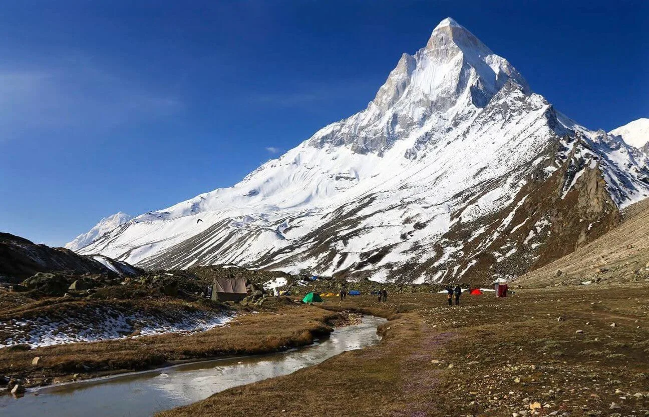
Gaumukh Tapovan Trek
Himalayan Placement · Index 49Route Knowledge
Why is it difficult?
Exertion Index
Primary Challenge
Route Identity
Long-duration high-altitude approach through glacial valleys and moraine terrain.
Primary Drivers
- Maximum sleeping altitude of 14,600 ft
- Grueling summit push with 2,150 ft of elevation gain
- 2 consecutive high-output trekking days
- Peak daily distance of 14 km
View Full Route Analysis
Physiological Demand
Expect long, exhausting days of sustained climbing at high intensity. Your cardiovascular system will be pushed to its absolute limit.
Significant time spent above 12,000ft. Expect shortness of breath and slower pacing.
Comfortable pacing with good recovery options.
Well-defined, stable trails with no technical maneuvers required.
Rolling or gradual terrain with minimal harsh impact on joints.
Terrain Breakdown
A moderate trail till Bhojbasa. From Gaumukh, it turns technical. You must walk on the actual Gangotri glacier moraine — a mess of boulders, loose rocks, and hidden crevasses. The final 2km to Tapovan is a steep 70-degree climb on loose scree.
Summit Day Notes
Day 5 is massive. 10km of high-altitude walking (12,500 to 14,600). The glacier crossing consumes high energy.
The Descent
Descending the Tapovan wall onto the glacier is hard. Use trekking poles and move slowly.
Altitude Profile
Steep jump from 10,200 to 14,600 in 3 trekking days. Mandatory acclimatization at Gangotri is the only fix.
Run AMS Risk Audit →Trail Performance Data
Max Gradient
35%
Hydration
0.5L per km recommended
Loose Surface Sections
- •Gaumukh snout boulder field
- •Final vertical scramble to Tapovan
Personal Readiness
Am I ready?
What this route demands
People who feel comfortable on this route can usually:
Who Can Do This Trek?
Min Age
10+
Max Age
65
Western Toilets at Base
Yes
Solo Female Travelers
Extremely high; safe pilgrimage route with active police presence at checkpoints.
Hazard Profile
What goes wrong?
Common Mistakes on Gaumukh Tapovan Trek
Most injuries and failures on this trail can be avoided by making smarter decisions early on.
Not staying a day in Gangotri — skipping the Day 2 rest almost guarantees AMS at Tapovan.
Thinking it's a 'Pilgrim Walk' — while spiritual, Tapovan is a high-altitude wilderness trek.
Going without a guide — the glacier trail changes every month. Solo trekkers frequently get lost on the moraine.
Poor hydration — high-altitude drying effect is strong in this valley.
Assuming BSNL works throughout — zero network beyond the Gangotri gate.
Safety & Medical Risks
Key Risks
AMS (Acute Mountain Sickness) at 14,000ft
Hidden crevasses on the Gangotri glacier
Rockfall zones ('Kachi Dhang') on the way to Bhojbasa
Extreme temperature drops at Tapovan (-15C)
AMS (Altitude Sickness)
Mandatory 48-hour acclimatization. Drink 5L water. Maintain slow rhythm on the Tapovan wall.
Evacuation Route
Stretcher rescue back to Bhojbasa, then to Gangotri. Helicopter rescue possible from Bhojbasa helipad.
Solo Trekking
NOT RECOMMENDED. The glacier moraine is dangerously shifting. Solo trekking is prohibited beyond Bhojbasa by local authorities without a guide.
Common Trail Ailments
🏥 Nearest ICU: AIIMS Rishikesh / Max Super Specialty Hospital, Dehradun
Tactical Emergency Hub
> 1 day rapid descent to Gangotri roadhead; then 4 hrs drive to Uttarkashi District Hospital. Helipad at Gangotri/Harsil is active for emergency evac.
Auditability
How is this calculated?
Understand This Route Further
Before attempting this route:
Still deciding?
Compare routes side-by-side to find the perfect match for your fitness, dates, and budget.
Still think it's doable? Share this with your trek mate and see if they agree.
Step 2: Seasonal Safety
You know how demanding this route is.
Now find the safest and most reliable season to attempt it.
Check Best Time to Go