Compare operators for Bijli Mahadev to Naggar Forest Walk
Himachal Pradesh
Accessible
MAX 8,070 FT
Compare operators for Bijli Mahadev to Naggar Forest Walk
Himachal PradeshAccessible
Interested in this trek?
We are currently vetting local partners for Bijli Mahadev to Naggar Forest Walk to ensure the highest safety standards. Be the first to know when it's open for booking.
Are you a local operator?
Join our platform to list your verified packages for Bijli Mahadev to Naggar Forest Walk and reach thousands of trekkers directly.
The Bijli Mahadev to Naggar Forest Walk is a 3-day cultural heritage traverse along the right bank of the Beas valley in Kullu district — walking north through the mixed subtropical-temperate forest ridge from the Bijli Mahadev temple (2,460m / 8,070 ft) above Kullu town to Naggar (1,760m / 5,774 ft), the original medieval capital of the Kullu kingdom. The route covers approximately 28 km through forest corridors that connect the two most significant cultural monuments in the Kullu valley floor: the Bijli Mahadev temple (a 200-year-old Shiva temple famous for lightning strikes on its trident — 'bijli' means lightning — which the legend says is absorbed by the Shivling inside to protect the valley) and the Naggar Castle (a 16th-century stone-and-timber fortified palace now a Heritage Hotel, and the home of the Nicholas Roerich Art Gallery). The connecting forest between these two landmarks is the Kullu valley's most intact right-bank mixed forest — deodar cedar, oak, rhododendron, and H...
Trek Highlights
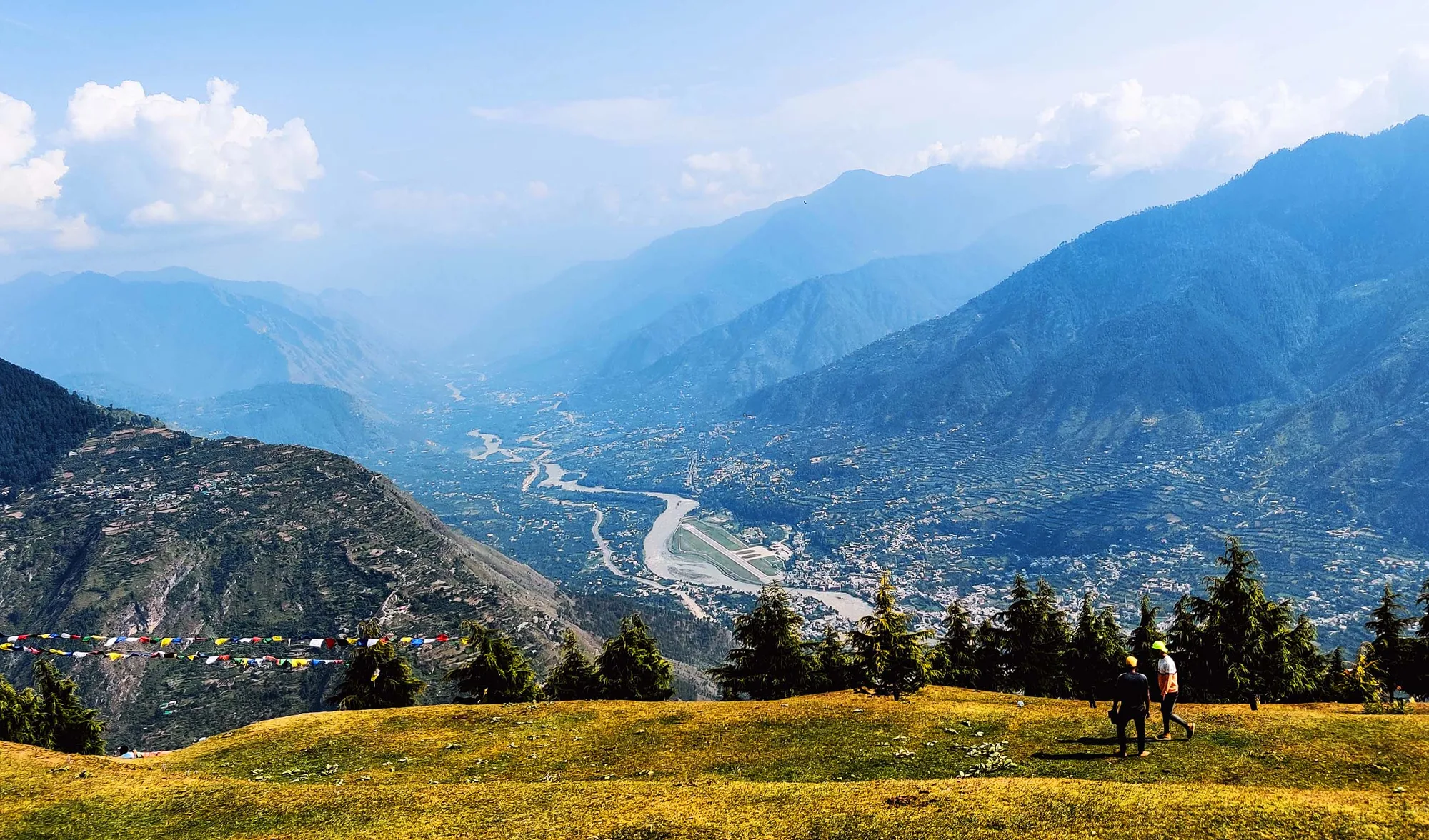
Bijli Mahadev Summit — Beas Valley 180° Panorama
From the Bijli Mahadev temple summit at 8,070 ft: the entire Kullu valley is laid out below in a 180-degree sweep — the Beas river visible as a silver thread through the valley floor, Kullu town visible below, and the full scale of the valley's mountain walls on both sides (Pirpanjal range on the west, the watershed ridges toward Rohtang on the north). In October, the Kullu Dhalpur maidan is visible below during Dussehra — with the palanquin procession visible if the light angle is right.
Nicholas Roerich Gallery — Himalayan Paintings in Original Landscape Context
The Roerich gallery at Naggar contains 40+ of Roerich's Kullu valley and Himalayan paintings — including specific works depicting the ridge, forest, and valley geometry that the walk has just traversed over 3 days. The specific gallery experience after the walk is not a museum visit — it is a comparative geography exercise. You have just walked through the landscape he painted. The paintings become windows.
Bijli Mahadev is a Shiva temple perched on a rocky summit at 8,070 ft above Kullu town, accessible by a 3 km stone-paved path or by the road from Chansari village. The temple is famous throughout Himachal Pradesh for a specific phenomenon: the temple's trident (trishul) is regularly struck by lightning (bijli) during monsoon storms. The legend holds that the Shivling inside the temple absorbs the lightning strike each time, shattering into pieces — after which the priest rebuilds the Shivling from butter and flour before the next strike. The temple has one of the finest panoramic views of the Kullu valley — a 180-degree view of the Beas river sweeping through the valley below, with the Rohtang-Paralkar peaks at the north end. It is a major pilgrimage destination for the Kullu valley communities.
How is the forest walk route structured between Bijli Mahadev and Naggar?
The route descends from Bijli Mahadev (8,070 ft) to the Beas valley floor (4,000-4,500 ft), then crosses to the right bank and follows the forest ridge northward through several mid-altitude forest belts before reaching Naggar (5,774 ft). The walk is not a high-altitude ridge but a forest corridor traverse — relatively gentle on altitude but covering significant ground (28 km over 2 walking days). The local path network through the right-bank forest is known to Kullu valley guides and some shepherd families — it is not marked and not found on hiking maps.
Is there any difficulty in combining this with the standard Bijli Mahadev visit by road?
Most visitors to Bijli Mahadev drive to the Chansari road-end and walk the 3 km stone-paved pilgrim path to the temple — a 1.5 hour round trip. The Forest Walk uses this same path for the Day 1 temple visit, then departs from the standard route by proceeding on the forest track northward rather than returning to the road. The departure point from the pilgrim path is the guide-known junction — invisible without local knowledge.
What is the Roerich connection at Naggar?
Nicholas Roerich (1874-1947) was a Russian artist, explorer, and mystic who made Naggar his home from 1928. His estate — now the Nicholas Roerich Museum — preserves his studio, personal art collection, and the specific viewpoints from Naggar's ridge that he painted repeatedly over 20 years. The walk from Bijli Mahadev arriving at Naggar is an art-geographical journey from the valley's spiritual high point to its artistic high point — these were the two poles of Kullu valley culture that Roerich himself experienced as the primary expressions of the Himalayan spirit.
Can this be done in reverse (Naggar to Bijli Mahadev)?
Yes — the route works equally well in both directions. Starting from Naggar gives the art context (Roerich gallery on Day 1, then forest walk, then Bijli Mahadev pilgrimage on Day 3). Starting from Bijli Mahadev gives the spiritual high point first, then the forest traverse, then the cultural reflection at Naggar. Most guides recommend the south-to-north direction (Bijli Mahadev → Naggar) because the temple's morning light (east-facing, best at 8-9 AM) is worth being at the start.
How long is the forest walk from Bijli Mahadev to Naggar?
The trail connecting Bijli Mahadev to Naggar village is approximately 12 to 14 kilometers long. It mostly involves a long, scenic descent through dense forests and small hamlets.
Is the trail from Bijli Mahadev to Naggar clearly marked?
The trail passes through dense pine and deodar forests and is not always clearly marked. It is highly advisable to take a local guide or use a reliable offline GPS map to avoid getting lost.
What is the best time for the Bijli Mahadev to Naggar forest walk?
The best time is from mid-September to November and March to June. The weather is cool, and the forest canopy provides excellent shade. Avoid the monsoon season due to slippery mud and leeches.
Is the forest walk safe for solo trekkers?
While the forest is beautiful, solo trekking without a guide is not recommended for beginners due to the confusing nature of the forest trails and the occasional presence of wild animals like Himalayan brown bears.
Can this walk be completed in a single day?
Yes, the trek from Bijli Mahadev to Naggar can easily be completed in 5 to 6 hours. Most trekkers start early from Bijli Mahadev and reach the historic Naggar Castle by late afternoon.
What is Bijli Mahadev and why is it significant?
Bijli Mahadev is a Shiva temple perched on a rocky summit at 8,070 ft above Kullu town, accessible by a 3 km stone-paved path or by the road from Chansari village. The temple is famous throughout Himachal Pradesh for a specific phenomenon: the temple's trident (trishul) is regularly struck by lightning (bijli) during monsoon storms. The legend holds that the Shivling inside the temple absorbs the lightning strike each time, shattering into pieces — after which the priest rebuilds the Shivling from butter and flour before the next strike. The temple has one of the finest panoramic views of the Kullu valley — a 180-degree view of the Beas river sweeping through the valley below, with the Rohtang-Paralkar peaks at the north end. It is a major pilgrimage destination for the Kullu valley communities.
How is the forest walk route structured between Bijli Mahadev and Naggar?
The route descends from Bijli Mahadev (8,070 ft) to the Beas valley floor (4,000-4,500 ft), then crosses to the right bank and follows the forest ridge northward through several mid-altitude forest belts before reaching Naggar (5,774 ft). The walk is not a high-altitude ridge but a forest corridor traverse — relatively gentle on altitude but covering significant ground (28 km over 2 walking days). The local path network through the right-bank forest is known to Kullu valley guides and some shepherd families — it is not marked and not found on hiking maps.
Is there any difficulty in combining this with the standard Bijli Mahadev visit by road?
Most visitors to Bijli Mahadev drive to the Chansari road-end and walk the 3 km stone-paved pilgrim path to the temple — a 1.5 hour round trip. The Forest Walk uses this same path for the Day 1 temple visit, then departs from the standard route by proceeding on the forest track northward rather than returning to the road. The departure point from the pilgrim path is the guide-known junction — invisible without local knowledge.
What is the Roerich connection at Naggar?
Nicholas Roerich (1874-1947) was a Russian artist, explorer, and mystic who made Naggar his home from 1928. His estate — now the Nicholas Roerich Museum — preserves his studio, personal art collection, and the specific viewpoints from Naggar's ridge that he painted repeatedly over 20 years. The walk from Bijli Mahadev arriving at Naggar is an art-geographical journey from the valley's spiritual high point to its artistic high point — these were the two poles of Kullu valley culture that Roerich himself experienced as the primary expressions of the Himalayan spirit.
Can this be done in reverse (Naggar to Bijli Mahadev)?
Yes — the route works equally well in both directions. Starting from Naggar gives the art context (Roerich gallery on Day 1, then forest walk, then Bijli Mahadev pilgrimage on Day 3). Starting from Bijli Mahadev gives the spiritual high point first, then the forest traverse, then the cultural reflection at Naggar. Most guides recommend the south-to-north direction (Bijli Mahadev → Naggar) because the temple's morning light (east-facing, best at 8-9 AM) is worth being at the start.
How long is the forest walk from Bijli Mahadev to Naggar?
The trail connecting Bijli Mahadev to Naggar village is approximately 12 to 14 kilometers long. It mostly involves a long, scenic descent through dense forests and small hamlets.
Is the trail from Bijli Mahadev to Naggar clearly marked?
The trail passes through dense pine and deodar forests and is not always clearly marked. It is highly advisable to take a local guide or use a reliable offline GPS map to avoid getting lost.
What is the best time for the Bijli Mahadev to Naggar forest walk?
The best time is from mid-September to November and March to June. The weather is cool, and the forest canopy provides excellent shade. Avoid the monsoon season due to slippery mud and leeches.
Is the forest walk safe for solo trekkers?
While the forest is beautiful, solo trekking without a guide is not recommended for beginners due to the confusing nature of the forest trails and the occasional presence of wild animals like Himalayan brown bears.
Can this walk be completed in a single day?
Yes, the trek from Bijli Mahadev to Naggar can easily be completed in 5 to 6 hours. Most trekkers start early from Bijli Mahadev and reach the historic Naggar Castle by late afternoon.
Are you a local operator?
Join our platform to list your verified packages for this trek.