Difficulty & Readiness Guide
Is Deo Tibba Peak Expedition Difficult? — Fitness & Altitude Guide
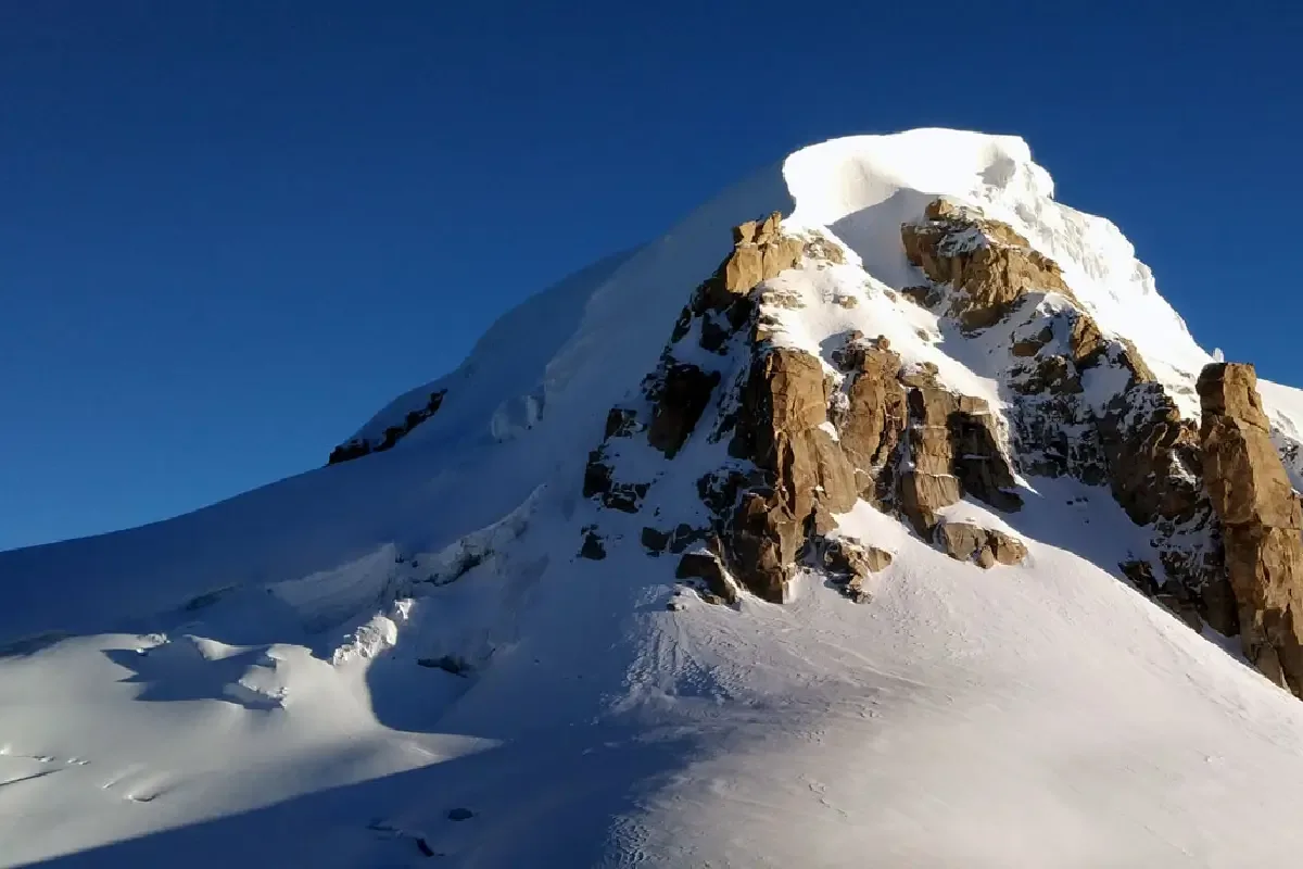
Technically the most demanding Himachal 6,000m peak. Glacier travel, fixed ropes, and steep ice dome require prior mountaineering skills.
Preparation Required
Elite
Prior Experience
Mandatory: Prior high-altitude trekking (16,000ft+) and basic technical knowledge.
Score Engine v3
Why This Score?
Stamina
71/100
Based on average nightly altitude gain, highest campsite, and daily distance. Reflects how hard the average day feels.
Spike Day
47/100
Based on max altitude reached, summit day elevation gain, and summit day distance. Reflects the hardest single day.
Why Deo Tibba Peak Expedition Feels Difficult
An elite-level undertaking with extreme cardio demand, joint & muscle impact, and cumulative fatigue. This route will push every dimension of your physical and mental endurance to the limit.
Physiological Demand
Expect long, exhausting days of sustained climbing at high intensity. Your cardiovascular system will be pushed to its absolute limit.
Steep, punishing ascents and descents that will heavily tax your knees, ankles, and overall joint stability.
Deep wilderness isolation and cumulative fatigue. The mental challenge of enduring days on end in harsh conditions is extreme.
Extreme high altitude exposure. Severe oxygen depletion requires careful acclimatization and peak cardiovascular health.
Rough, uneven trails with occasional scrambling or minor exposure.
Crux Section
Day 10 — Oxygen Peak
Highest exposure point at 19,687ft.
Expedition Grading Context
At 83/100, this expedition is a world-class physical challenge. Beyond the extreme endurance required, you are entering high-altitude technical terrain where standard trekking rules no longer apply.
Deo Tibba Peak Expedition/ 83
Physical Challenge
Caution
Do not confuse 6,001m with 'easy 6,000m'. Deo Tibba's AD grade hanging glacier section is technically harder than any terrain you encounter on Kang Yatse II or UT Kangri.
Terrain Breakdown
A complex technical peak with significant crevasse navigation on the Jagatsukh Glacier followed by steep ice on the summit dome.
Summit Day Notes
One of the most technical peaks under 6,100m in Himachal. Summit dome requires confident front-pointing and fixed-rope management.
The Descent
Rappel the summit dome mandatory. Glacier descent requires careful rope team management.
Preparation
Prior experience on glaciated terrain and basic ice climbing techniques mandatory.
Altitude Profile
Technical approach across a badly crevassed glacier before the steep summit push.
Run AMS Risk Audit →Route Stress Forecast
Highest exposure point at 19,687ft.
Deep 6,337ft descent will test joint stability.
First major altitude jump occurs on Day 3.
*Forecast derived from route geometry and altitude profile. External variables (weather/group) remain the final authority.
Trail Performance Data
Max Gradient
55%
Hydration
1.5L per km recommended
Loose Surface Sections
- •Base camp to Summit is entirely loose scree and hard ice
Common Mistakes on Deo Tibba Peak Expedition
Most injuries and failures on this trail can be avoided by making smarter decisions early on.
Underestimating glacier navigation complexity
Summit fever on the dome
Safety & Medical Risks
Key Risks
Serac fall from hanging glacier
Crevasse on glacier approach
HACE above 5,000m
Rockfall on moraine descent
AMS (Altitude Sickness)
Systematic acclimatization via Chotta Chandratal hike is critical. Do not rush to ABC without a full rotation day.
Evacuation Route
Descend to Tainta Base Camp, then trek to Jagatsukh for vehicle evacuation to Manali hospital.
Solo Trekking
Solo climbing is strongly discouraged and generally not permitted. This is a technical 6,001m peak requiring experienced guides, ropes, and ABVIMAS coordination.
Common Trail Ailments
🏥 Nearest ICU: Dr. RPGMC, Tanda / Fortis Hospital, Kangra
Tactical Emergency Hub
> Immediate vehicle evacuation back down to Keylong if AMS strikes at Base Camp.
Who Can Do This Trip?
Min Age
18+
Max Age
55
Western Toilets at Base
No
Solo Female Travelers
Must join an established, registered IMF expedition group.
Expert Verdict
Highly technical peak requiring physical and mental preparation.
Ready to book? Compare verified operators for Deo Tibba Peak Expedition — transparent pricing, no paid rankings.
Want to know which operators carry certified guides and medical support? See operator safety ratings for Deo Tibba Peak Expedition
Also on this trek
Still deciding?
Compare routes side-by-side to find the perfect match for your fitness, dates, and budget.
Still think it's doable? Share this with your trek mate and see if they agree.
Fit for the challenge?
For challenging treks, safety is paramount. Find operators prioritizing medical support and guide expertise.
Compare operator safety scores