
Explore
Intelligence
Essential Planning Guide
Gupt Khal Expedition — Complete Guide (2026)
Vibe & Scenery
The Experience
Introduction
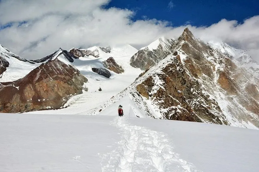
Gupt Khal, or the "Secret Pass", is among the highest and least-travelled mountaineering traverses in the Garhwal Himalayas. Explored during Frank Smythe's Himalayan journeys in the early twentieth century, the route connects the upper Dhauli Ganga valley near the Indo-Tibetan frontier with the Alaknanda basin through an extensive glaciated landscape.
The expedition crosses large glacier systems, steep snow slopes, serac zones, and heavily crevassed terrain where route selection changes from season to season. Unlike trekking expeditions, progress depends on technical climbing skills, rope systems, and careful risk management rather than established trails.
Because of its altitude, isolation, and sustained technical commitment, Gupt Khal is reserved for experienced alpine teams with strong glacier and rescue experience.
Quick Facts
Duration
Max Altitude
Difficulty
Best Time
Trek Distance
Trail Atmosphere
Stargazing
Class 1 Dark Sky
Scent Profile
Silence Level
~10 dB
Vertigo Factor
9 / 10
Iconic Spots
Kamet & Nilkantha Panorama
Bankkund & Meru Ice Fields
Medial Moraine Ridges
Gupt Khal Col
High-Altitude Glacial Desert
Environment
Nature & Culture
Flora & Fauna
Flora
Fauna
Frank Smythe named it the 'Secret Pass' because it is completely hidden from the Bhyundar valley until you are directly upon it.
— Local folklore
Spiritual & Cultural Significance
The Alaknanda valley side (Ghangaria/Govindghat) is heavily tied to the Sikh pilgrimage site of Hemkund Sahib and the Hindu shrine of Badrinath.
Temple Protocols
Technical Details
Challenge & Preparation
Primarily a terrain ruggedness and cardio demand challenge
A demanding expedition with extreme terrain ruggedness and cardio demand.
Personal Readiness
Am I ready?
Planning
Logistics & Trail Intel
Getting There
Route to Base
Fly to Dehradun (Jolly Grant) or take a train to Rishikesh
From Rishikesh, it's a 10-12 hour drive to Joshimath, followed by a 4-hour drive to Ghamsali
Base Village
Ghamsali
10,850 ft
Nearest Railhead
Rishikesh
Nearest Airport
Jolly Grant, Dehradun
Last ATM
Joshimath
Nearest Medical Facility
Army Hospital / Primary Health Center in Joshimath
Mobile Signal
None
Water Sources
Melted snow/ice only.
Charging
None. Solar panels required.
For Drivers
Road Condition
The highway to Joshimath is prone to landslides during the monsoon. The road from Joshimath to Ghamsali is a highly sensitive military border road.
Joshimath
Trail Culinary & Diet
Don't miss the Freeze-dried expedition meals; high-calorie soups and Tsampa.
Buy specialized diet items at Dehradun / Rishikesh
The Content & Remote Hub
UPI Reliability
1/10
Permits and Regulations
Because the route borders the Tibetan region (Ghamsali) and enters the Nanda Devi Biosphere Reserve/Valley of Flowers National Park, military and forest checkpoints are extremely strict. The IMF permit is non-negotiable.
Learn more about how we vet operators and ensure transparency on our why MountRoutes page.
Packing List
Technical Hardware
- 12-point Mountaineering Crampons
- Classic straight-shaft Ice Axe
- UIAA Certified Climbing Harness
- Ascender (Jumar) and Descender
- Locking Carabiners and Prusik loops
- Climbing Helmet
High-Altitude Clothing
- Expedition-grade down suit or heavy down jacket (-25°C rating)
- Gore-Tex Hardshell jacket and pants
- 3 sets of heavy merino wool baselayers
- Fleece mid-layers
- Waterproof alpine mountaineering gloves with thermal liners
- Balaclava and UV-protective Buff
- 4 pairs of expedition-grade woolen socks
Footwear
- Double Mountaineering Boots (e.g., La Sportiva G2 or Spantik)
- Heavy-duty waterproof gaiters
- Camp booties (down-filled) for tent use
- Anti-shock trekking poles with snow baskets
Survival & Medical
- Category 4 Glacier Glasses (absolutely critical)
- High-lumen headlamp with spare lithium batteries
- Personal medical kit (Diamox, Dexamethasone, painkillers)
- High SPF Sunscreen (50+) and zinc oxide lip balm
- Insulated Nalgene water bottles (to prevent freezing)
Deep Dives
Explore Further
Editor's Notes
Explore In Detail
Day by Day Itinerary
14-day route reaching 19,052ft. Covers 61.0km of varied terrain.
→ See full itinerary with altitude profileDifficulty & Fitness
Rated challenging. You spend over 6 days entirely on ice and moraine, navigating a maze of crevasses. The psychological toll of continuous glacial travel is immense.
→ See difficulty breakdown and fitness guideCost & Pricing
Packages range from ₹85,000 – ₹1,50,000+. Inclusions and hidden costs vary by operator tier.
→ See full cost breakdownFrequently Asked Questions
How does Gupt Khal compare to Kalindi Khal?
They are peers in difficulty. Kalindi Khal is higher (19,500 ft) and longer, but Gupt Khal often features steeper, more technical ice climbing on the approach to the pass and crosses two passes (Twin Passes).
Can I do this if I have only done Everest Base Camp?
Absolutely not. EBC is a teahouse trek on a well-paved trail. Gupt Khal is an unmapped mountaineering expedition requiring crevasse rescue skills, jumaring, and ice climbing.
Why is it called the Twin Passes?
Because immediately after crossing Gupt Khal (19,052 ft) and descending into the glacier, you must ascend and cross Bhyundar Khal (16,700 ft) to exit into the Valley of Flowers.
Do I need double mountaineering boots?
Yes. Single boots will result in frostbite during the 1:00 AM pass crossing where temperatures drop to -20°C.
What happens if a storm hits while on the glacier?
You hunker down in the tents. Navigation in a whiteout over heavily crevassed terrain is suicidal. This is why buffer days and extra rations are mandatory.
Is there a trail on the glacier?
No. The glacier shifts every year. The lead guide must constantly probe for hidden crevasses and find a safe line through the icefall maze.
How steep is the pass?
The final headwall to Gupt Khal can be 60-70 degrees of hard ice or snow, requiring fixed static ropes and mechanical ascenders (Jumars) to climb safely.
What is the psychological crux of the expedition?
The sheer commitment. Once you cross the Bankund icefall, retreating is incredibly difficult. You are locked into a massive valley of ice with only one way out: over a 19,052 ft pass.
Still deciding?
Compare routes side-by-side to find the perfect match for your fitness, dates, and budget.
Everything you need to know, in one place. Someone else in your group needs to see this.
Planning Gupt Khal Expedition?
Get route conditions, operator updates, and season windows before booking.
Don't miss out! Follow us for route updates@mountroutes|LinkedIn
No spam. Only useful trek updates.
Ready to walk this route?
You’ve read the guide, now find the perfect local team to take you there. Compare our verified list of operators.
Compare verified operators